
Hide
Caistor
hide
Hide
hide
- Archives & Libraries
- Bibliography
- Business & Commerce Records
- Cemeteries
- Census
- Church Directories◬
- Church History
- Church Records
- Churches
- Civil Registration
- Correctional Institutions◬
- Court Records◬
- Description & Travel
- Directories
- Emigration & Immigration◬
- Gazetteers
- Genealogy◬
- Historical Geography◬
- History
- Land & Property◬
Hide
hide
Hide
Hide
hide
- Manors
- Maps
- Medical Records
- Migration, Internal◬
- Military History
- Military Records
- Names, Geographical
- Names, Personal
- Naturalisation & Citizenship◬
- Newspapers◬
- Occupations◬
- Politics & Government
- Poor Houses, Poor Law
- Population
- Postal & Shipping Guides◬
- Probate Records◬
- Public Records◬
- Schools
- Societies◬
- Voting Registers◬
Hide
CAISTOR, or Castor, a small town, a parish, a subdistrict, and a district in Lincoln. The town stands on the side of a hill, on the Wolds, 4 miles ENE of Moortown r. station, and 7½ SE of Glanford Brigg. It was called by the ancient Britons Caer-Egarry; and by the Saxons Thong-Ceastre. A Roman station was on its site; and a castle was built at it by the Saxon Hengist. Rowena, the daughter of Hengist, was married here to Vortigern; and Egbert, in 827, here subdued Wiglof, king of Mercia.
From: John Marius WILSON's "Imperial Gazetteer of England and Wales (1870-72)"
Hide
The Caistor Library is normally open 7 days per week (yes, even Sundays!) and is located in a former Methodist Chapel at:
- Caistor Arts & Heritage Centre
- 28 Plough Hill
- Caistor
The Library offers computer access and has a monthly Family History Workshop. There is a cafe downstairs. This is a Community Library, primarily staffed by volunteers, and with limited County Council library support.
The Caistor Arts and Heritage Centre is a local museum worthy of exploration. You might find relatives in their photograph collection.
Rev. David Saunders. "Portraits of Caistor, Lincolnshire: People, Pubs and Police", paperback, Tucann Design & Print Publ., 2005, ISBN: 978-1873257470.
- From the Stamford Mercury Friday 15th February 1793. [Mark in Barcelona]
- The Public Cemetery was formed in 1849 under a board of trustees and used principally by the non-conformist churches and chapels.
- The Cemetery is west of the town on North Kelsey Road, just after Mallard Drive.
- John FIRTH has a photograph of Caistor cemetery on Geo-graph, taken in July, 2010.
- Paul HARROP has a photograph of the parish chuchyard on Geo-graph, taken in June, 2016.
- David BROWN also has a photograph of the Church graveyard on Geo-graph, taken in August, 2020.
- Neil THEASBY has a photogrsph of the WEATHERHOG gravestone on Geo-graph, taken in December, 2012.
| North Kelsey Road, Caistor, Cemetery |
- The parish was in the Caistor sub-district of the Caistor Registration District.
- Check our Census Resource page for county-wide resources.
- The table below gives census piece numbers, where known:
| Census Year | Piece No. |
|---|---|
| 1841 | H.O. 107 / 630 |
| 1851 | H.O. 107 / 2113 - 2115 |
| 1861 | R.G. 9 / 2392 |
| 1871 | R.G. 10 / 3420 |
| 1891 | R.G. 12 / 2621 - 2622 |
| Chapel Street, Caistor, Independent |
| Church Street, Caistor, Congregationalist |
| North Kelsey Road, Caistor, Cemetery |
| Central Chapel, Chapel Street, Caistor, Methodist (Wesleyan) |
| Church Street, Caistor, Methodist (Wesleyan Reform) |
| Westgate Chapel, Horse Market, Caistor, Methodist (Primitive) |
| St Thomas More, Caistor, Roman Catholic |
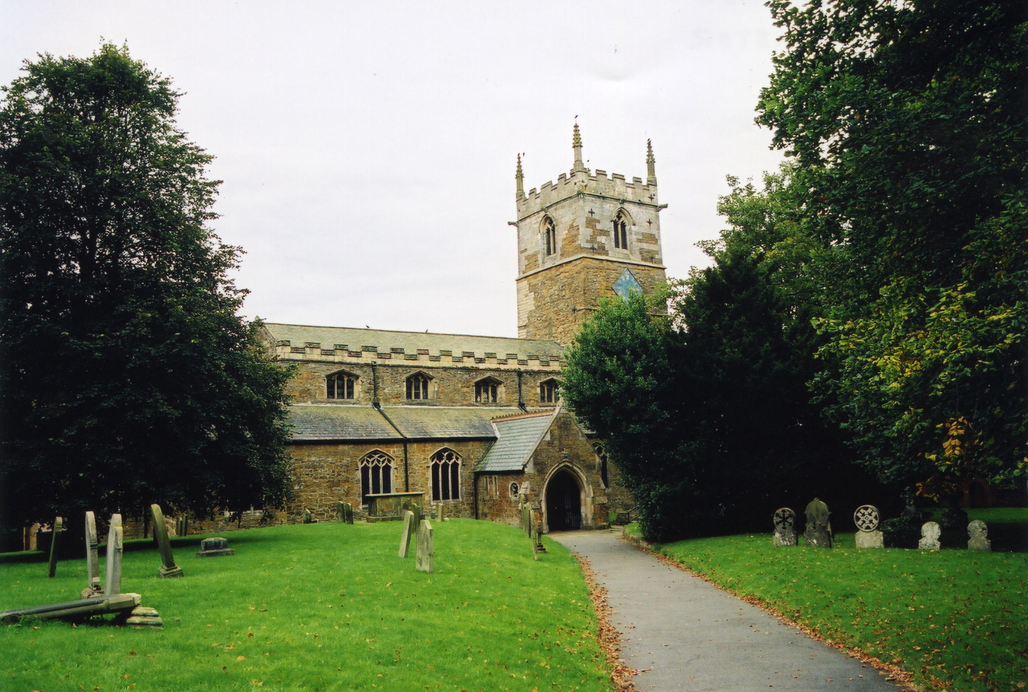
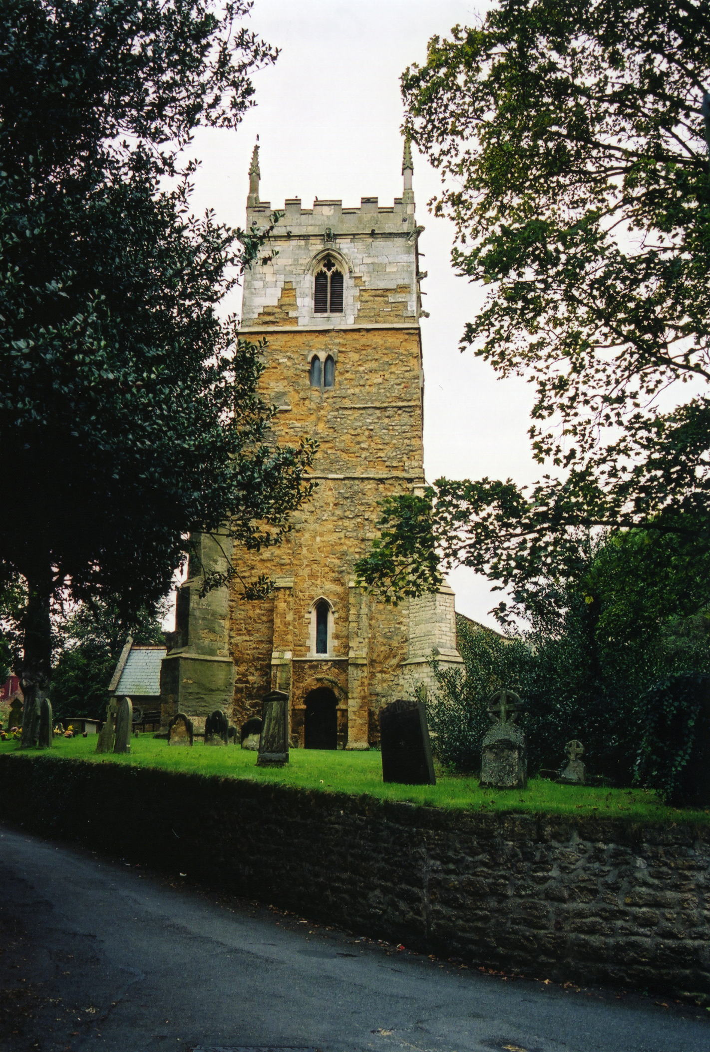
- The Anglican parish church is dedicated to Saint Peter and Saint Paul.
- The church was built in the reign of Henry III.
- The church tower contains Saxon and Norman work.
- The church was restored in 1856 and again in 1863.
- Renee REDSHAW provides this history of the Gad Whip.
- The churchyard was closed for burials in 1909.
- Here are two photographs of the church supplied by Ron COLE (who retains the copyright):
- The Anglican parish register dates from 1584.
- We have the beginnings of the church parish register extract in a text file for your review. Your additions are welcomed.
- The Lincolnshire FHS has published several marriage indexes and a burial index for the Westwold Deanery to make your search easier.
- The Congregationists established a chapel here in 1842. The Wesleyan Methodists built a chapel in 1842. The Primitive Methodists built their chapel in 1878.
- For more information on these chapel records, see Non-Conformist Church Records.
- Check our Church Records page for county-wide resources.
- The parish was in the Caistor sub-district of the Caistor Registration District.
- Check our Civil Registration page for sources and background on Civil Registration which began in July, 1837.
Caistor is a town and a parish in the north of Lincolnshire, in the Wold Hills. It is 23 miles northeast of Lincoln and 11 miles southwest of Grimsby. The parish covers some 6,500 acres and includes the small hamlets of Hundon, Fonaby, and Audleby, as well as Caistor Moor. Canada sits about a half mile east out on the old Grimsby Road.
The town of Caistor sits on a hill and is one of the higher points in Lincolnshire. If you are planning a visit, see:
- By automobile, take the A46 Trunk Road north out of Lincoln or southwest out of Grimsby.
- The town has a town information page.
- J. THOMAS has a photograph of the Town Sign on Geo-graph, taken in April, 2014.
- Colin Park has a photograph of the Market Place on Geo-graph, taken in August, 2021.
- See our touring page for area resources.
- Use the local version supplied by William Wallworth: Pigot 1828 Directory.
- Ask for a calculation of the distance from Caistor to another place.
- This place was a Roman station and traces of masonary from that era can still be found.
- Find out more about Roman Caistor at the Caistor Roman Project website.
- The Saxon Vortigen is said to have married Rowena, daughter of Hengist, here in 453.
- Paul HARROP has a photograph of the long Roman Road out of Caistor west toward North Kelsey on Geo-graph, taken in June, 2016.
- Caistor was a Royal Mint from 970 'til 1042.
- Caistor was involved in the October 1536 Lincolnshire Rising.
- Plague touched the town in 1590, but did not ravage it.
- A great fire swept through the town in 1681, consuming more than half the buildings and leaving 45 families in poverty.
- Market Day was on Saturdays.
- A Police Station was built here in 1855.
- The Caistor Gas Works was erected in 1856.
- The Public Hall in High Street was erected in 1887.
- Michael GARLICK has a photograph of the Caistor Lion Monument of 1897 on Geo-graph, taken in September, 2016. The monument honors Queen Victoria's 60 years on the throne.
- The Fleece Inn is in the hamlet of Canada, just off the A1173 trunk road. It is now a Montessori School.
- Roger CORNFOOT has a photograph of the converted Fleece Inn on Geo-graph, taken in May, 2015.
Wikipedia tells us "Audleby is a hamlet just north of Fonaby. It is recorded in the 1086 Domesday Book with 33 households, which at the time was considered quite large. Today it is listed as a deserted medieval village (DMV). Audleby House on Brigg Road is a Grade II listed building."
- See our Maps page for additional resources.
You can see maps centred on OS grid reference TA117013 (Lat/Lon: 53.496551, -0.317644), Caistor which are provided by:
- OpenStreetMap
- Google Maps
- StreetMap (Current Ordnance Survey maps)
- Bing (was Multimap)
- Old Maps Online
- National Library of Scotland (Old Ordnance Survey maps)
- Vision of Britain (Click "Historical units & statistics" for administrative areas.)
- English Jurisdictions in 1851 (Unfortunately the LDS have removed the facility to enable us to specify a starting location, you will need to search yourself on their map.)
- Magic (Geographic information) (Click + on map if it doesn't show)
- GeoHack (Links to on-line maps and location specific services.)
- All places within the same township/parish shown on an Openstreetmap map.
- Nearby townships/parishes shown on an Openstreetmap map.
- Nearby places shown on an Openstreetmap map.
In 1937 the Poorlaw Union residents were all transferred to the Institution at Holbeach (part of the group of Institutions for the Mentally Defective covering the whole of Lincolnshire). Repairs and new structures were built and central heating installed. In January 1938 the Institution was re-opened. In 1948 the passing of the National Health Act brought the title of ‘Hospital’ into being, and it has been Caistor Hospital ever since. In the summer of 1990, 190 years from its inception, the doors finally closed.
Hospitals were not required to archive their records, however you may find accounting and photographic records in the archives.
Richard CROFT has a photograph of part of Caistor Hospital on Geo-graph, taken in February, 2007.
Richard CROFT has another photograph of Caistor Hospital on Geo-graph, taken in February, 2007. At that time, the buildings were quite derelict.
- Hengist, a Saxon general, reputedly built the Castrum here after defeating the Picts and Scots. It is from that name that the town derives its name.
- Shortly after World War I a War Memorial was erected near the Market Place. A cross on a shaft, standing on an octagonal base with eight panels and three steps, it honours the men who fell in the Great War.
- The RAF opened an airfield here in September, 1940, as a relief airfield for RAF Kirton in Lindsey. Because of the hilly terrain nearby, the field was used primarily for training. The field was grass only.
- The airfield closed in 1945.
- The airfield reopened as a Thor missile base in 1959.
- The missile base closed in 1963.
- Neal THEASBY has a photograph of the War Memorial on Geo-graph, taken in December, 2012.
There is a war memorial at the corner of Market Place and South Street and a Roll of Honour on oak panels in The Church of Saints Peter and Paul. See them and the list of names at the Roll of Honour site.
- The ancient Britons called this place "Caer-Egarry".
- Caistor is derived from the Roman word "Castra", meaning "camp" or garrison place.
- When the Romans left and the Saxons inhabited this town, they called it "Tunnaceaster".
- The name Caistor is pronounced by the locals as either "Kay-yes-ter" or "Ker-yes-ter".
- In old records you may see the name as "Caster" or "Castor".
- Click to see the text file: Bailey's British Merchant's and Trader's Useful Companion for 1784 list of names. [Mark in Barcelona]
- This place was an ancient township and parish in Lincolnshire and became a modern Civil Parish when those were established.
- The parish was in the ancient Yarborough Wapentake in the West Lindsey district in the parts of Lindsey.
- Caistor is governed by a Town Council. You may contact them regarding civic or political issues, but they are NOT staffed to assist you with family history searches.
- Today's district governance is provided by the West Lindsey District Council.
- Bastardy cases would be heard in the Caistor petty session hearings held in the Court House on the fourth Wednesday of each month and nearly every Saturday.
- A House of Industry was built on the west side of town in 1800 to employ the chronic poor under the Gilbert Act.
- The Common Lands were enclosed here in 1814.
- With the Poor Law Amendment Act reform of 1834, this parish became the centre of the Caistor Poor Law Union.
Year Inhabitants 1801 861 1811 1,051 1821 1,253 1831 1,377 1851 2,166 1861 2,141 1871 2,012 1881 1,867 1891 1,788 1901 1,567 1911 1,544
- The Free Grammar School was founded in 1630 by way of the will of Francis RAWLINSON, the church rector. A subsequent endowment was made by William HANSARD.
- Jo TURNER has a photograph of the Old Grammar School on Geo-graph, taken in May, 2015.
- Built in 1938, Caistor Yarborough School was named after John Edward PELHAM, the 7th Earl of Yarborough. It became an academy in 2011 and changed its name to Caistor Yarborough Academy.
- David Howard has a photograph of the Exit from Caistor Yarborough Academy on Geo-graph, taken in June, 2019.
- See our Schools page for more information on researching school records.