
Hide
Carlby
hide
Hide
hide
Hide
hide
Hide
Hide
Hide
The Library at Bourne should prove useful in your research.
The Library at Spalding, although outside the Civil Registration subdistrict, may also be useful in your research.
- Rex NEEDLE has a photograph of St. Stephen's Church on Geo-graph, taken in August, 1999. You can see that they have kept the gravestones free of weeds.
- The parish was in the Bourne sub-district of the Bourne Registration District.
- Check our Census Resource page for county-wide resources.
- The table below gives census piece numbers, where known:
| Census Year | Piece No. |
|---|---|
| 1841 | H.O. 107 / 616 |
| 1851 | H.O. 107 / 2095 |
| 1861 | R.G. 9 / 2318 |
| 1871 | R.G. 10 / 3316 |
| 1891 | R.G. 12 / 2557 |
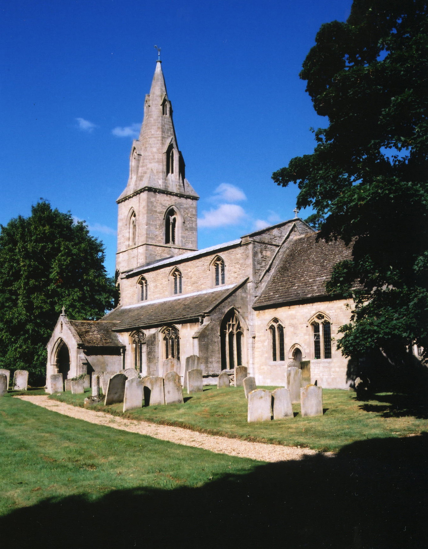
- The Anglican parish church is dedicated to Saint Stephen.
- The church was originally built in the 12th to the 15th century.
- The present church building dates from 1734 and is in the Early English style..
- The church seats about 130.
- There is a photograph of St. Stephen's Church on the Wendy PARKINSON Church Photos web site.
- Here is a photo of the church, taken by Ron COLE (who retains the copyright):
- Anglican parish registers exist from 1660, but I.G.I. entries cover as far back as 1562.
- Parish registers are on file at the Society of Genealogists, covering 1668 - 1837.
- The Lincolnshire FHS has published several marriage indexes and a burial index for the Aveland and Ness Deanery to make your search easier.
- The National Burial Index lists 318 burials between 1813 and 1900 for this parish.
- Check our Church Records page for county-wide resources.
- The parish was in the Bourne sub-district of the Bourne Registration District.
- Check our Civil Registration page for sources and background on Civil Registration which began in July, 1837.
Carlby is both a village and parish which lies just east of the A1 trunk road and north of the A16, south of Careby Parish and just 5 miles north of Stamford. The West Glen River passes down the south side of the parish and Ryhall in Rutland is just across the river. The parish covers about 1,400 acres.
The village of Carlby was described in 1911 as a "small agricultural village, pleasantly standing on a slight elevation on the road from Stamford to Bourne, close to the borders of Rutland". If you are planning a visit:
- By automobile, the village is just west off the A6121 trunk road between Stamford and Bourne, just north of Essendine in Rutland.
- Jonathan BILLINGER has a photograph of the Village Hall on Geo-graph, taken in December, 2010. The webpage author suggests that you stop in and ask for a schedule of forth-coming events.
- John BILLINGER also wants you know that you are Welcome to Lincolnshire with this photograph on Geo-graph, taken in December, 2010. Please leave all your money here.
- Mat FASCIONE provides a photograph of the Village Sign on Geo-graph, taken in March, 2014. Just to guarantee that you are there!
- And Robert HARVEY also has a photograph of the Village Sign (better lit) on Geo-graph, taken in May, 2021. That's the Village Hall in the background.
- See our touring page for visitor services.
- Ask for a calculation of the distance from Carlby to another place.
- Ian DAIR has written "Carlby - Then and Now" (62 pages), which is available for around £5, (which goes to village organisations). Postage and handling are extra. You can contact him at: Ian Dair.
- Richard CROFT has a photograph of the ancient medieval churchyard cross on Geo-graph, taken in July, 2008.
In 1919, Colonel Charels BIRCH-REYNALDSON was a landowner in this parish. He was likely living in nearby Holywell parish at the time.
- The National Grid Reference is TF 0514.
- You'll want an Ordnance Survey Explorer #248 map, which has a scale of 2.5 inches to the mile.
- See our Maps page for additional resources.
You can see maps centred on OS grid reference TF050141 (Lat/Lon: 52.714303, -0.447006), Carlby which are provided by:
- OpenStreetMap
- Google Maps
- StreetMap (Current Ordnance Survey maps)
- Bing (was Multimap)
- Old Maps Online
- National Library of Scotland (Old Ordnance Survey maps)
- Vision of Britain (Click "Historical units & statistics" for administrative areas.)
- English Jurisdictions in 1851 (Unfortunately the LDS have removed the facility to enable us to specify a starting location, you will need to search yourself on their map.)
- Magic (Geographic information) (Click + on map if it doesn't show)
- GeoHack (Links to on-line maps and location specific services.)
- All places within the same township/parish shown on an Openstreetmap map.
- Nearby townships/parishes shown on an Openstreetmap map.
- Nearby places shown on an Openstreetmap map.
For a photograph of the Carlby War Memorial plaque in the church, and the names on it, see the Roll of Honour site.
- The name derives from the Old Scandinavian Karl+by or "village of the freemen" and first appears in the 1086 Domesday Book as Carleby.
[A. D. Mills, "A Dictionary of English Place-Names," Oxford University Press, 1991].
- This place was an ancient parish in Lincolnshire and became a modern Civil Parish when those were established.
- The parish was in the ancient Ness Wapentake in the South Kesteven district in the parts of Kesteven.
- In March, 1887, this Civil Parish was enlarged by gaining Wood's Farm on Barber's Hill from Essendine Civil Parish.
- You can contact the local Parish Council regarding civic or political issues, but they are NOT staffed nor funded to help you with family history searches. The parish also holds an annual Parish Meeting for all citizens to attend.
- For today's district governance, contact the South Kesteven District Council.
- Bastardy cases were heard in the Bourne petty session hearings on Mondays.
- At the enclosure of the Common Land about 7 perches of land were awarded to the poor.
- This parish charities generated about £5 yearly in 1911 for coal to be distributed to the poor.
- As a result of the 1834 Poor law Amendment Act, the parish became part of the Bourne Poor Law Union.
- The children of this parish attended school in Essendine in Rutlandshire.
- See our Schools page for more information on researching school records.