
Hide
Colsterworth with Woolsthorpe
hide
Hide
hide
Hide
hide
Hide
Hide
hide
Hide
Hide
The Library at Grantham will prove useful in your research.
- Mat FASCIONE has a photograph of some of the Slate Gravestones in St. John's Churchyard on Geo-graph, taken in June, 2014.
- A Cemetery was formed in the hamlet of Woolsthorpe in 1880 for Non-conformists. It was under the direction of the parish council.
- The parish was in the Colsterworth sub-district of the Grantham Registration District.
- In 1890, after the Poor Law Union was reorganized, the parish was in the "Grantham South" sub-district of the Grantham Registration District.
- Check our Census Resource page for county-wide resources.
- The table below gives census piece numbers, where known:
| Census Year | Piece No. |
|---|---|
| 1841 | H.O. 107 / 616 |
| 1851 | H.O. 107 / 2102 |
| 1861 | R.G. 9 / 2347 |
| 1871 | R.G. 10 / 3355 |
| 1891 | R.G. 12 / 2582 |
- There was a Christian Church here in the year 1000 AD.
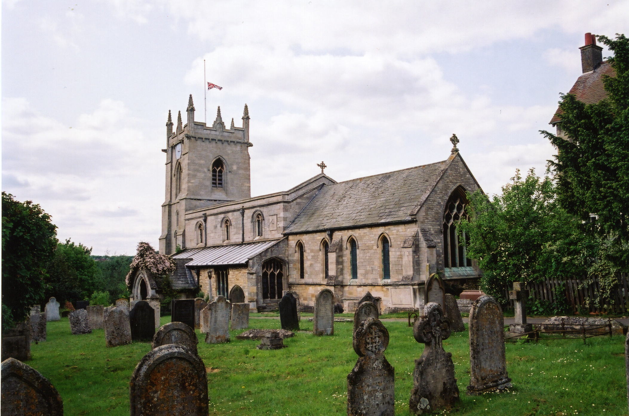
- The Anglican parish church is dedicated to Saint John the Baptist.
- Some arches on the south side of the building are of Saxon origin.
- Woolsthorpe hamlet once contained a Chapel of Ease, but this was no longer in use by 1842.
- St. John's was restored in 1876.
- The church is a Grade I structure in English Heritage.
- St. John's seats 275.
- J. HANNAN-BRIGGS has a photograph of St John the Baptist Church on Geo-graph, taken in July, 2013.
- Here is a photo of St. John the Baptist's Church, taken by Ron COLE (who retains the copyright):
- Anglican parish registers exist from 1561. (Kelly's 1900 Directory tells us 1572.)
- The parish is also listed in Boyd's Marriage Index, covering the period from 1573 - 1837.
- We have a partial register extract. Your additions are welcome.
- The Lincolnshire FHS has published several marriage and burial indexes for the Beltisloe Deanery to make your search easier.
- The parish at one time had a thriving Wesleyan Methodist chapel, first built in 1836.
- Marathon has a photograph of the Methodist Church on Geo-graph, taken in September, 2019.
- For more information on researching this chapel, see our non-conformist church records page.
- Check our Church Records page for county-wide resources.
- The parish was in the Colsterworth sub-district of the Grantham Registration District.
- In 1890, after the Civil Registration District was reorganized, the parish was in the "Grantham South" sub-district of the Grantham Registration District.
- Check our Civil Registration page for sources and background on Civil Registration which began in July, 1837.
Colsterworth is both a village and parish on the River Witham. Cringle Brook forms part of the western parish border. Across the Brook is Leicestershire. Colsterworth is just 2 miles south of the township of Easton. The parish includes the hamlets of Woolsthorpe and Twyford and covers about 2,700 acres.
Woolsthorpe hamlet is an ancient village, lying about a mile west of Colsterworth. It was here that Sir Isaac NEWTON reportedly saw an apple fall, circa 1665, giving rise to his theories on gravitation. If you are planning a visit:
- By automobile, take the A1 motorway between Stamford and Grantham. The village is located where the A151 from Bourne intersects the motorway, about 8 miles south of Grantham.
- Visit our touring page for more sources.
- Ask for a calculation of the distance from Colsterworth with Woolsthorpe to another place.
This is, indeed, the place where the future Sir Isaac NEWTON was christened in 1642 (under the New Calendar, 1643).
- J. HANNAN-BRIGGS has a photograph of Newton's sundial on Geo-graph, taken in July, 2013.
- Mat FASCINOE has a photograph of The White Lion on Geo-graph, taken in August, 2019.
- At the Manor House in Woolsthorpe, you'll find that Isaac Newton was born in the parish in the hamlet of Woolsthorpe on 25th December 1642. We have a short extract from a biography.
- Claire WARD has a photograph of Woolsthorpe Manor on Geo-graph, taken in July 1993.
- The national grid reference is SK 9324.
- You'll want an Ordnance Survey Explorer #247 map, which has 2.5 inches to the mile scale.
- See our Maps page for additional resources.
You can see maps centred on OS grid reference SK930242 (Lat/Lon: 52.807342, -0.621803), Colsterworth with Woolsthorpe which are provided by:
- OpenStreetMap
- Google Maps
- StreetMap (Current Ordnance Survey maps)
- Bing (was Multimap)
- Old Maps Online
- National Library of Scotland (Old Ordnance Survey maps)
- Vision of Britain (Click "Historical units & statistics" for administrative areas.)
- English Jurisdictions in 1851 (Unfortunately the LDS have removed the facility to enable us to specify a starting location, you will need to search yourself on their map.)
- Magic (Geographic information) (Click + on map if it doesn't show)
- GeoHack (Links to on-line maps and location specific services.)
- All places within the same township/parish shown on an Openstreetmap map.
- Nearby townships/parishes shown on an Openstreetmap map.
- Nearby places shown on an Openstreetmap map.
- Ian YARHAM has a photograph of the War Memorial on Geo-graph, taken in August, 2013.
There is a photograph of the war memorial and a list of the names on it at the Roll of Honour site.
There is a second set of memorials and a roll of honour at the Roll of Honour site.
- The name Colsterworth is from the Old English colestre+worth for "enclosure of the charcoal burners," the name appeared as Colsteuorde in the 1086 Domesday Book.
A. D. Mills, "A Dictionary of English Place-Names," Oxford University Press, 1991
- This place was an ancient parish in Lincolnshire and became a modern Civil Parish when those were established.
- The parish was in the ancient Winnibriggs and Threo Wapentake in the South Kesteven district in the parts of Kesteven.
- Around 1840, the Wapentake boundaries were changed and the parish was first moved to Loveden Wapentake. Later, it was in the Beltisloe Wapentake.
- In April, 1965, the parish gave up 1 acre to enlarge Buckminster Civil Parish in Leicestershire.
- The parish was also within the Soke of Grantham.
- You can contact the Colsterworth and District Parish Council regarding civic or political issues, but they are NOT staffed or funded to help you with family history searches.
- For today's district governance, contact the South Kesteven District Council.
- Bastardy cases would be heard in the Spittlegate (Grantham) petty session hearings.
- As a result of the 1834 Poor Law Amendment Act reforms, the parish became part of the Grantham Poor Law Union.
- The parish erected almhouses for 4 poor widows of the parish in 1861.
Year Inhabitants 1801 649 1831 899 1841 1,017 1851 1,345 1861 1,163 1871 1,068 1881 986 1891 894 1901 804 1911 789 1921 764 1931 824
- A National School was built here in 1824 by Edmund TURNOR, who also bequeathed money for the school's heating and maintenance. The school was open to poor children from nearby parishes, but they had to pay a penny per week to the master.
- An Infants' School was built here prior to 1900.
- For more on researching school records, see our Schools Research page.