
Hide
Creeton
hide
Hide
hide
Hide
hide
Hide
Hide
Hide
The Library at Bourne should prove useful in your research.
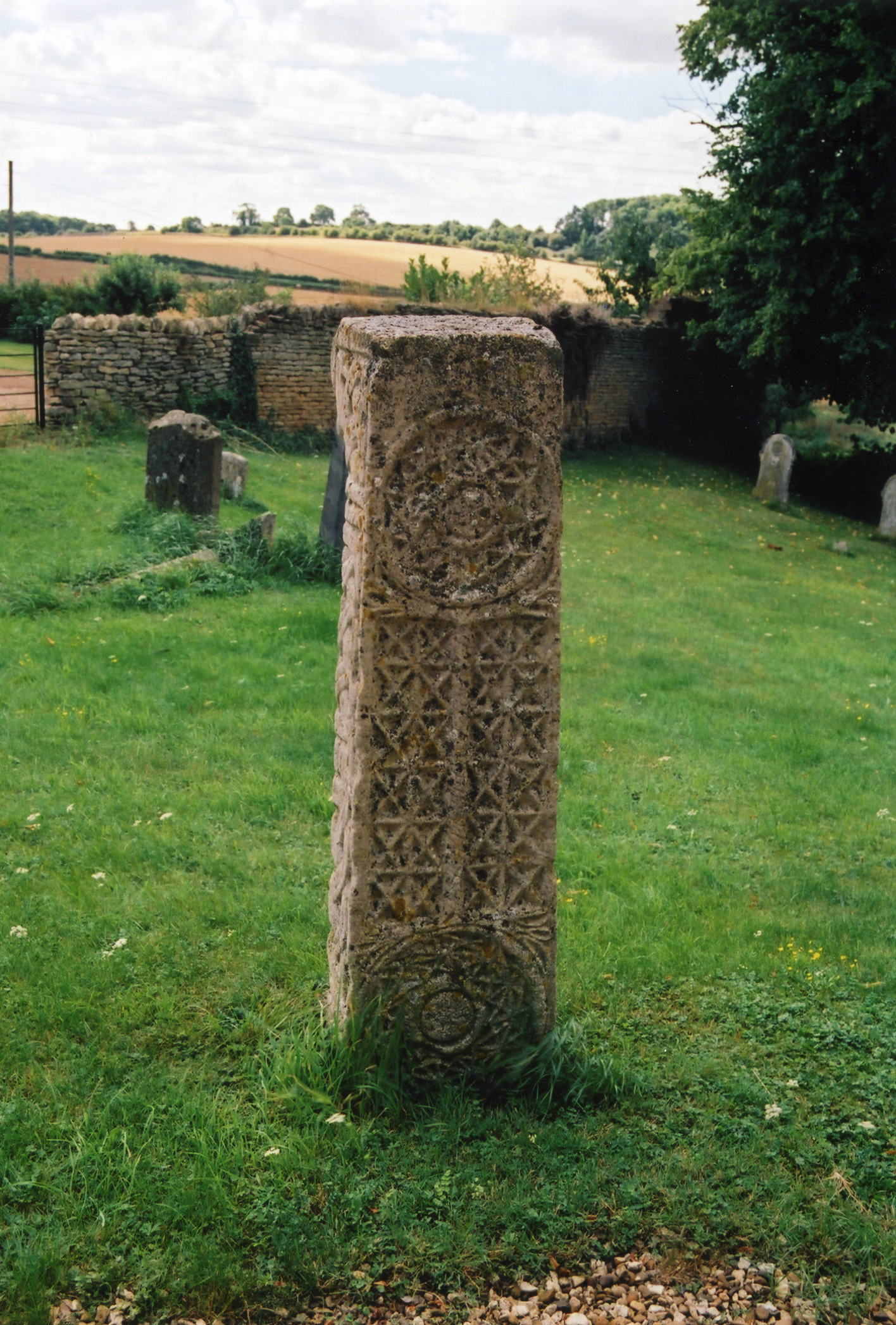
- There are traces of a Saxon cross in the graveyard.
- Bob HARVEY has a photograph of that Saxon Cross on Geo-graph, taken in April, 2010.
- Richard CROFT has a photograph of the churchyard on Geo-graph, taken in April, 2014.
| St Peter, Creeton, Church of England |
- The parish was in the Corby sub-district of the Bourne Registration District.
- Check our Census Resource page for county-wide resources.
- The table below gives census piece numbers, where known:
Census
YearPiece No. 1841 H.O. 107 / 616 1851 H.O. 107 / 2095 1861 R.G. 9 / 2315 1871 R.G. 10 / 3311 1881 R.G. 11 / 3195 1891 R.G. 12 / 2555
| St Peter, Creeton, Church of England |
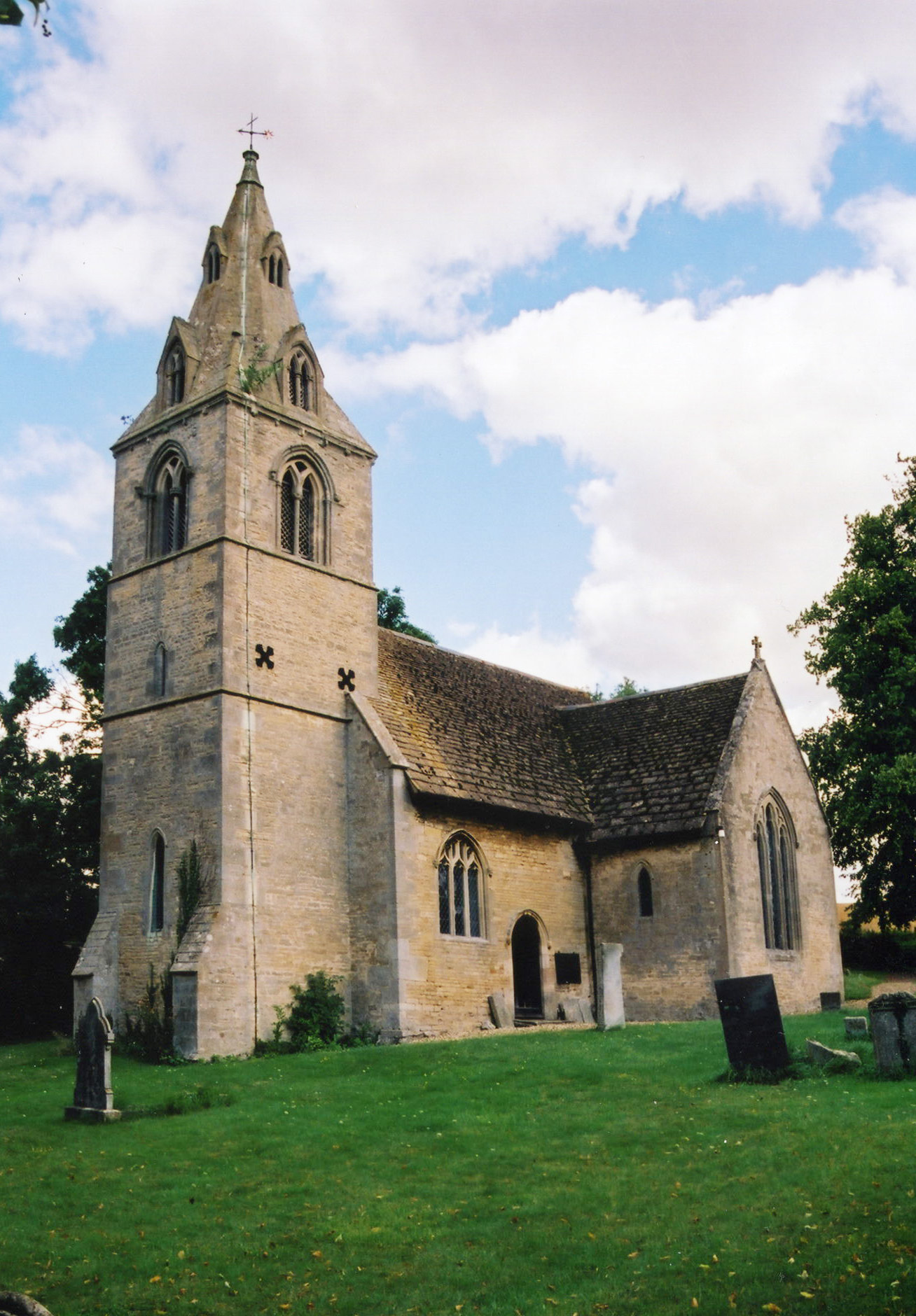
- The Anglican parish church is dedicated to Saint Peter.
- The church was thoroughly restored in 1851.
- The church was partially rebuilt in 1853.
- The church seats 100.
- Tim HEATON has a photograph of St. Peter's Church on Geo-graph, taken in December, 2006.
- Richard CROFT has a photograph of the church interior on Geo-graph, taken in March, 2010.
- Here are two photographs of St. Peter's Church supplied by Ron COLE (who retains the copyright):
- The Anglican parish registers exist from 1692, although Bishop's transcripts go back to 1561.
- The parish lies in the Beltisloe Deanery, for which several marriage indexes exist.
- Check our Church Records page for county-wide resources.
- The parish was in the Corby sub-district of the Bourne Registration District.
- Check our Civil Registration page for sources and background on Civil Registration which began in July, 1837.
This village, township and parish lie along the West Glen River about 8 miles north of Stamford and almost 4 miles south of Corby parish. It lies between Castle Bytham to the southwest and Edenham parish to the east. The hamlet of Counthorpe is just west of the village across the railroad tracks and is part of the parish. There are several Counthorpe hamlets in this part of Lincolnshire.
The parish encompasses only 1003 acres. There are forested areas east of the village which include a deer park. If you are planning a visit:
- The village has its own Information Portal telling you what is going on in the area.
- By automobile: the B1176 trunk road bisects the parish.
- Robert HARVEY has a photograph of the West Glen river on Geo-graph, taken in November, 2019.
- The London-Edinburgh railway line bisects the parish. Andrew TATLOW has a photograph of the East Coast Main Line bridge at Creeton on Geo-graph, taken in July, 2020.
- See our touring page for visitor services.
- Ask for a calculation of the distance from Creeton to another place.
- The quarry in Creeton parish extracts Jurassic limestone. It is also the site of ancient iron smelting, perhaps by the Romans.
- Bob HARVEY has a photograph of the medieval shrunken village area on Geo-graph, taken in March, 2014.
- Rex NEEDLE has a photograph of the 1999 flood on Geo-graph, taken in March, 1999.
- See our Maps page for additional resources.
You can see maps centred on OS grid reference TF015199 (Lat/Lon: 52.76717, -0.497084), Creeton which are provided by:
- OpenStreetMap
- Google Maps
- StreetMap (Current Ordnance Survey maps)
- Bing (was Multimap)
- Old Maps Online
- National Library of Scotland (Old Ordnance Survey maps)
- Vision of Britain (Click "Historical units & statistics" for administrative areas.)
- English Jurisdictions in 1851 (Unfortunately the LDS have removed the facility to enable us to specify a starting location, you will need to search yourself on their map.)
- Magic (Geographic information) (Click + on map if it doesn't show)
- GeoHack (Links to on-line maps and location specific services.)
- All places within the same township/parish shown on an Openstreetmap map.
- Nearby townships/parishes shown on an Openstreetmap map.
- Nearby places shown on an Openstreetmap map.
The Imperial War Museum tells us that there is a Memorial Arch in the church for all those who died in World War One and World War Two. The only name listed is for Corporal COVRLEY, below.
There is a photograph of the memorial plaque and the single name on it at the Roll of Honour site.
Corporal Leslie Haden COVERLEY, the son of Thomas Tobias and Ellen Elizabeth COVERLEY of Counthorpe, died in June 1944 while serving with the East Surrey Regt.
- The name Creeton is from the Old English Creata+tun, or "farmstead of a man called Creata". In the 1086 Domesday Book, the village name is given as Cretone.
[A. D. Mills, "A Dictionary of English Place-Names," Oxford University Press, 1991].
- This place was an ancient parish in Lincoln county and became a modern Civil Parish when those were established.
- The parish was in the ancient Beltisloe Wapentake in the South Kesteven district in the parts of Kesteven.
- In 1860, Counthorpe, formerly a hamlet to Castle Bytham, was annexed to Creeton parish.
- In April, 1931, the existing Civil Parish was abolished to create a new Civil Parish of Counthorpe and Creeton.
- The citizens of this parish have elected to forgo a formal parish council. Instead, they hold periodic Parish Meetings to discuss civic or political issues, but they are NOT staffed or funded to help you with family history searches.
- For today's district governance, contact the South Kesteven District Council.
- Bastardy cases would be tried in the Bourne Petty Session hearings.
- As a result of the 1834 Poor Law Amendment Act, the parish of Creeton became part the Bourne Poor Law Union.
- The children of Creeton attended school in Counthorpe in the 19th century, but now attend school south of town at a facility halfway to Little Bytham.
- Rex NEEDLE has a photograph of the school at Little Bytham on Geo-graph, taken in June, 2000. Tha caption touches on a historical note.
- Creeton village formed a School Board district which also included Little Bytham and Counthorpe.
- Andrew TATLOW has a photograph of the Railway Children's Day Nursery in Creeton on Geo-graph, taken in July, 2020.
- For more on researching school records, see our Schools Research page.