
Hide
Croxton
hide
Hide
hide
Hide
hide
Hide
Hide
Hide
The Brigg Library is an excellent resource with a Local History section.
- The parish was in the Brigg sub-district of the Glanford Brigg Registration District.
- Check our Census Resource page for county-wide resources.
- The table below gives census piece numbers, where known (contributed by Keith DOREY):
| Census Year | Piece No. |
|---|---|
| 1841 | H.O. 107 / 631 |
| 1851 | H.O. 107 / 2116 |
| 1861 | R.G. 9 / 2399 |
| 1871 | R.G. 10 / 3430 |
| 1881 | R.G. 11 / 3285 |
| 1891 | R.G. 12 / 2626 & 2629 |
| 1901 | R.G. 13 / 3103 |
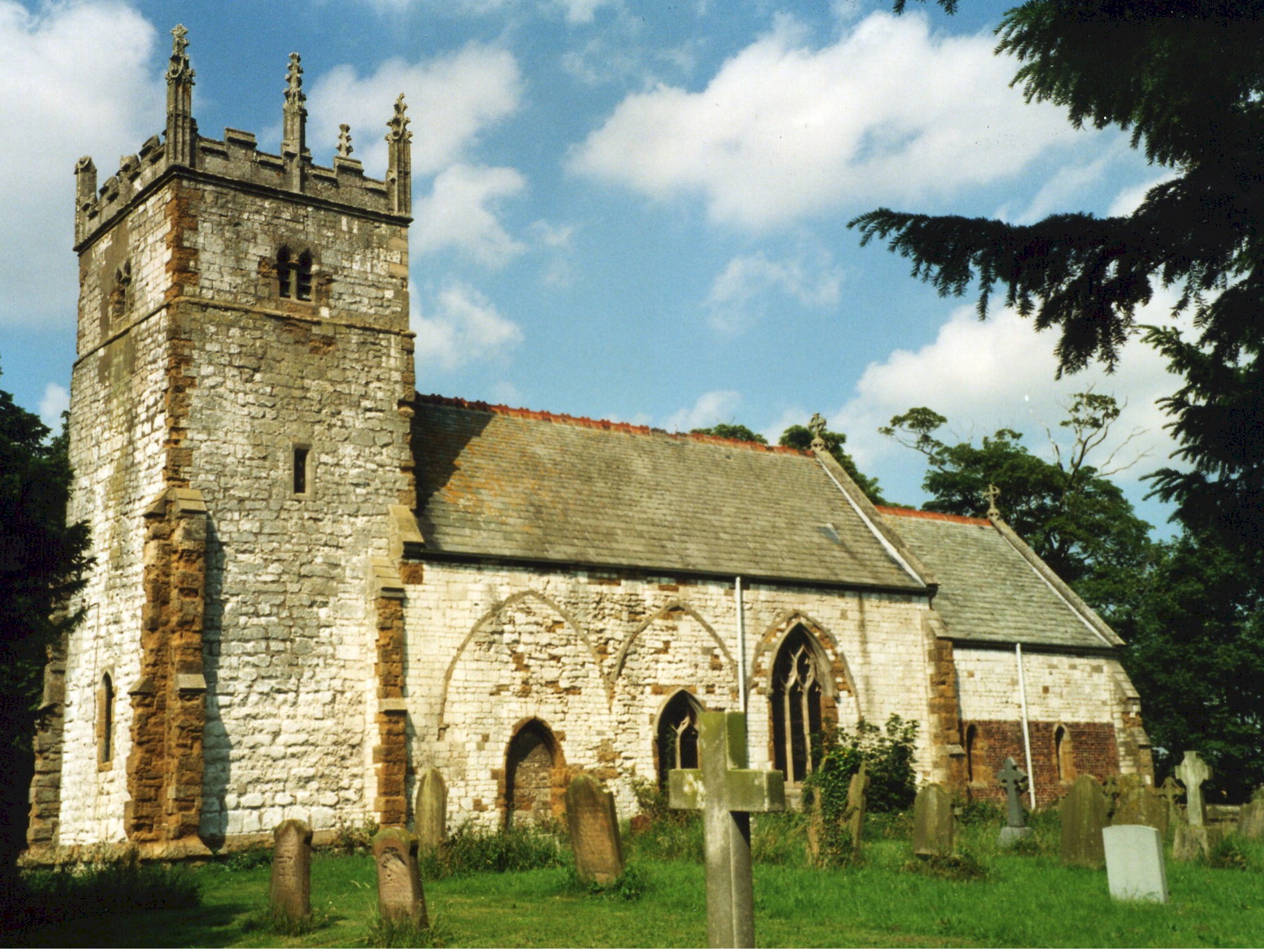
- The Anglican parish church is dedicated to Saint John the Evangelist.
- The church was built in the 13th century. The present building may be the second church built on this site.
- The church was restored about 1878 and seats 90 people.
- There is a photograph of the Anglican parish church on the Wendy PARKINSON Church Photos web site.
- Richard CROFT has a photograph of St. John's Church on Geo-graph, taken in March, 2006.
- Here is a photograph St. John's Church supplied by Ron COLE (who retains the copyright):
- The Anglican parish register dates from 1562.
- There is a monument in the churchyard to Joseph WILSON who died between the first and second Boer Wars. We do not believe this is a war monument.
- The Lincolnshire FHS has published several marriage indexes and a burial index for the Yarborough Deanery to make your search easier.
- Check our Church Records page for county-wide resources.
- The parish was in the Brigg sub-district of the Glanford Brigg Registration District.
- Check our Civil Registration page for sources and background on Civil Registration which began in July, 1837.
Croxton (or Cruxton) is located about 165 miles north of London and 7 miles north-east of Brigg. Ulceby parish is to the north-east. The parish covers just over 1,500 acres.
If you are planning a visit:
- The village and parish are just a mile north of the Humberside International Airport.
- By automobile, take the M180 motorway east out of Brigg or the A180 trunk road west out of Grimsby.
- Visit our touring page for more sources.
- Ask for a calculation of the distance from Croxton to another place.
- "Yarborough Camp" is a large entrenchment on an elevation near the village. Roman coins have been found on the spot.
- In 1930 a large part of the parish was woodland.
- See our Maps page for additional resources.
You can see maps centred on OS grid reference TA094124 (Lat/Lon: 53.596763, -0.348422), Croxton which are provided by:
- OpenStreetMap
- Google Maps
- StreetMap (Current Ordnance Survey maps)
- Bing (was Multimap)
- Old Maps Online
- National Library of Scotland (Old Ordnance Survey maps)
- Vision of Britain (Click "Historical units & statistics" for administrative areas.)
- English Jurisdictions in 1851 (Unfortunately the LDS have removed the facility to enable us to specify a starting location, you will need to search yourself on their map.)
- Magic (Geographic information) (Click + on map if it doesn't show)
- GeoHack (Links to on-line maps and location specific services.)
- All places within the same township/parish shown on an Openstreetmap map.
- Nearby townships/parishes shown on an Openstreetmap map.
- Nearby places shown on an Openstreetmap map.
- This place was an ancient parish in Lincolnshire and became a modern Civil Parish when those were established.
- For governance, the parish was in the ancient Yarborough Wapentake in the Glanford (or North Lindsey) district in the parts of Lindsey.
- Croxton and Kirmington have a joint Parish Council which you may contact regarding civic or political issues. They are NOT staffed to do family history searches for you.
- For today's district governance, see the North Lincolnshire Council website.
- Bastardy cases would be heard in the Brigg petty session hearings.
- After the Poor Law Amendment Act of 1834, this parish became part of the Glanford Brigg Poor Law Union.
- The children of the parish attended school at Kirmington.
- For more on researching school records, see our Schools Research page.