
Hide
Deeping Fen (Deeping St. Nicholas)
hide
Hide
hide
Hide
hide
Hide
Hide
Hide
The Library at Spalding will prove useful in your research.
The Library at Holbeach may also prove useful in your research.
- Prior to formation as a Civil Parish, this extra-parochial place was in the Bourne Registration District.
- The Lincolnshire Family History Society reports that the parish was in the Stamford Registration District in 1851, but a map shows it clearly in the Bourne Reg. District.
- Prior to 27 May, 1862, the parish was the centre of the Deeping St. Nicholas sub-district of the Bourne Registration District.
- On 27 May, 1862, Deeping Saint Nicholas parish became a sub-district in the Spalding Registration District.
- Check our Census Resource page for county-wide resources.
- The table below shows census piece numbers, where known:
| Census Year | Piece No. |
|---|---|
| 1841 | H.O. 107 / 606 & 617 |
| 1851 | H.O. 107 / 2096 |
| 1861 | R.G. 9 / 2319 |
| 1871 | R.G. 10 / 3325 |
| 1891 | R.G. 12 / 2564 - 2565 |
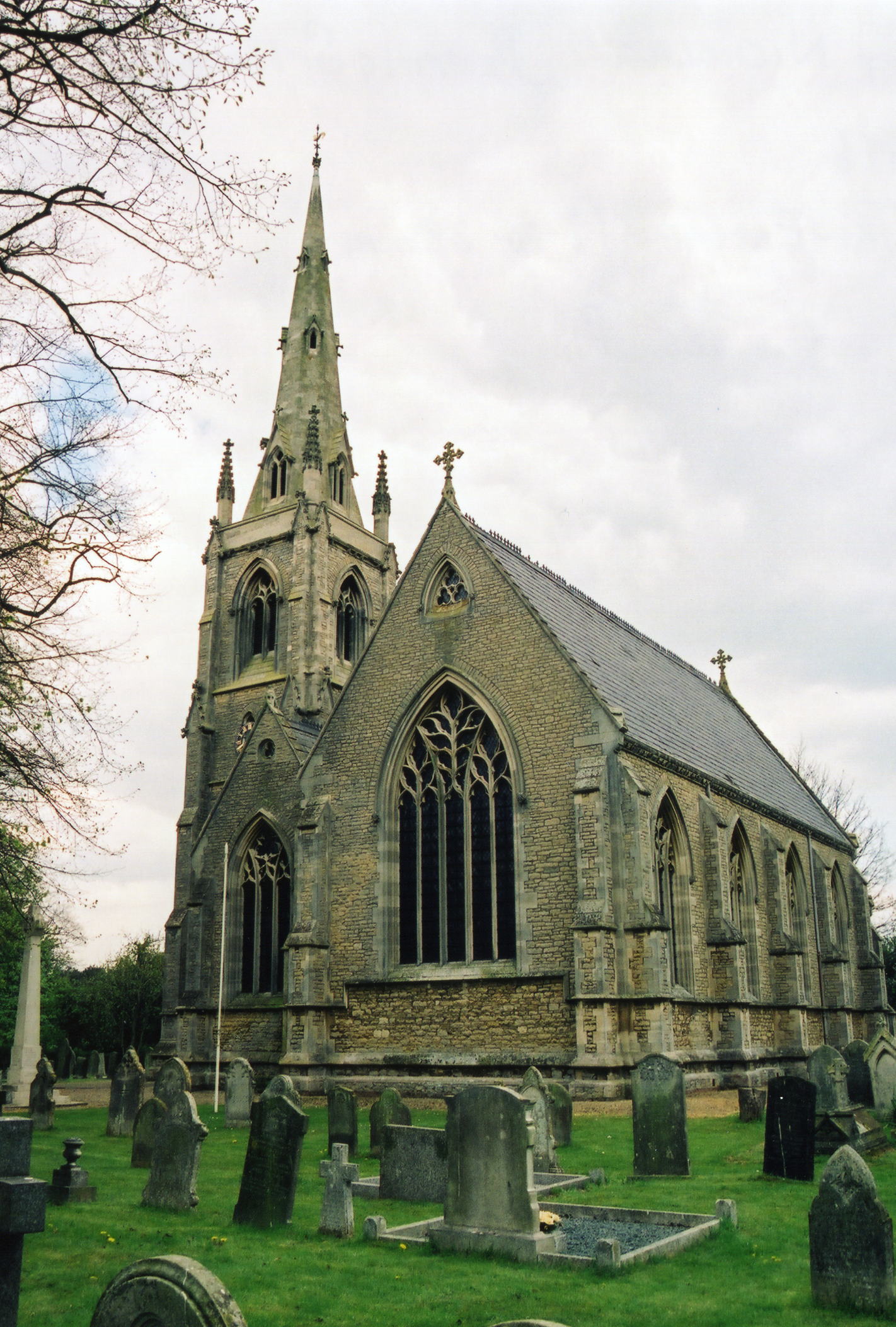
- The Anglican parish church is dedicated to Saint Nicholas.
- St. Nicholas was built in 1845 with an octagonal spire. It was extensively altered in 1891.
- A clock was added to the tower in 1909.
- The church seats 300.
- There is a photograph of St. Nicholas Church on the Wendy PARKINSON Church Photos web site.
- Richard CROFT has a photograph of St. Nicholas Church on Geo-graph taken in March, 2007.
- Here is a photo of the church, taken by Ron COLE (who retains the copyright):
- The Anglican parish register dates from 1846.
- The LFHS has published several marriage and burial indexes for the West Elloe Deanery to make your search easier.
- A Primitive Methodist chapel was opened here in 1867.
- For information and assistance in researching this chapel, see our non-conformist religions page.
- Check our Church Records page for county-wide resources.
- Prior to formation as a Civil Parish, this extra-parochial Chapelry was in the Bourne Registration District.
- Prior to 27 May, 1862, the parish was the centre of the Deeping St. Nicholas sub-district of the Bourne Registration District.
- On 27 May, 1862, Deeping Saint Nicholas parish became a sub-district in the Spalding Registration District.
- Check our Civil Registration page for sources and background on Civil Registration which began in July 1837.
Deeping St. Nicholas (formerly Deeping Fen) is both a village and parish a few miles north of Peterborough. The parish is bounded on the west side, in part, by the River Welland. The town of Spalding is to the north-east and Crowland parish to the south-east. The area is around 15,000 acres of flat fenland, drained by many small canals, including the South Drove Drain.
If you are planning a visit:
- By automobile, the A16 trunk road runs through the village itself.
- See our touring page for more sources.
- Ask for a calculation of the distance from Deeping Fen (Deeping St. Nicholas) to another place.
- Deeping Fen was drained in 1845. The parish lies below sea level.
- The village had a station on the East Lincolnshire branch of the Great Northern railway called Littleworth. The station closed to passenger service around 1960.
- You might be interested in this bit of local history from an 1861 Thunderstorm.
- Tongue End was the site of some Speed Skating events in the early 1800s. The sport dates back to around 1700. The National Skating Association was set up in Cambridge in 1879.
- See our Maps page for additional resources.
You can see maps centred on OS grid reference TF217162 (Lat/Lon: 52.729757, -0.199215), Deeping Fen (Deeping St. Nicholas) which are provided by:
- OpenStreetMap
- Google Maps
- StreetMap (Current Ordnance Survey maps)
- Bing (was Multimap)
- Old Maps Online
- National Library of Scotland (Old Ordnance Survey maps)
- Vision of Britain (Click "Historical units & statistics" for administrative areas.)
- English Jurisdictions in 1851 (Unfortunately the LDS have removed the facility to enable us to specify a starting location, you will need to search yourself on their map.)
- Magic (Geographic information) (Click + on map if it doesn't show)
- GeoHack (Links to on-line maps and location specific services.)
- All places within the same township/parish shown on an Openstreetmap map.
- Nearby townships/parishes shown on an Openstreetmap map.
- Nearby places shown on an Openstreetmap map.
- Richard CROFT has a photograph of the War Memorial outside the church on Geo-graph taken in March, 2007.
- J. THOMAS also has a photograph of the War Memorial on Geo-graph taken in September, 2012.
There is a photograph of the war memorial and the list of the names honoured at the Roll of Honour site.
- The name Deeping is from the Old English Deoping, for "deep or Low place". In the 1086 Domesday book, the village is given as Estdeping.
[A. D. Mills, "A Dictionary of English Place-Names," Oxford University Press, 1991]
- This place was an ancient extra-parochial Chapelry in county Lincoln.
- The ecclesiastical parish was created in 1846, after the land had been drained, and was formed into a Civil Parish in May, 1862.
- The St. Nicholas portion of the parish was in the ancient Elloe Wapentake in the South Holland district in the parts of Holland.
- A portion of the parish was in the ancient Ness Wapentake in the South Holland district in the parts of Holland.
- In April, 1932, the parish gained 1,478 acres and 124 people when part of Spalding Civil Parish was ceded to Deeping St. Nicholas Civil Parish.
- You may contact the local Deeping St. Nicholas Parish Council regarding civil or political issues, but they are NOT staffed to answer family history questions.
- For today's district governance, visit the South Holland District Council site.
- Records indicate that the parish was originally formed in 1846 and reformed in 1856, when it was divided into three townships, North, Middle and East. This "divided" mentality persisted, partly because part of the parish traditionally is in the Kesteven district and part in the Holland district of the county.
- Bastardy cases would be heard in the Elloe (Spalding) petty session hearings.
- As a result of the 1834 Poor Law Amendment Act, the parish became part of the Spalding Poor Law Union.
Year Inhabitants 1801 370 1831 790 1841 973 1871 1,335 1881 1,030 1891 1,325 1901 1,255 1911 1,439 1921 1,540
- A School Board of 5 members was formed in March, 1874 to serve this parish and Deeping St. James.
- Deeping High Bank School in the East Township was built in 1875.
- Littleworth School was built in 1875.
- Tongue End School (mixed) in the North township was built in 1876 for 80 children.
- For more on researching school records, see our Schools Research page.