
Hide
Donington
hide
Hide
hide
Hide
hide
Hide
Hide
Hide
- Donington has its own small Community Library at 25 High Street. It is normally open only on Wednesdays, Fridays and Saturdays.
- Donnylad has a photograph of the Donington Library building on Geo-graph, taken in May, 2006.
- The Library at Spalding will prove useful in your research.
- A Cemetery was set aside by the parish council in 1900. It is just off BICKER Road (The A52).
- The Cemetery was closed for burials in 2000. A "New Cemetery" was laid out off Hunter Way and the cemetery above became the "Old Cemetery".
- You can search for ancestors in the Old Cemetery on Internment.Net.
- You can search for ancestors in the New Cemetery on Internment.Net.
- The parish was in the Donington sub-district of the Spalding Registration District.
- Check our Census Resource page for county-wide resources.
- The table below gives census piece numbers, where known:
| Census Year | Piece No. |
|---|---|
| 1841 | H.O. 107 / 606 |
| 1851 | H.O. 107 / 2096 |
| 1861 | R.G. 9 / 2321 |
| 1871 | R.G. 10 / 3319 |
| 1881 | R.G. 11 / 3201 |
| 1891 | R.G. 12 / 2560 |
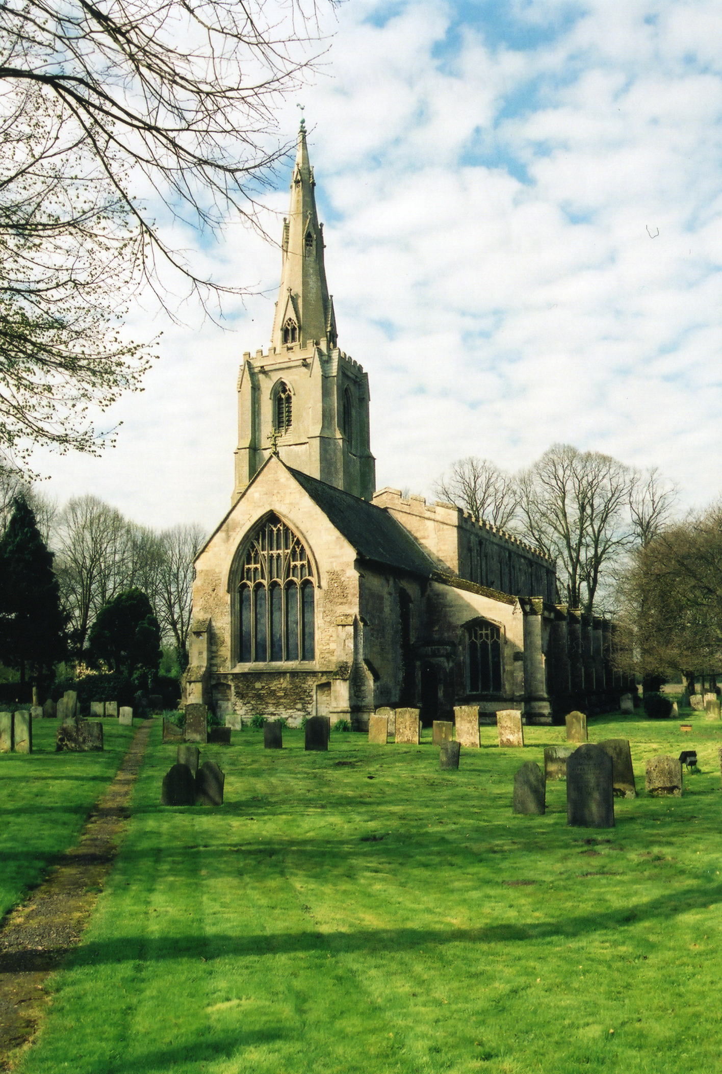
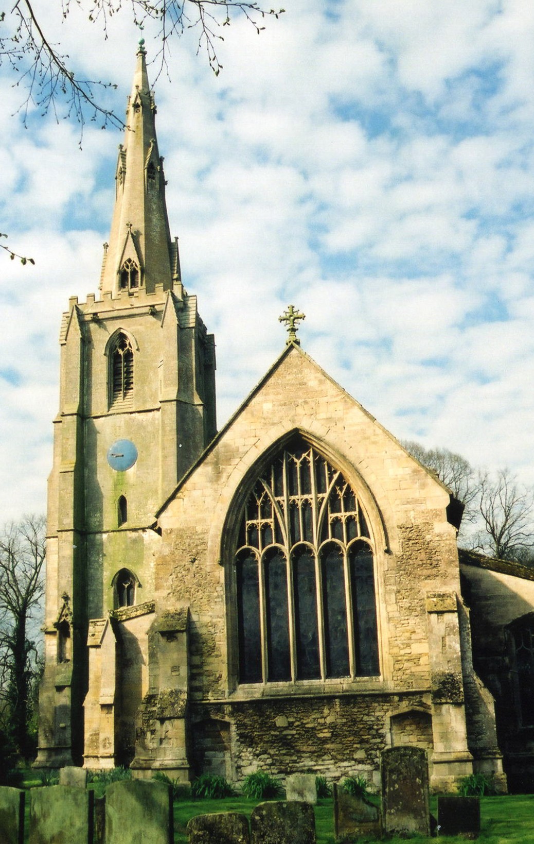
- The Anglican church is dedicated to Saint Mary and the Holy Rood.
- The church is from the 13th century.
- The churchyard was enlarged in 1865.
- The church is a Grade I structure with English Heritage.
- The church seats 743.
- There is a photograph of St. Mary and the Holy Rood Church on the Wendy PARKINSON Church Photos web site.
- J. HANNAN-BRIGGS has a photograph of St. Mary's Church on Geo-graph, taken in January, 2012.
- Here are two photographs of St. Mary's Church, taken by Ron COLE (who retains the copyright):
- There are more photographs in and around the church at the Sheila W. BRUCE web site.
- The Anglican church parish registers exist from 1642.
- The LFHS has published several marriage and burial indexes for the Holland West Deanery.
- The parish boasted chapels for Particular Baptists and for Wesleyan and Primitive Methodists.
- For information and assistance in researching these chapels, see our non-conformist religions page.
- There is a photograph of one of the Methodist chapels on Geo-graph, taken in April, 2007.
- Check our Church Records page for county-wide resources.
- The parish was in the Donington sub-district of the Spalding Registration District.
- Check our Civil Registration page for sources and background on Civil Registration which began in July, 1837.
Donington (sometimes "Donnington") is both a village, a market town and a parish. It lies 110 miles north of London, 10 miles north of Spalding and 10 miles to the southwest of Boston. The parish is bounded on the north by Bicker parish and on the south by Quadring parish. The parish covers over 5,800 acres and includes the hamlet of Northorpe. The area is flat fenland, drained by many small canals.
The nearby "Forty Foot Drain" used to be an important route for barge trade to Boston.
The village lies just off the A52 trunk road. If you are planning a visit:
- The parish is on an operating passenger rail line with stopping services, but has no station.
- See our touring page for visitor services.
- Ask for a calculation of the distance from Donington to another place.
- Market Day used to be held on Saturday and there were agricultural fairs held on May 25th and October 17th.
- Wikes Farm used to be the only Heronry in this part of England. The Herons would arrive in February and depart in September.
- The most famous son of Donington was Capt. Matthew FLINDERS (1775 - 1814). Born in Donington, he died in London. He was the driving force behind getting the name Australia adopted for what was then known as New Holland. He was baptised in Donington on 28 Apr 1774, son of Matthew and Susannah FLINDERS.
- Rodney BURTON has a photograph of Mathew FLINDER's statue on Geo-graph, taken in July, 2006.
- Alex McGREGOR reminds us that even Matthew FLINDERS had to wear a mask during the pandemic. This photo was taken in March, 2021.
- The parish had a railway station on Donington Road. In 1900, Alfred MARJASON was the station master.
- A police station was erected here in 1859. In 1911, inspector John William MOORE ran the station along with one other officer.
- J. THOMAS has a photograph of the Black Swan Public House on Geo-graph, taken in August, 2013. This Pub. is on the High Street (the A152), near the Library.
- The national grid reference is TF 2035.
- You'll want an Ordnance Survey Explorer 249 map, which has a scale of 2.5 inches to the mile.
- See our Maps page for additional resources.
You can see maps centred on OS grid reference TF208359 (Lat/Lon: 52.906963, -0.205257), Donington which are provided by:
- OpenStreetMap
- Google Maps
- StreetMap (Current Ordnance Survey maps)
- Bing (was Multimap)
- Old Maps Online
- National Library of Scotland (Old Ordnance Survey maps)
- Vision of Britain (Click "Historical units & statistics" for administrative areas.)
- English Jurisdictions in 1851 (Unfortunately the LDS have removed the facility to enable us to specify a starting location, you will need to search yourself on their map.)
- Magic (Geographic information) (Click + on map if it doesn't show)
- GeoHack (Links to on-line maps and location specific services.)
- All places within the same township/parish shown on an Openstreetmap map.
- Nearby townships/parishes shown on an Openstreetmap map.
- Nearby places shown on an Openstreetmap map.
- One of the windows in the parish church is a memorial to the men who fell in World War I.
- A local resident, Company Srgt.-Major Charles Ernest STOVIN of the East Yorks Rifles was promoted to Captain in 1916 "for honours in the field". He was to marry in nearby Bicker parish in 1917.
- Donnylad has a photograph of the Market Garden Memorial Oak on Geo-graph, taken in May, 2006. Please take a moment to read the caption.
The Old Cemetery has one Commonwealth War Grave from World War I and 4 from World War II. They are for:
- William Jabez THOMPSON, priv., Austrailian Inf., age 45, died 24 Nov. 1917.
- Harold William DODS, lieut., Scots Guards, age 35, died 18 June 1944.
- Harold FORMAN, priv., RAMC, age 45, died 2 Dec. 1946.
- William Henry PATTISON, petty officer, RN, died 6 Mar. 1945.
- Walter Richard WINDSOR, srgt., RAF Vol Rsv., age 26, died 10 Jan. 1944.
- The name Donington is from the Old English duning+tun, or "Estate of Dunna". In the 1086 Domesday book, the village is given as Duninctune.
[A. D. Mills, "A Dictionary of English Place-Names," Oxford University Press, 1991]
- Locals refer to the village as "Donny".
Chris WILSHAW provides this list of surnames from christenings found in the 1730 parish register:
- ATKINSON
- BATES
- BROUGHTON
- BROWN
- HALL
- POUNDER?
- WRIGHT
Louis R. MILLS provides this list from 1830, 100 years later:
- ADKIN
- ALLYATE
- ASHWELL
- BAKER
- BARNES
- BEDFORD
- BELL
- BENSTEAD
- BOOTHROYD
- BOWLES
- CHEAVIN
- CLIFTON
- COY
- CRAMPTON
- DARBY
- DAY
- EVANS
- FAQUEAGE
- FRANCIS
- FREEDMAN
- GIBBONS
- GREEN
- HICKINBOTTOM
- INGALL
- KEMP
- KEY
- KITCHIN
- LAWRENCE
- LEWIN
- LUMBY
- MACKIN
- METCALF
- MITCHELL
- MOORE
- MOTEALF
- MOTTLEY
- NEWTON
- OATES
- OLIFF
- PITTS
- SERGEANTSON
- SHILCOCK
- SHILOCK
- SHIPTON
- STOUT
- TAWIKS (or TAWLKS)
- TEBB
- THOMPSON
- THORIBY
- THOROGARD
- THOROGOOD
- THORPE
- TREECE
- WADLEY
- WADSLEY
- WALKER
- WELLS
- WEST
- The parish was in the ancient Kirton Wapentake in the South Holland district in the parts of Holland.
- You may contact the Donington Parish Council on Facebook regarding civic or political matters, but they are NOT staffed to help you with family history work.
- For today's district governance, visit the South Holland District Council site.
- Bastardy cases would be heard in the Kirton and Skirbeck petty session hearings (held in the local courthouse the last Thursday of each month).
- The parish was funded for an almshouse, founded by Thomas COWLEY in 1701, but it was never built. The trustees of the money provided weekly stipends to each of sixteen old men and women.
- Six boys were put out to apprentice at age 14 each year. At the expiration of their servitude, each was presented with a gratuity of £8.
- As a result of the 1834 Poor Law Amendment Act reforms, the parish became part of the Spalding Poor Law Union.
- In 1911, a fund set up by Enoch MILLSON produced an income of £350 per year. This money was distributed to the poor in the form of coal, food and pensions.
- The parish contained a Charity School, founded by Thomas COWLEY in 1701.
- Donnylad has a photograph of Thos. Cowley's original Schoolhouse on Geo-graph, taken in May, 2006.
- Thos. COWLEY also created a Grammar School in 1719. That is now Thomas Cowley High School, whose most famous student was Matthew FLINDERS.
- For more on researching school records, see our Schools Research page.