
Hide
Dunston
hide
Hide
hide
Hide
hide
Hide
Hide
Hide
The Lincoln City Library is an excellent resource with a Local History section and a Family History section.
| St Peter, Dunston, Church of England |
- The parish was in the South West sub-district of the Lincoln Registration District.
- Check our Census Resource page for county-wide resources.
- The table below gives census piece numbers, where known:
| Census Year | Piece No. |
|---|---|
| 1841 | H.O. 107 / 617 |
| 1851 | H.O. 107 / 2104 |
| 1861 | R.G. 9 / 2356 |
| 1871 | R.G. 10 / 3368 |
| 1891 | R.G. 12 / 2588 |
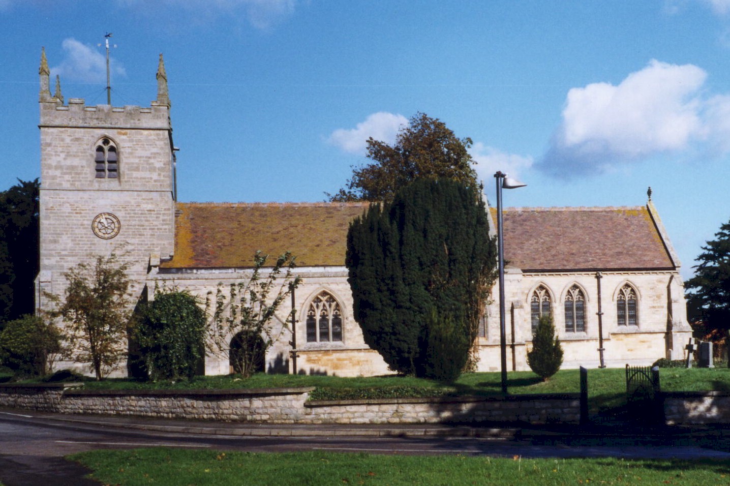
- The Anglican parish church is dedicated to Saint Peter and appears to date from the 13th century.
- The church was rebuilt in 1874, with the exception of the tower. The church was reconsecrated in February, 1876.
- The Anglican parish churchyard was enlarged in 1890 and again in 1910.
- The church seats 250.
- There is a photograph of St. Peter's Church on the Wendy PARKINSON Church Photos web site.
- Here is a photo of St. Peter's Church, taken by Ron COLE (who retains the copyright):
- The Anglican parish register dates from 1564.
- The Lincolnshire FHS has published several marriage indexes and a burial index for the Graffoe Deanery to make your search easier.
- There were chapels here for the Wesleyan Methodists, the Primitive Methodists and the Wesleyan Reform Methodists. For information and assistance in researching these chapels, see our non-conformist religions page.
- Check our Church Records page for county-wide resources.
- The parish was in the South West sub-district of the Lincoln Registration District.
- Check our Civil Registration page for sources and background on Civil Registration which began in July, 1837.
Dunston is a village and a large parish a few miles southeast of Lincoln in Lincolnshire, just south of Nocton parish. Metheringham parish is to the south. The parish covers almost 3,400 acres.
If you are planning a visit:
- Richard CROFT has a photograph of the Dunston Brook at Geo-graph, taken in 2007.
- By automobile, take the B1198 trunk road, south out of Lincoln. Just past Nocton, about a mile further on, the village will be to your left, just off the road.
- For bus service, check Lincsbus Info.
- See our touring page for more sources.
- Ask for a calculation of the distance from Dunston to another place.
- Dunston had an "inland lighthouse," one of the few in England. There is more information on the Dunston Pillar page.
- Richard CROFT has a photograph of the Red Lion Public House at Geo-graph, taken in 2008. The Red Lion has been in operation for over 100 years.
- The Red Lion has its own website but no history!
- These are the names associated with the Red Lion in various directories:
| Year | Person |
|---|---|
| 1842 | Thomas ELVIDGE, vict. |
| 1856 | Thomas RAWSON, butcher and vict. |
| 1872 | John RICHARDSON, butcher and victualler |
| 1882 | John RICHARDSON, victualler |
| 1900 | Joseph PARSONS |
| 1913 | Joseph PARSONS |
| 1930 | Joseph PARSONS |
- See our Maps page for additional resources.
You can see maps centred on OS grid reference TF065630 (Lat/Lon: 53.153668, -0.409412), Dunston which are provided by:
- OpenStreetMap
- Google Maps
- StreetMap (Current Ordnance Survey maps)
- Bing (was Multimap)
- Old Maps Online
- National Library of Scotland (Old Ordnance Survey maps)
- Vision of Britain (Click "Historical units & statistics" for administrative areas.)
- English Jurisdictions in 1851 (Unfortunately the LDS have removed the facility to enable us to specify a starting location, you will need to search yourself on their map.)
- Magic (Geographic information) (Click + on map if it doesn't show)
- GeoHack (Links to on-line maps and location specific services.)
- All places within the same township/parish shown on an Openstreetmap map.
- Nearby townships/parishes shown on an Openstreetmap map.
- Nearby places shown on an Openstreetmap map.
- This place was an ancient parish in county Lincoln and became a modern Civil Parish when those were established.
- The parish was in the second division of the ancient Langoe Wapentake in the North Kesteven division of the county, in the parts of Kesteven.
- You may contact the local Parish Council regarding civic or political issues, but they are NOT staffed to assist you with family history searches.
- For today's district governance, see the North Kesteven District Council.
- Bastardy cases would be heard at the Lincoln South petty session hearings.
- As a result of the Poor Law Amendment Act reforms of 1834, the parish became part of the Lincoln Poor Law Union.
- A Public Elementary School was erected here in 1852 and later enlarged. It was enlarged again in 1890 to hold up to 135 children.
- Richard CROFT has a photograph of this old school at Geo-graph, taken in 2007.
- For more on researching school records, see our Schools Research page.