
Hide
Farforth
hide
Hide
hide
Hide
hide
Hide
Hide
hide
Hide
Hide
The Library at Louth will prove useful in your research.
- Chris ? has a photograph of some of the gravestones at St. Peter's churchyard on Geo-graph, taken in August, 2013.
- Chris ? also has a photograph of the gravestone of Henry Charles ALLENBY who died at age 22 from drowning on Geo-graph, taken in August, 2013.
- Henry Charles ALLENBY was buried 3 June 1822 at Farforth. He was "possibly" the sone of Samuel ALLENBY who was buried here in 1824.
- The parish was in the Louth sub-district of the Louth Registration District.
- Check our Census Resource page for county-wide resources.
- The table below gives census piece numbers, where known:
| Census Year | Piece No. |
|---|---|
| 1841 | H.O. 107 / 633 |
| 1851 | H.O. 107 / 2111 |
| 1861 | R.G. 9 / 2381 |
| 1871 | R.G. 10 / 3404 |
| 1891 | R.G. 12 / 2608 |
| 1901 | R.G. 13 / 3084 |
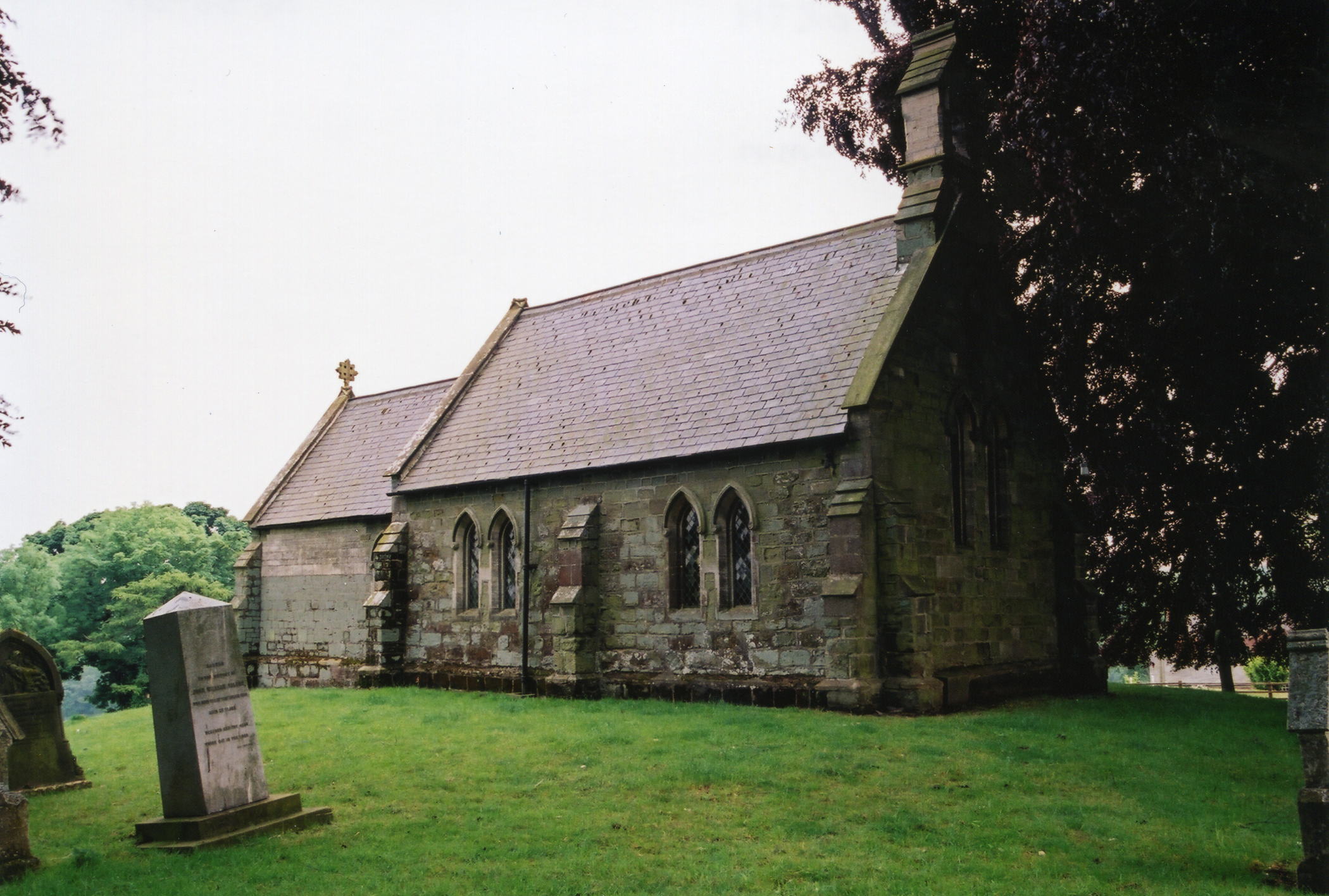
- The Anglican parish church is dedicated to Saint Peter.
- There was an earlier church here, but it was torn down prior to 1861.
- The church was rebuilt in Early English style in 1861 of stones from the original structure. The church was renovated in 1904.
- The church seats 80.
- The church is a Grade II structure with English Heritage.
- There is a photograph of St. Peter's Church on the Wendy PARKINSON web site under "Yet More Lincolnshire".
- Here is a photo of St. Peter's Church, taken by Ron COLE (who retains the copyright):
- The Anglican parish register dates from 1784.
- The LFHS has published several marriage indexes for the Bolingbroke Deanery to make your search easier.
- Check our Church Records page for county-wide resources.
- The parish was in the Louth sub-district of the Louth Registration District.
- Check our Civil Registration page for sources and background on Civil Registration which began in July, 1837.
Farforth is both a village and a parish 6 miles south of Louth. The parish covers almost 2,000 acres and includes the hamlet of Maidenwell.
If you are planning a visit:
- Visit our touring page for more sources.
- Ask for a calculation of the distance from Farforth to another place.
- See our Maps page for additional resources.
You can see maps centred on OS grid reference TF320794 (Lat/Lon: 53.295556, -0.020962), Farforth which are provided by:
- OpenStreetMap
- Google Maps
- StreetMap (Current Ordnance Survey maps)
- Bing (was Multimap)
- Old Maps Online
- National Library of Scotland (Old Ordnance Survey maps)
- Vision of Britain (Click "Historical units & statistics" for administrative areas.)
- English Jurisdictions in 1851 (Unfortunately the LDS have removed the facility to enable us to specify a starting location, you will need to search yourself on their map.)
- Magic (Geographic information) (Click + on map if it doesn't show)
- GeoHack (Links to on-line maps and location specific services.)
- All places within the same township/parish shown on an Openstreetmap map.
- Nearby townships/parishes shown on an Openstreetmap map.
- Nearby places shown on an Openstreetmap map.
- This place was an ancient parish in Lincolnshire, but only became a modern Civil Parish in 1936.
- The parish was in the Wold division of the ancient Louth Eske Wapentake in the East Lindsey district in the parts of Lindsey.
- This parish was incorporated as a modern Civil Parish under the name "Maidenwell Civil Parish" in 1936.
- This citizens of this parish have elected to forgo a formal Parish Council, but do hold periodic Parish Meetings to dicuss civic and political issues.
- For today's district governance, see the East Lindsey District Council.
- Bastardy cases would be heard in the Louth petty session hearings in the Louth Courthouse every other Wednesday.
- In 1719 Mr. Charles HUMPHREY left the interest of £15 for the poor. (Some sources say only 15 Shillings per year.)
- After the 1834 Poor Law Amendment Act reforms, the parish became part of the Louth Poorlaw Union.
- A School Board was formed in 1885 for the united parishes of Farforth, Oxcombe and Ruckland.
- A Public Elementary School was built here in 1887 for up to 42 children.
- For more on researching school records, see our Schools Research page.