
Hide
Foston
hide
Hide
Caution: There is a "Foston on the Wolds" in Yorkshire's East Riding that is sometimes mistaken for this parish.
Hide
hide
Hide
hide
Hide
Hide
Hide
The Library at Newark will prove useful in your research.
The Library at Grantham would be second on my list for libraries.
Jonathan THACKER has a photograph of some Slate headstones in Foston churchyard on Geo-graph, taken in March, 2016.
Richard FROFT also noticed some interesting slae headstones. His photograph of the headstones is on Geo-graph, taken in January, 2008.
| St Peter, Foston, Church of England |
- The parish was in the Bennington sub-district of the Newark Registration District.
- Check our Census Resource page for county-wide resources.
- The table below gives census piece numbers, where known:
| Census Year | Piece No. |
|---|---|
| 1841 | H.O. 107 / 618 |
| 1861 | R.G. 9 / 2481 |
| 1881 | R.G. 11 / 3378 |
| 1891 | R.G. 12 / 2715 |
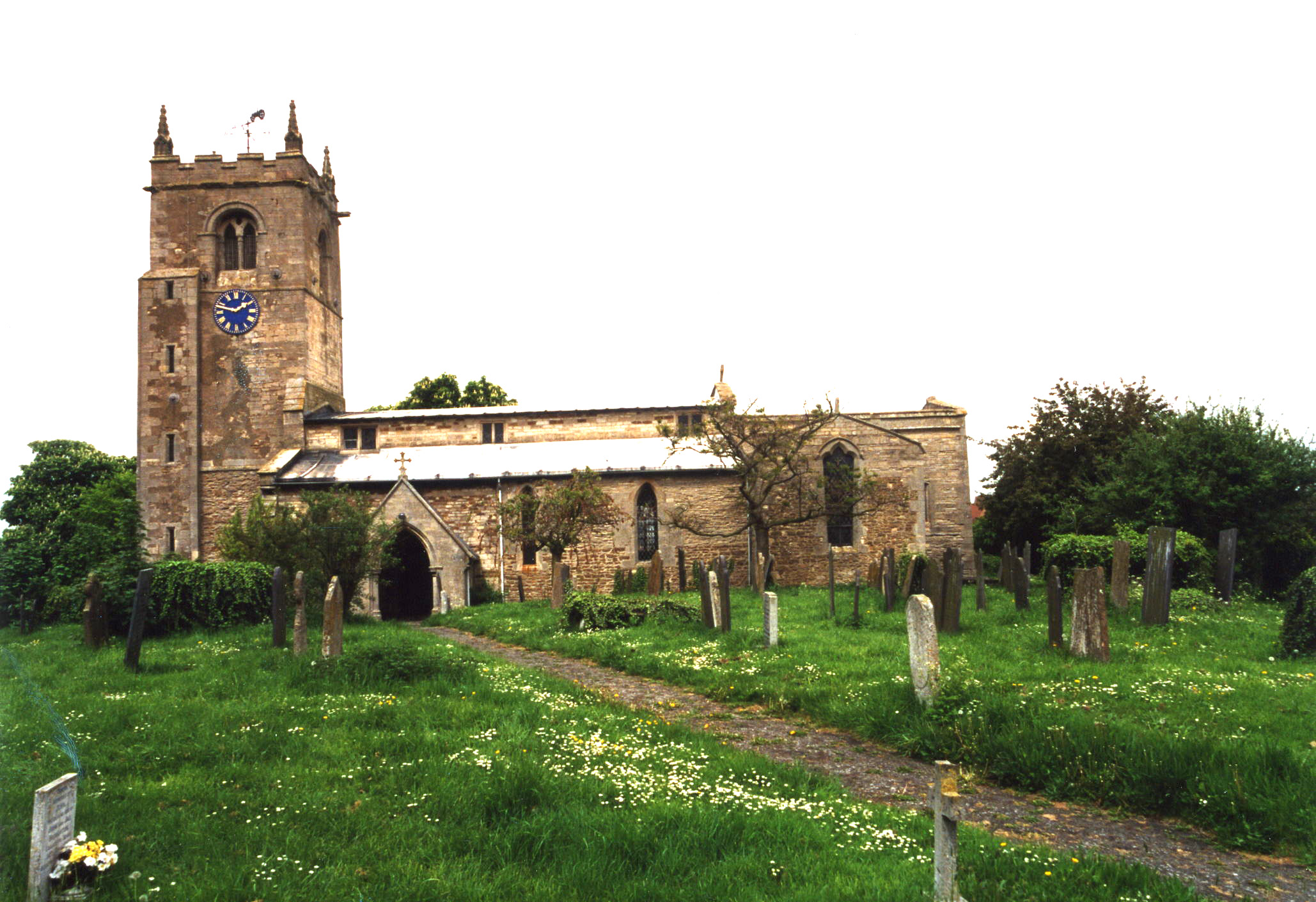
| St Peter, Foston, Church of England |
- The Anglican parish church is dedicated to Saint Peter.
- The church dates back to Norman times, but the construction date is unreported. The church was here by the 13th century and is believed to be from the 10th century.
- The north side was rebuilt in 1858.
- The church is a Grade I listed building by Brisith Heritage.
- The church seats about 300.
- A photograph of St. Peter's church is at the Wendy PARKINSON English Church Photographs site.
- Here is a photo of St. Peter's church, taken by Ron COLE (who retains the copyright):
- The parish registers for burials and baptisms exist from 1626. Marriages were included in Long Bennington's register until 1766.
- Parish registers are on file at the Society of Genealogists, covering 1646 - 1837.
- There are a handful of par. reg. entries in our Parish Register Extract. Please submit additional ones to expand it.
- Boyd's Marriage Index holds marriages from 1651 to 1837, and Pallot's Marriage Index covers 1790 - 1837.
- The LFHS has published several marriage indexes for the Grantham Deanery to make your search easier.
- The Wesleyan Methodists had a chapel here prior to 1910. This chapel was eventually taken down and replaced by bungalows and houses. For information and assistance in researching this chapel, see our non-conformist religions page.
- Check our Church Records page for county-wide resources.
- The parish was in the Bennington sub-district of the Newark Registration District.
- Check our Civil Registration page for sources and background on Civil Registration which began in July, 1837.
Foston is both a village and a parish nearly 6 miles northwest of Grantham, lying just south of the River Witham. Long Bennington parish lies to the west, Westborough parish to the north, and Marston parish lies to the east. The parish covers about 2,100 acres. The Foston Beck (stream) completes the eastern border.
If you are planning a visit:
- By automobile, take the A1 trunk road west out of Grantham (toward Newark-on-Trent). The road passes just south of the village.
- Check out the Foston Village web site for current events.
- Remember to stop by Foston Village Hall on Church Street to check their schedule f forth-coming events.
- Visit our touring page for more sources.
- Ask for a calculation of the distance from Foston to another place.
- There was a settlement here in Roman times. A Roman villa was excavated here between 1891 and 1896.
- It is believed that the Saxons settled here, based on both the village name and the artifacts found on nearby Loveden Hill just east of the village.
- In 1643, during the English Civil War, a battle was fought on Gonerby Moor, between Foston and Marston.
- The Foston post windmill dated from 1624. Alas, it was demolished in 1966.
- Check the history of the Wapentake at the Loveden Wapentake website.
- Jonathan THACKER has a photograph of the former Black Horse Inn on Geo-graph, taken in March, 2016.
- Foston was part of the manor of Long Bennington from Feudal times.
- You might enjoy this notice from the 1836 Stamford Mercury contributed by Eric Hollis.
- In 1871, much of the land in the parish was owned by the Earl of Dysart, J. E. WELBY, but several smaller owners had parcels here.
- The Earl was still the principal landowner in 1913, but additional smallholders could be found.
- See our Maps page for additional resources.
You can see maps centred on OS grid reference SK859430 (Lat/Lon: 52.977175, -0.722523), Foston which are provided by:
- OpenStreetMap
- Google Maps
- StreetMap (Current Ordnance Survey maps)
- Bing (was Multimap)
- Old Maps Online
- National Library of Scotland (Old Ordnance Survey maps)
- Vision of Britain (Click "Historical units & statistics" for administrative areas.)
- English Jurisdictions in 1851 (Unfortunately the LDS have removed the facility to enable us to specify a starting location, you will need to search yourself on their map.)
- Magic (Geographic information) (Click + on map if it doesn't show)
- GeoHack (Links to on-line maps and location specific services.)
- All places within the same township/parish shown on an Openstreetmap map.
- Nearby townships/parishes shown on an Openstreetmap map.
- Nearby places shown on an Openstreetmap map.
During WOrld War One, eight men from the village lost their lives in the armed forces.
During WORld War Two, two men were lost during the war.
The Foston War Memorial is a marble plaque in the church. To see it and a list of the names on it, see the Roll of Honour site.
- The name Foston is from the Old Scandinavian Fos+ton, for "farmstead of Fotr", appearing in the 1086 Domesday Book as Foztun.
[A. D. Mills, "A Dictionary of English Place-Names," Oxford University Press, 1991]
- Here's a list of surnames found in White's 1871 Directory: ALCOCK, ASHER, BAILEY, BARKER, BARRAND, BROWN, BULLIMORE, DICKINSON, DOLBY, EMMONDS, FOSTER, FREEMAN, GUY, HALLAM, HOLLIS, HOYES, HUTCHINSON, JOHNSON, KNIGHT, LINNELL, NEAL, ROBINSON, SPEED, WALTON, WARRINER, WHYLEY, WILKINSON, WILLOWS, WINTER and WRATH.
- Kelley's 1913 Directory lists these surnames: BIRKETT, BONNER, BULLIMORE, BURGIN, BURTON, DICKINSON, GIBSON, HARDWICK, HARWOOD, HORTON, HOWITT, HUTCHINSON, JONES, KEMM, KENWORTH, KUPER, MARSTON, MUXLOW, PARKER, ROBERTS, ROBINSON, ROWBOTHAM, RYDER, SPEED, WALTON, WILKINSON, WILLEY, WINTER, WOOD and YOUNG.
- The parish was in the ancient Loveden Wapentake in the South Kesteven division of the county, in the parts of Kesteven.
- You may contact the Foston Parish Council regarding civic or political issues, but they are NOT staffed to assist you with family history searches.
- For today's district governance, contact the South Kesteven District Council.
- Mary WILDMAN left the interest on £3 for the poor.
- A Mr. CAWSON left £3 a year from the rent of two cottages for the poor.
- John GUY established a charity of £100 to provided funds for Foston Church Sunday School.
- The Common Land was enclosed here in 1796.
- Bastardy cases would be heard in the Spittlegate (Grantham) petty session hearings.
- After the Poor Law Amendment Act reforms of 1834, the parish became part of the Newark Poor Law Union.
Year Inhabitants 1801 243 1811 384 1831 393 1841 497 1851 519 1871 441 1881 357 1891 342 1901 297 1911 248 1931 304
- A National School (later a Public Elementary school) was built next to the church in 1847 by subscription to hold 80 children, but attendance was about half that in 1911.
- The parish school was closed in 1987 and school children were sent to Long Bennington thereafter.
- For more on researching school records, see our Schools Research page.