
Hide
Great Ponton
hide
Hide
hide
Hide
hide
Hide
Hide
hide
Hide
Hide
The Library at Grantham will prove useful in your research.
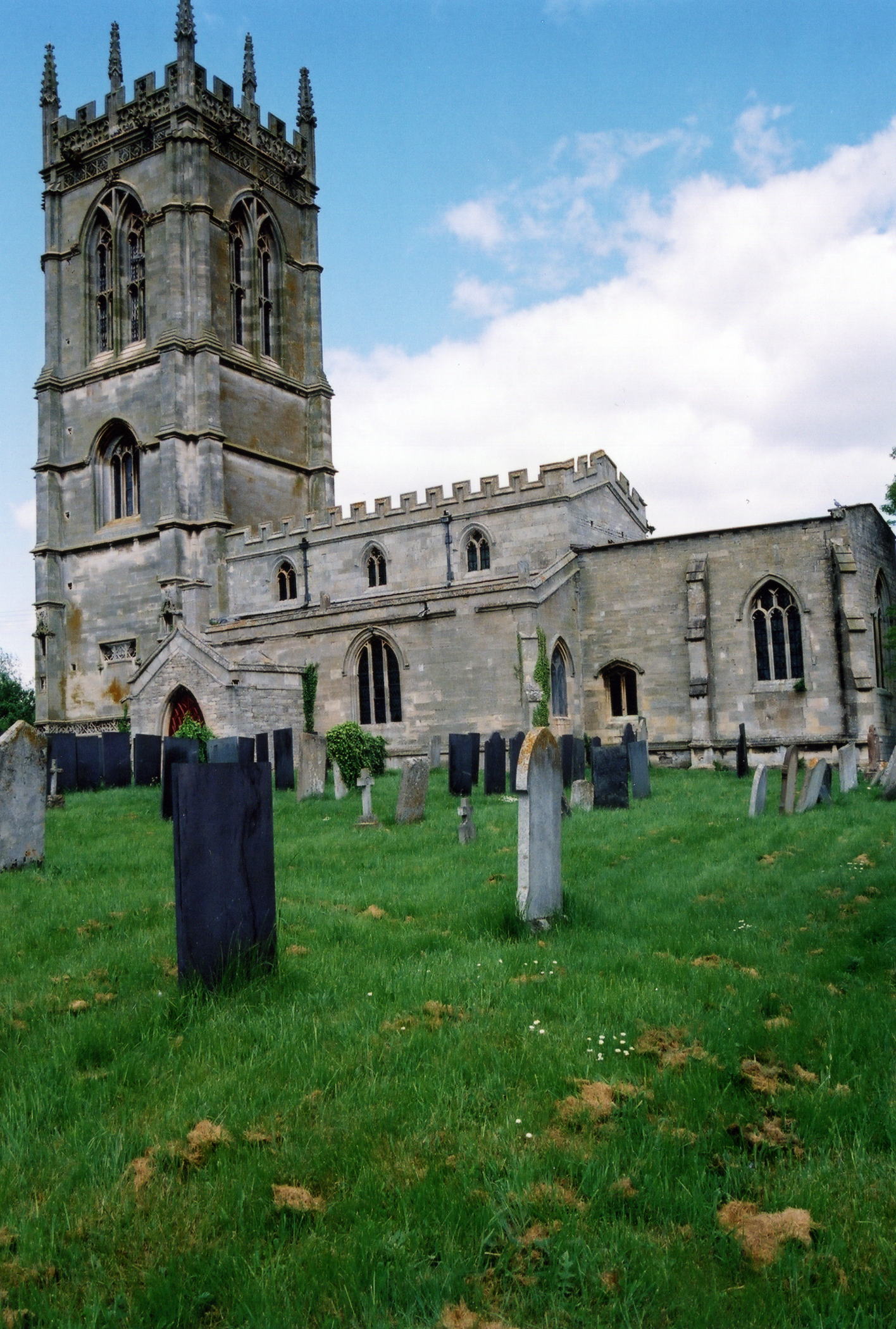
Alexander KAPP provides a photograph of the parish church graveyard on Geograph, taken in 2012.
- The parish was in the Denton sub-district of the Grantham Registration District.
- In an 1891 redistricting, the parish was put in the Grantham South sub-district of the Grantham Registration District.
- Check our Census Resource page for county-wide resources.
- The table below gives census piece numbers, where known:
Census
YearPiece No. 1841 H.O. 107 / 621 1851 H.O. 107 / 2102 1861 R.G. 9 / 2348 1871 R.G. 10 / 3357 1891 R.G. 12 / 2582
| Mill Lane, Great Ponton, Methodist (Primitive) |
| The Terrace, Great Ponton, Methodist (Wesleyan) |
| Providence, Great Ponton, Presbyterian (Calvinistic) |
- The local Anglican church is dedicated to Holy Cross and is said to have been erected in 1519 by Anthony ELLIS. The church structure contains, however, some 14th century work. The tower was designed by Christopher WREN.
- The church seats 200 people.
- The church was re-roofed and restored in 1871.
- Here is a photo of Holy Cross Church, taken by (and copyright of) Ron COLE.
- The Anglican parish register dates from 1622.
- The Family History Library has the parish register on microfilm for 1622 thru 1951 and the Bishop's Transcripts for 1662 thru 1834.
- The Lincolnshire FHS has published several marriage and burial indexes for the Beltisloe Deanery to make your search easier.
- Around 1880, due to the growth of Grantham, the church was moved to the new South Grantham Deanery. Most family records will be found in the Beltisloe Deanery indexes (see above).
- The Wesleyan Methodists built a small chapel here prior to 1842. The Primitive Methodists had one by 1871. For information and assistance in researching these chapels, see our non-conformist religions page.
- Check our Church Records page for county-wide resources.
- The parish was in the Denton sub-district of the Grantham Registration District.
- In an 1891 redistricting, the parish was put in the Grantham South sub-district of the Grantham Registration District.
- Check our Civil Registration page for sources and background on Civil Registration which began in July, 1837.
Great Ponton is both a parish and a small village about 3 miles south of Grantham and 4 miles north of Colsterworth, as well as just over 100 miles north of London. The parish itself is bounded on the north by Stroxton and Little Ponton parishes and to the west by Wyville parish. The parish covered about 2,700 acres in 1842, increased to 2,900 acres by 1881. In 1913, the parish boundaries allowed 2,744 acres.
Great Ponton village is just west of the Witham River. If you are planning a visit:
- Brian GREEN provides his photograph of the River Witham on Geo-org, taken in February, 2008.
- The village can be accessed off of the A1 motorway south of Grantham. The A1 passes through the western edge of the village. Ermine Street, formerly the Great Northern Road and now the B6403 trunk road, passes a mile east of the village.
- Visit our touring page for more sources.
- Ask for a calculation of the distance from Great Ponton to another place.
- The village was occupied by the Romans, at least based on the number of Roman coins, urns, bricks, mosaic pavements, arches, etc. found in the parish. It was reportedly the "Ad Pontem" of the Romans.
- When the railways came in the second half of the 1800s, it bypassed Great Ponton itself. A train station for the Great Northern railway was established just across the River Witham, a mile east of the village, and given the parish name. John BRICE was the station master in 1871 and George FARR in 1881.
- A Miss Ann AYSCOUGH, who died here in 1633, was reportedly 114 years old.
- The village is famous for a violin-shaped weathervane, which has now become the logo for the village.
- The village had an Inn for several centuries. But the Blue Horse Public House was converted into a residence some time after 1913.
- Prior to 1842, part of the ancient Great Ponton Hall remained. It had been the seat and property of the ELLYS and ARCHER families, but had been sold to the Earl Dysart in 1793. It was a farmhouse in 1871.
- The Ellys Manor House, in the heart of Great Ponton, was built in the Flemish style for a Tudor wool merchant. It has early 16th century wall paintings in the upper rooms. It is normally open six days per week for tours, but recently closed. The house is a Grade II listed structure with English Heritage.
- Alexander P. KAPP has a photograph of the Ellys Manor House on Geo-graph, taken in May, 2012.
- See our Maps page for additional resources.
You can see maps centred on OS grid reference SK925304 (Lat/Lon: 52.862912, -0.627165), Great Ponton which are provided by:
- OpenStreetMap
- Google Maps
- StreetMap (Current Ordnance Survey maps)
- Bing (was Multimap)
- Old Maps Online
- National Library of Scotland (Old Ordnance Survey maps)
- Vision of Britain (Click "Historical units & statistics" for administrative areas.)
- English Jurisdictions in 1851 (Unfortunately the LDS have removed the facility to enable us to specify a starting location, you will need to search yourself on their map.)
- Magic (Geographic information) (Click + on map if it doesn't show)
- GeoHack (Links to on-line maps and location specific services.)
- All places within the same township/parish shown on an Openstreetmap map.
- Nearby townships/parishes shown on an Openstreetmap map.
- Nearby places shown on an Openstreetmap map.
William BOADEN has a photograph of the War Memorial on Geo-graph, taken in February, 2015.
For a photograph of the Great Ponton War Memorials and the list of names on them, see the Roll of Honour site.
- The name Ponton presumably comes from the Latin for "bridge," which was "Pontus".
- The village name is often found spelled as Paunton, or the Latin form was used, "Paunton Magna".
- The parish was in the ancient Winnibriggs and Threo Wapentake in the South Kesteven district in the parts of Kesteven.
- The parish was also within the Soke of Grantham.
- You may contact the Parish Council concerning civic or political matters, but they are not staffed nor funded to assist you with family history searches.
- For today's district governance, contact the South Kesteven District Council.
- Bastardy cases would be heard in the Spittlegate (Granthem) petty session hearings.
- At the enclosure of common lands in 1772, about 531 acres were set aside to generate income for the church.
- As a result of the Poor Law Amendment Act reforms of 1834, the parish became part of the Grantham Poor Law Union.
- A Free School was founded here in 1717 by William ARCHER, who endowed it with two cottages and 39 acres of land. Four more acres were added in 1773. New school rooms were built in 1874. It was formally called "Archer's Endowed Church of England School."
- Brian Green has a photograph of the current Church of England School on geo-graph, taken in February, 2008.
- For more on researching school records, see our Schools Research page.