
Hide
Harlaxton
hide
Hide
hide
Hide
hide
Hide
Hide
Hide
The Library at Grantham will prove useful in your research.
Alan MURRAY-RUST has a photograph of five chest tombs in Harlaxton churchyard on Geo-graph, taken in August, 2013.
Trevor RICKARD has a photograph of graves in Harlaxton churchyard on Geo-graph, taken in July, 2012.
- The parish was in the Denton sub-district of the Grantham Registration District.
- In 1891, the parish was placed in the new "Grantham South" sub-district of the Grantham Registration District.
- Check our Census Resource page for county-wide resources.
- The table below gives census piece numbers, where known:
| Census Year | Piece No. |
|---|---|
| 1841 | H.O. 107 / 619 |
| 1851 | H.O. 107 / 2102 |
| 1861 | R.G. 9 / 2349 |
| 1871 | R.G. 10 / 3357 |
| 1891 | R.G. 12 / 2583 |
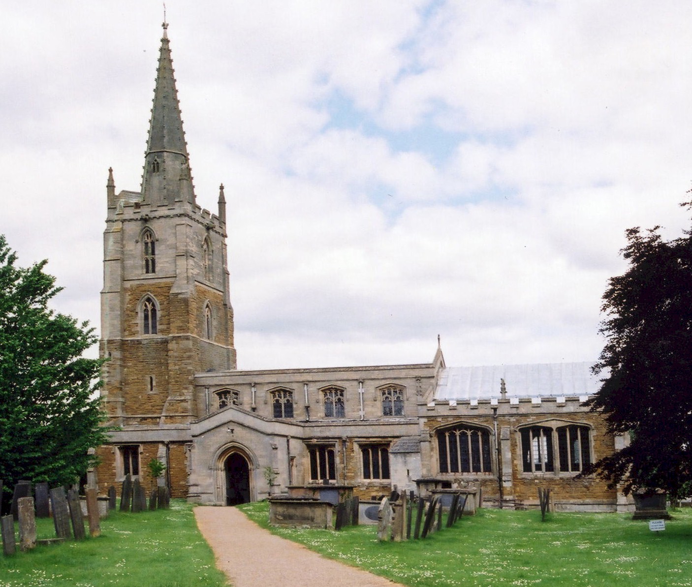
- The Anglican parish church is dedicated to Saint Mary and Saint Peter.
- The church is an ancient structure, parts of which date back to 1323 or earlier.
- The spire was restored in 1885. The inside of the church was renovated in 1890 - 1891.
- The church seats 200.
- J. HANNAH-BRIGGS has a nice photograph of Sts Mary & Peter Church on Geo-graph, taken in March, 2012.
- Richard CROFT has a photograph of the church interior on Geo-graph, taken in April, 2008.
- Here is a photo of St. Mary and St. Peter's Church, taken by Ron COLE (who retains the copyright):
- Parish registers exist from 1558 and include entries from Wyville with Hungerton (to the south) up until 1813. Bishop's Transcripts exist from 1812 to 1843.
- Parish registers for 1558 thru 1808 are also on deposit at the Lincolnshire Archives.
- Parish registers are on file at the Society of Genealogists, covering 1559 - 1837.
- Parish marriages from 1651-1750 are covered in Boyd's Marriage Index, and from 1790-1837 in Pallot's Marriage Index.
- The LFHS has published several marriage and burial indexes for the Grantham Deanery to make your search easier. In the early 1900's, the parish was in the South Grantham Deanery.
- The Wesleyan Methodists had a small chapel here before 1871. Check our Non-Conformist Church Records page for additional resources.
- Check our Church Records page for county-wide resources.
- The parish was in the Denton sub-district of the Grantham Registration District.
- In 1891, the parish was placed in the new "Grantham South" sub-district of the Grantham Registration District.
- Check our Civil Registration page for sources and background on Civil Registration which began in July, 1837.
Harlaxton is both a village and a parish. The parish is about 108 miles north of London and lies about three miles southwest of Grantham on the old Melton Mowbray road (now the A607). The parish itself is bounded on the north by Barrowby and Grantham parishes, to the west by Denton, on the south by Stroxton. The parish covers about 2,700 acres.
The village of Harlaxton is about a half mile south of the Grantham and Nottingham Canal, once a vital part of village commerce. A bridge now crosses the canal to connect Harlaxton to Barrowby. If you are planning a visit:
- It is probably easiest to take the A607 southwest off the A1 Motorway for about two miles.
- Visit Harlaxton Drift (8.36MB of photos) where it runs down to the canal.
- Kate JEWELL has a photograph down Main street on Geo-graph, taken in July, 2005.
- Visit our touring page for more sources.
- Ask for a calculation of the distance from Harlaxton to another place.
- There are monuments and brasses of the DE LIGNE family in the Anglican church dating to 1682 and to the STROOD family in 1498. The GREGORY family, heirs to the DE LIGNE line, are also evident, with items dating to the 1800's.
- In 1740, an urn containing burnt bones and Roman coins was found in the parish.
- John of Gaunt had a hunting seat here. A local plowman unearthed a brass pot which contained a gold and jeweled helmet and it was immediately assumed to be John's. The helmet was presented to Catherine, dowager queen of Henry VIII, who deposited it in the royal cabinet at Madrid.
- A Flower Show is held annually, usually in August, at St. Mary and St. Peter's Church.
- And check the history of the Wapentake at the Loveden Wapentake website (although, oddly, Harlaxton is not noted).
- The Gregory Arms Public House dates back to the 19th century. The parish Squire did not like to see his workers drinking on Sunday, so he moved the pub. to just north of the village and restricted the pub's license to a six-day-a-week certificate. Today they are a Grade II building listed by British Heritage and they operate seven days a week.
- Kate JEWELL has a photograph of The Gregory Arms on Geo-graph, taken in July, 2005.
- This is a nice place to ask about your ancestors These are the names associated with the inn in various directories:
| Year | Person |
|---|---|
| 1842 | -- Not listed -- |
| 1872 | Andrew SCOTT, farmer &emp; victualler |
| 1882 | William TOWERS, coal merchant and victualler |
| 1896 | Henry ALLEN, farmer |
| 1900 | Frank BURTON, farmer |
| 1913 | Herbert CHIPPS |
| 1930 | Herbert CHIPPS |
- In 1871, nearly all of the parish was held by Mrs. Sherwin GREGORY of Harlaxton Manor.
- In 1913, the greater part of the parish was held by Thomas Sherwin PEARSON-GREGORY.
- Harlaxton has a Village Cross, perhaps a Preaching Cross, at the intersection of Church Street and Swine Hill Road. The Cross is largely medieval, Grade II listed by English Heritage and it is a Scehuled Monument. Alex McGREGOR has a photograph of this Village Cross on Geo-graph, taken in November, 2018.
- The original Harlaxton Manor was an ancient structure, built in the valley next to the village and was purchased by the DE LIGNE family around 1475. It was demolished in 1857 by Gregory GREGORY after it had sat, unoccupied, since about 1780.
- A new Harlaxton Manor was built in 1837-45 in the Jacobean style from local stone. The manor boasted 100 bedrooms. The Baron's Hall is 75 feet long and 30 feet high, with a lovely marble floor and ornamented with oak wainscotting. From the new Manor House one can see Belvoir Castle and the Vale off to the west.
- Harlaxton Manor was the seat of the PEARSON-GREGORY family in 1913.
- During World War One, Harlaxton Manor was home to two of the newest additions to the United Kingdom's armed forces: The Machine Gun Corps and the Royal Flying Corps/Royal Air Force. The MGC had a training area in Harlaxton Park. The aerodrome trained pilots to be both fighter pilots and reconnaissance pilots. With the end of the Great War all evidence of both training facilities was removed.
- The Manor House was allowed to fall into disrepair and was virtually derelict when purchased in 1937 by Mrs. Violet VAN DER ELST, a self-made successful busineswoman who made her fortune by developing and selling Shavex, the first brushless shaving cream. She renamed the property "Grantham Castle". She put a great deal of her fortune into restoring the manor and into her fight against capital punishment. A year after capital punishment was banned in the Kingdom, she died penniless.
- Harlaxton Manor is now owned by the University of Evansville, Indiana, USA, and is used as their British campus as Harlaxton College.
- Kate JEWELL has a photograph of Harlaxton Manor gateway on Geo-graph, taken in July, 2005.
- Kate JEWELL has a photograph of Harlaxton College on Geo-graph, taken in 2005.
- See our Maps page for additional resources.
You can see maps centred on OS grid reference SK884327 (Lat/Lon: 52.884504, -0.687722), Harlaxton which are provided by:
- OpenStreetMap
- Google Maps
- StreetMap (Current Ordnance Survey maps)
- Bing (was Multimap)
- Old Maps Online
- National Library of Scotland (Old Ordnance Survey maps)
- Vision of Britain (Click "Historical units & statistics" for administrative areas.)
- English Jurisdictions in 1851 (Unfortunately the LDS have removed the facility to enable us to specify a starting location, you will need to search yourself on their map.)
- Magic (Geographic information) (Click + on map if it doesn't show)
- GeoHack (Links to on-line maps and location specific services.)
- All places within the same township/parish shown on an Openstreetmap map.
- Nearby townships/parishes shown on an Openstreetmap map.
- Nearby places shown on an Openstreetmap map.
- The Royal Flying Corps (RFC) opened an airfield here in World War One in November, 1916.
- During WWI the field was a busy training field and was eventually designated a Training Depot Station.
- The field was closed in May, 1919.
- There is a marble tablet in the Lady Chapel of the church in memory of the 18 men of the parish who perished in World War I.
- There is also a framed and glazed wall mounted printed paper Roll of Honour in the Village Hall that lists 91 who served (and 20 of that number who died).
- The RAF reopened the field in late 1941 as a relief landing field for RAF Spitalgate.
- The field was closed again late in the 1950s.
- The field is listed on the Aviation Heritage Trail.
- The Village Hall was erected in 1920 and dedicated to all who served in World War One. There is a plaque on the front outside wall to commemorate this dedication. No names are included on the plaque.
There are four Commonwealth War Graves in the churchyard from World War I:
- Alick Thomas Bentall CHARLESWORTH, 2nd lieut., RFC, age 24, died 30 May 1917. Husband of Elizabeth Rosina May CHARLESWORTH of Victoria, BC, Canada.
- Cecil HARRIS, priv., 3rd Btn. Lincs Regt., age 24, died 23 May 1918. Son of Andrew and Lizzie HARRIS of Harlaxton.
- Stanley Keith MUIR, captain, RFC, age 25, died 12 Sept. 1917. Son of John Franklin MUIR, Victoria, MLB, Australia.
- Stanley Arthur RUTLEDGE, lieut., 28th Btn. Canadian Inf., age 27, died 16 Nov. 1917. Son of Edward S. and Anna J. RUTLEDGE of Fort William, Ontario.
We also know that Stanley Ben FARROW, born here in 1899, and his family moved to British Columbia in Canada. He joined the 47 br., Canadian Infantry, and was killed in France on 21 August, 1917, and is buried in the Pad-de-Calais cemetery at Vimy.
- The name derives from the Old English Herelaf+tun, meaning "estate or farm of Herelaf". It appears as Herlavestune in the 1086 Domesday Book.
A. D. Mills, "A Dictionary of English Place-Names," Oxford University Press, 1991.
- White's 1872 Directory lists the following surnames in the parish: BAILEY, BARKER, CABORN, CHALLANDS, DOLBY, FYFE, GARFIT, GREGORY, HALL, HARDWICK, HEMSLEY, HEWERDINE, JACKSON, NOON, PALETHORPE, PIKE, PULLEN, ROSE, SCOTT, SCHRIMSHIRE, SHELBORN, SUMMERFIELD, TOWERS, VINCENT, WESTON, WHITTLE, WOODRUFF and WYER.
- Kelley's 1913 Directory lists the following surnames in the parish: BRAMLEY, BURTON, CHALLANDS, CHIPPS, COLLIN, GEESON, GLASSOP, HARRIS, HARRISON, ISAAC, JEUDWINE, PEARSON-GREGORY, PICKWORTH, SAYWELL, SINGLETON, SUMMERFIELD, WADE, WELBY and WILSON.
- This place was an ancient parish in Lincolnshire and became a modern Civil Parish when those were established.
- The parish was in the ancient Loveden Wapentake in the South Kesteven district and parts of Kesteven.
- The parish is also within the boundaries of the Grantham Soke.
- You may contact the Harlaxton Parish Council regarding civic or political matters, but they can NOT assist you with family history searches.
- Jonathan THACKER has a photograph of the Village Hall on Geo-graph, taken in November, 2019.
- For today's district governance, contact the South Kesteven District Council.
- Bastardy cases would be heard at the Spittlegate petty session hearings.
- In 1632 John USHER of the Isle of Ely deposited £10 so that the interest could aid the poor of the parish. In 1701 Edward DE LIGNE did the same. In 1730, Cadwallader GLYNNE left an annuity of £5 to be distributed to the poor as money (normally the poor would receive coal or food from such charities). In 1742 Cassandra BEAUMONT gave £10, the yearly interest to be laid out in books.
- The Common Land was enclosed here in 1798.
- As a result of the 1834 Poor Law Amendment Act reforms, the parish became part of the Grantham Poor Law Union.
- A number of Poorlaw records for 1701 thru 1857 are on deposit at the Lincolnshire Archives.
- A timbered school was first built here in the 1600's.
- A Public Elementary School was rebuilt here in 1871 and was attended by 83 in 1913. The school is currently Harlaxton Church of England Primary School, Swinehill, NG32 1HT, telephone: 01476 561077. There is a Harlaxton school web site, but it contains little useful family history information.
- Alan MURRAY-RUST has a photograph of the Old School on Geo-graph, taken in August, 2013.
- For more on researching school records, see our Schools Research page.