
Hide
Healing
hide
Hide
hide
Hide
hide
Hide
Hide
hide
Hide
Healing, par. and ry. sta., N. Lincolnshire, 4 miles W. of Grimsby, 1,327 ac., pop. 117; P.O.
From: John BARTHOLOMEW's "Gazetteer of the British Isles (1887)"
Hide
The Grimsby Library is an excellent resource with both a Local History section and a Family History section.
The village is also served by the library mobile service which visits once a week.
- The parish was in the Grimsby sub-district of the Caistor Registration District.
- In 1890, the parish was allocated to the Grimsby sub-district of the new Grimsby Registration District.
- Check our Census Resource page for county-wide resources.
- The table below gives census piece numbers, where known:
| Census Year | Piece No. |
|---|---|
| 1841 | H.O. 107 / 637 |
| 1851 | H.O. 107 / 2113 |
| 1861 | R.G. 9 / 2391 |
| 1871 | R.G. 10 / 3416 |
| 1891 | R.G. 12 / 2620 |
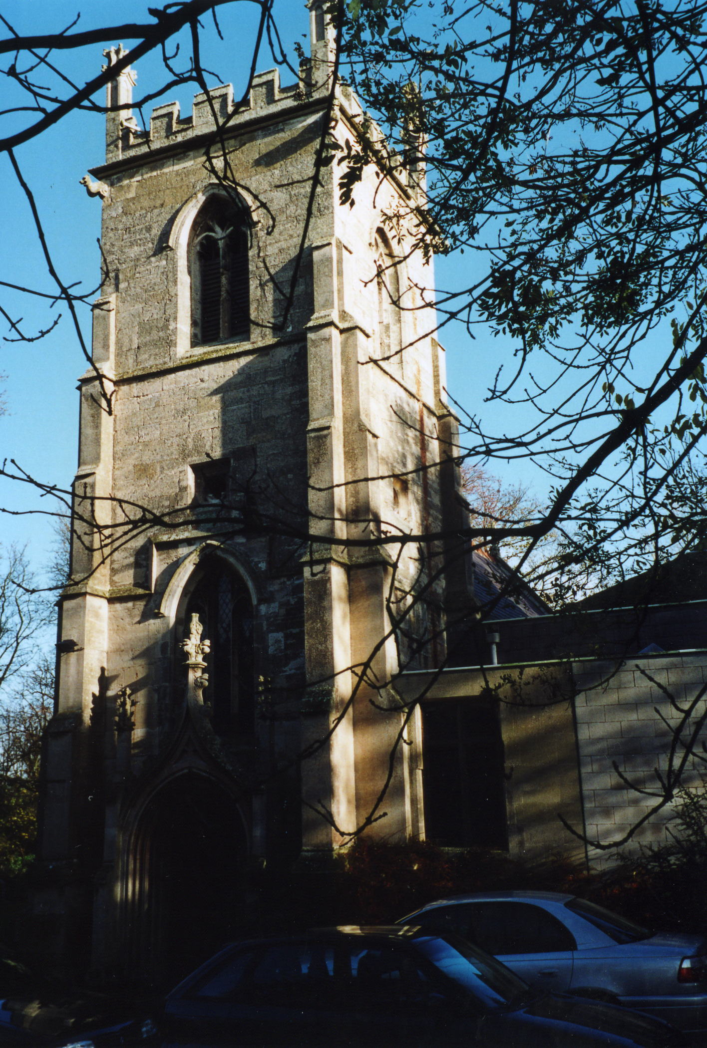
- The Anglican parish church is dedicated to Saint Peter and Saint Paul.
- The church is listed as "ancient", but I could find no absolute date of construction. The church has been dated to the 13th century.
- The church was partly rebuilt in 1840.
- The church is Grade II listed with British Heritage.
- The church seats between 80 and 102 people.
- The churchyard was expanded in 1925.
- There is a photograph of the Anglican parish church on the Wendy PARKINSON Church Photos web site.
- David WRIGHT has a photograph of the parish church on Geo-graph, taken in 2005.
- Here is a photo of Saints Peter and Paul's Church, taken by Ron COLE (who retains the copyright):
- The Anglican parish register dates from 1571.
- The Lincolnshire FHS has published several marriage indexes and a 1641/2 Protestation Return for the Haverstoe Deanery to make your search easier.
- The Primitive Methodists built a chapel here in 1899.
- David WRIGHT has a photograph of the Methodist church on Geo-graph, taken in October, 2005.
- Ian S. also has a photograph of the Healing Methodist Church on Station Road on Geo-graph, taken in September, 2017.
- For information and assistance in researching these churches, see our non-conformist religions page.
- Check our Church Records page for county-wide resources.
- The parish was in the Grimsby sub-district of the Caistor Registration District.
- In 1890, the parish was allocated to the Grimsby sub-district of the new Grimsby Registration District
. - Check our Civil Registration page for sources and background on Civil Registration which began in July, 1837.
Healing is both a village and a parish sitting 4 miles west of Grimsby. The parish covers about 2,500 acres, but was much smaller in the 19th century, covering only 1,335 acres.
If you are planning a visit:
- Steve FAREHAM has a photograph of the Village Sign on Geo-graph, taken in April, 2013.
- See our touring page for visitor services.
- J. THOMAS has a photograph of the Village Hall on Geo-graph, taken in March, 2013. Stop in and ask for a schedule of forth-coming events.
- Ask for a calculation of the distance from Healing to another place.
- The parish population grew rapidly after World War I presumably due to the growth of the nearby town of Grimsby.
- David WRIGHT has a photograph of Healing station on Geo-graph, taken in October, 2005. The station opened in 1848. The chedule for train service appears in the "Healing News" (See Periodicals).
- In the 1920s water mains were laid to provide fresh water to many of the homes in the parish.
- The present Healing Manor on Stallingborough road dates back to the early 1700s.
- Healing Manor was the residence of John MAUNSELL-RICHARDSON in 1900.
- In 1930, Captain Gerald Berkeley PORTMAN resided in Healing Manor.
- See the Healing Manor website for current information.
- See our Maps page for additional resources.
You can see maps centred on OS grid reference TA214101 (Lat/Lon: 53.573462, -0.16809), Healing which are provided by:
- OpenStreetMap
- Google Maps
- StreetMap (Current Ordnance Survey maps)
- Bing (was Multimap)
- Old Maps Online
- National Library of Scotland (Old Ordnance Survey maps)
- Vision of Britain (Click "Historical units & statistics" for administrative areas.)
- English Jurisdictions in 1851 (Unfortunately the LDS have removed the facility to enable us to specify a starting location, you will need to search yourself on their map.)
- Magic (Geographic information) (Click + on map if it doesn't show)
- GeoHack (Links to on-line maps and location specific services.)
- All places within the same township/parish shown on an Openstreetmap map.
- Nearby townships/parishes shown on an Openstreetmap map.
- Nearby places shown on an Openstreetmap map.
- The War Memorial is a grey Cornish granite obelisk which was erected in June, 1919, on the main Grimsby road. It commemorates 11 men who lost their lives in World War I.
- On the east end of the village, we Veterans can find the Royal British Legion club, here photographed by John Firth and placed on Geo-graph in June, 2012. The RBL is very active in the parish.
There is one Commonwealth War Grave in the churchyard from World War II:
- John BATES, corporal, RAF Vol. Rsrv., died 11 March 1945.
The names on the War Memorial (above) include:
- Carrot, Fred (could be CARROD, Fred)
- Chapman, Arthur
- Crockett, Wm Thos
- Epton, John
- FOWLER, Bateman, Royal Field Artillery
- LAMMIN, Albert Ernest, 1st/6th Northumberland Fusiliers
- Nightingale, Ernest
- Pinney, Chas E.
- PINNEY, Joseph, 6th Lincolnshire Regt.
- Rudkin, Harry
- WALLER, Charles, Middlesex Regt.
NOTE: Sirnames in ALL CAPS, above, have been found on the Commonwealth War Graves database.
- The name derives from the Old English Haegel+ingas, meaning "settlement of the family or followers of a man named Haegel". It appears as Hegelinga in the 1086 Domesday Book.
[Anthony D. MILLS, "A Dictionary of English Place-Names," Oxford University Press, 1991].
The Parish Council each month produces the Healing Village News. The Newsletter is distributed to every home and business within Healing and is also available to view at Healing Parish Newsletter.
- This place was an ancient parish in Lincolnshire and became a modern Civil Parish when those were established.
- The parish was in the ancient Bradley Haverstoe Wapentake in the Central Lindsey district and in the parts of Lindsey.
- Kelly's 1900 and 1913 Directories of Lincolnshire report, perhaps erroneously, that the parish is in the North Lindsey division of the county.
- In April, 1968, this Civil Parish was enlarged by 593 acres at the abolition of Great Coates Civil Parish.
- The Healing Parish Council meets at the Village Hall. They will NOT do family history lookups for you. The council does publish a monthly "Village News" which is distributed to residents of Healing.
- District governance is provided by the North-East Lincolnshire Council.
- Bastardy cases would be heard in the Grimsby petty session hearings.
- The Common Lands were enclosed here in 1839.
- As a result of the 1834 Poor Law Amendment Act, this parish became part of the Caistor Poor Law Union.
- In an 1890 reorganisation, this parish was transferred to the new Grimsby Poor Law Union.
- The children of the parish attended school in Stallingborough and Great Coates.
- A Public Elementary School was built here in 1910 for 102 children.
- See our Schools page for more information on researching school records.