
Hide
Heydour
hide
Hide
hide
Hide
hide
Hide
Hide
Hide
- The Library at Grantham will prove useful in your research.
- The Foster Library at the Lincolnshire Archives has a Bibliography of Heydour holdings.
- The parish was in the Grantham sub-district of the Grantham Registration District.
- Check our Census Resource page for county-wide resources.
- The table below gives census piece numbers, where known:
| Census Year | Piece Numbers |
|---|---|
| 1841 | H.O. 107 / 619 |
| 1851 | H.O. 107 / 2100 |
| 1861 | R.G. 9 / 2343 |
| 1871 | R.G. 10 / 3350 & 3363 |
| 1891 | R.G. 12 / 2586 |
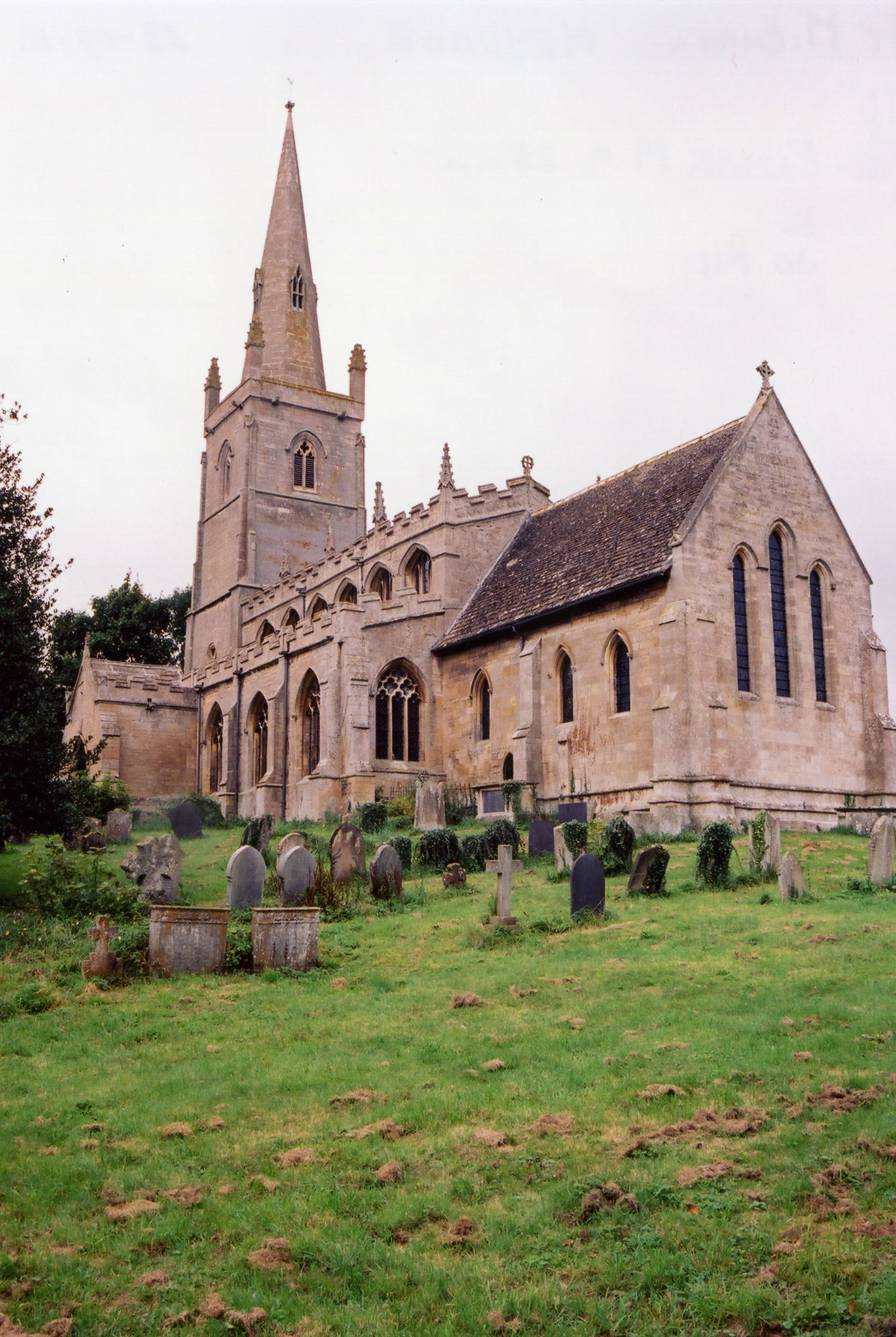
- The present Anglican parish church is dedicated to Saint Michael and All Angels and contains monuments to the NEWTON family.
- It was built in Norman times in the 12th century.
- The church seats 200.
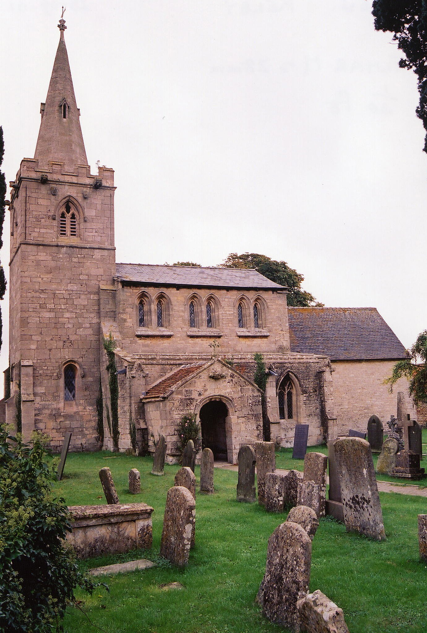
- Kelby (also: Chileby or Chillebi) was a chapelry of Heydour. The Anglican church in Kelby was dedicated to St. Andrew and was built in the Norman era. The tower and spire were rebuilt in 1850. The registers are included with those of Heydour.
- Photographs of the Anglican Church at Heydour and the one at Kelby are at the Wendy PARKINSON English Church Photographs site.
- Terry BUTCHER has a photograph of St. Michael's Church on Geo-graph, taken in March, 2006.
- Here is a photo of St. Michael's Church, taken by Ron COLE (who retains the copyright):
- Here is a photo of Kelby's St. Andrew's Church, taken by Ron COLE (who retains the copyright):
- Parish registers date from 1559 and include Kelby and Culverthorpe.
- The Lincolnshire FHS has a Loan Library service which has the parish registers on microfiche for Baptisms from 1559 to 1812 and Marriages from 1559 to 1812.
- Heydour is covered in the National Burial Index (NBI) for 1813 - 1900.
- Parish registers are on file at the Society of Genealogists, covering 1559 to 1837.
- The LFHS has published several indexes for the Loveden Deanery to make your search easier.
- The Primitive Methodists had a chapel here, erected in 1859 and rebuilt in 1899. For information and assistance in researching these chapels, see our non-conformist religions page.
- Check our Church Records page for county-wide resources.
- The parish was in the Grantham sub-district of the Grantham Registration District.
- Check our Civil Registration page for sources and background on Civil Registration which began in July, 1837.
This village and parish lies just over six miles east northeast of Grantham and five miles southwest of Sleaford. Welby parish is just to the west, with Aunsby parish to the east and Braceby to the south. The parish covers about 2,800 acres and includes the hamlets of Aisby (Azeby), Oseby (Ozeby or Oasby), Culverthorpe and Kelby.
The village of Heydour is just west of the A15 trunk road at Swarby. If you are planning a visit:
- Take the A15 south from Sleaford and turn west at Swarby or take the A153 east out of Sleaford and turn south at Wilsford.
- Visit our touring page for more sources.
- Ask for a calculation of the distance from Heydour to another place.
- Traces of a Roman villa were discovered near Aisby.
- Ancaster stone, used in the construction of many Lincolnshire buildings, was quarried here. In 1871, the local quarries were leased to Mr. William THOMPSON of Grantham.
- David HITCHBORNE has a photograph of Meliora's Memorial plaque on Geo-graph, taken in June, 2004.
- A Millenium Green was established on the Upper Green near Aisby in the year 2000.
- At last report (2012), the residents of Heydour were looking forward to a new Village Hall funded by a lottery win. The original Village Hall was a First World War Officers' Mess Hut obtained from the Belton Park Machine Gun Corps and extensively modified.
- Robert HARVEY has a photograph of Oasby's Memorial Bench (to George V) on Geo-graph, taken in February, 2019.
- Timothy HEATON has a photograph of The Houblon Arms, Oasby on Geo-graph, taken in March, 2021. The Inn is Listed Grade II. The building dates from around 1650.
- In 1841 and 1871, the principal landowner was John Archer HOUBLON.
- In 1913, the principal landowner was Col. George B. ARCHER-HOUBLON.
- In a field west of the church was the location of a large mansion (or castle) built in the reign of King Stephen by one of the BUSSEY family, who were seated here until about 1609. Only faint traces remain.
- Culverthorpe Hall, a building in the Italian style, was the seat of the NEWTON family.
- See our Maps page for resources.
You can see maps centred on OS grid reference TF009396 (Lat/Lon: 52.944313, -0.499882), Heydour which are provided by:
- OpenStreetMap
- Google Maps
- StreetMap (Current Ordnance Survey maps)
- Bing (was Multimap)
- Old Maps Online
- National Library of Scotland (Old Ordnance Survey maps)
- Vision of Britain (Click "Historical units & statistics" for administrative areas.)
- English Jurisdictions in 1851 (Unfortunately the LDS have removed the facility to enable us to specify a starting location, you will need to search yourself on their map.)
- Magic (Geographic information) (Click + on map if it doesn't show)
- GeoHack (Links to on-line maps and location specific services.)
- All places within the same township/parish shown on an Openstreetmap map.
- Nearby townships/parishes shown on an Openstreetmap map.
- Nearby places shown on an Openstreetmap map.
- David HITCHBORNE has a photograph of the War Memorial plaque on Geo-graph, taken in June, 2004.
These are the names on the WWI Memorial Brass in the parish church:
- sgt. Arthur SIMPSON, 2nd Lincs Regt.
- cpl. J. E. CABOURN
- gnr. Frank BRAMFORD, RFA, son of Thomas and Eliza.
- pte. R. W. KIRK, London Regt.
- pte. John H. MARTIN, son of Matthew and Mary.
- pte. E. W. PADLEY
- pte. J. W. PALMER
- pte. J. W. SMITH
- pte. Thomas STEVENS
- pte. John WATSON
- The name Heydour is of uncertain origin. The first part may come from the Old English heg or "hay". The village is listed in the 1086 Domesday Book as "Haidure" and "Heidure".
- The name Heydour is often listed in old records as Haydor. It also appears spelled as: Hather, Haydour and Heidure.
- Haydor is the "preferred" spelling of the name today, but both Heydour and Heydor are accepted.
- The name Oseby is often spelled in a varity of ways, such as Ozeby or Oasby. Locals prefer Oasby.
- White's 1871 Directory contains: BOOTH, CLOSE, COLLISHAW, DALE, DEEDES, DENNIS, EXTON, HEDWORTH, HOYES, LANE, LONGLAND, QUINNINGBOROUGH, ROLLINSON, SARDESON, SELBY, SINGLETON, SMITH, TAFT, WAKEFIELD, WATERS, WEIGHTMAN, WELBOURN and WILSON.
- Kelly's 1913 Directory contains: ALDERDRON, COX, CRAWFORD, DALE, KIRK, LANE, LONGLAND, NIXON, ROLLINSON, SARDESON, SELBY, THOMPSON, WAKEFIELD, WARD and WEIGHTMAN.
- This place was an ancient parish in Lincoln county and became a modern Civil Parish when those were established.
- The parish was in the ancient Winnibriggs and Threo Wapentake in the South Kesteven district in the parts of Kesteven.
- Culverthorpe is in the Aswardhurn Wapentake. It became a separate Civil Parish in 1866.
- Kelby was a seperate parish in olden times. It became a separate Civil Parish in 1866.
- You may contact the local Parish Council regarding civic or political issues, but they are NOT funded or staffed to assist you with family hisotry searches.
- For today's district governance, contact the South Kesteven District Council.
- Culverthorpe and Kelby fall under a different district governance. Contact the North Kesteven District Council.
- Bastardy cases would be heard in the Sleaford petty session hearings every Monday.
- Care of the poor dates back to at least 1756 when John HILTON left the interest on £20 for their care. That charity lapsed in the late 19th century.
- In 1803 when the fields were enclosed, 500 acres were set aside to raise funds for the poor.
- As a result of the 1834 Poor Law Amendment Act reforms, the parish became part of the Grantham Poor Law Union.
- Heydour had a school long before many other parishes. It was rebuilt in 1835, but no records retained from that earlier time.
- The school was enlarged to seat 150 children and converted to a Public Elementary School in 1885.
- For more on researching school records, see our Schools Research page.