
Hide
Hibaldstow
hide
Hide
hide
Hide
hide
Hide
Hide
Hibaldstow.-- par. and vil. (ry. sta. Scawby and Hibaldstow), N. Lincolnshire, 3 miles SW. of Brigg, 4390 ac., pop. 800; P.O.
John BARTHOLOMEW, "Gazetteer of the British Isles (1887)"
Hide
The Brigg Library is an excellent resource with a Local History section.
David WRIGHT has a photograph of the Churchyard of St. Hibald's on Geo-graph, taken in June, 2006.
- The parish was in the Brigg sub-district of the Glanford Brigg Registration District.
- Check our Census Resource page for county-wide resources.
- The table below gives census piece numbers, where known:
| Census Year | Piece No. |
|---|---|
| 1841 | H.O. 107 / 637 |
| 1861 | R.G. 9 / 2398 |
| 1871 | R.G. 10 / 3428 |
| 1891 | R.G. 12 / 2625 |
| 1901 | R.G. 13 / 3101 |
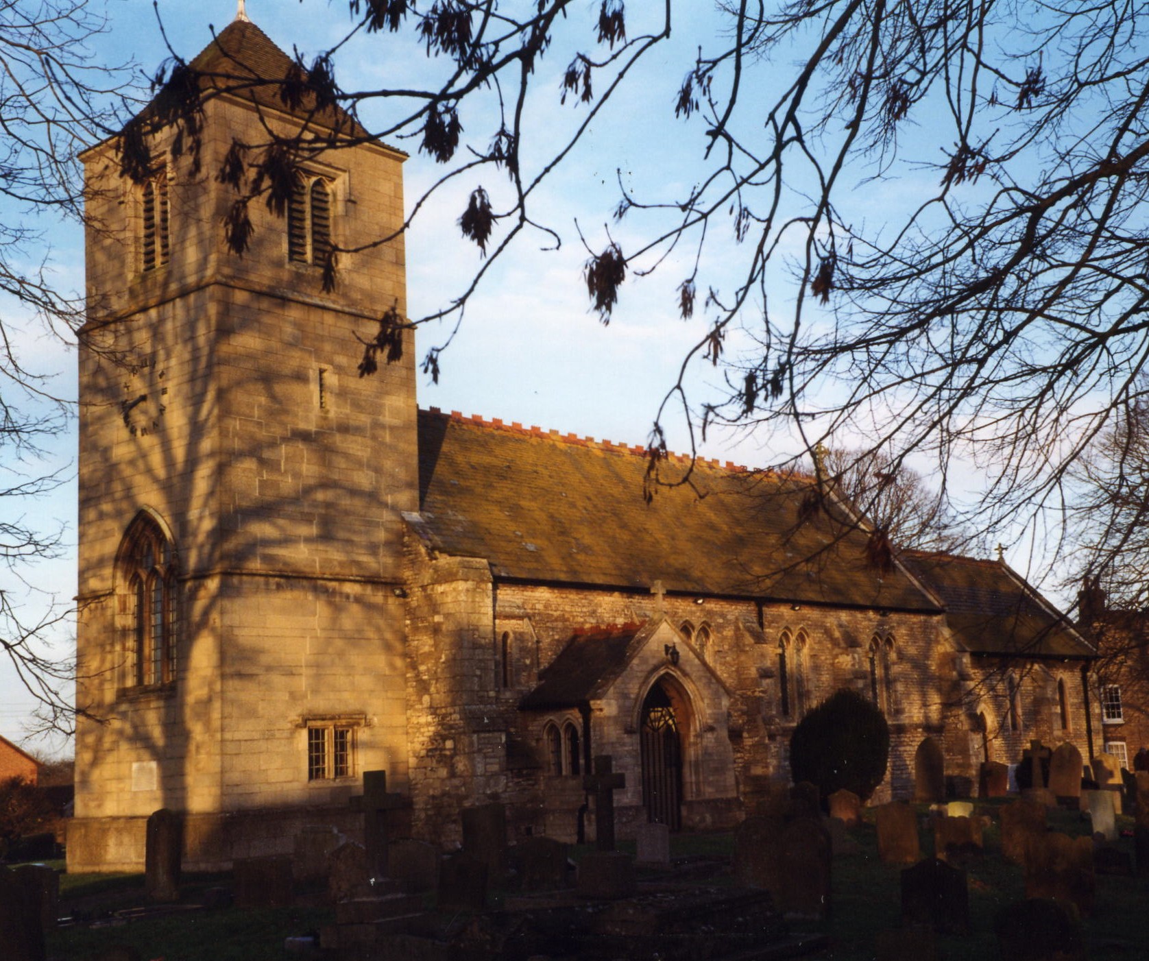
- The Anglican church is dedicated to Saint Hibbald from the 7th century who is said to be buried here.
- Sources differ on the spelling of the saint's name. Some list it as Hybbald, some as Hybald, and some as Hilbald. Because there was no standard for spelling in those ancient times, you may take your pick.
- The date of origin is unknown and likely Norman, but the original tower collapsed in July, 1875, and its arch has since been rebuilt.
- The church seats 200.
- There is a photograph of St. Hibbald's Church on the Wendy PARKINSON Church Photos web site, taken by Paul FENWICK.
- There is another fine photograph of St. Hibald's Church taken by Richard CROFT in September, 2005.
- Here is a photo of St. Hibbald's Church, taken by Ron COLE (who retains the copyright):
- The parish register dates from 1631, but Bishop's transcripts go back to 1599.
- We have some interesting extracts from the parish register.
- The LFHS has published several marriage indexes for the Yarborough Deanery to make your search easier. The parish has also been in the Corringham deanery.
- The The Lincolnshire Family History Society has indexed burials in the Kirton Lindsey area for 1813-1900, including Hibaldstow.
- The Lincolnshire Family History Society also has indexed marriages for post-1837 for Hibaldstow.
- The Wesleyan Methodists built a chapel here in 1814. In 1841, the Primitive Methodists built their chapel. The United (or Free) Methodists built a chapel to seat 250 people in 1865. This is still an active Methodist chapel in the parish. For information and assistance in researching these chapels, see our non-conformist religions page.
- The Lincolnshire Chronicle for 7 Jan 1853 gives an account of the sudden death at New Holland on Christmas Day of Uriah BUTTERS, Wesleyan Methodist Minister of Hibaldstow.
- Check our Church Records page for county-wide resources.
- The parish was in the Brigg sub-district of the Glanford Brigg Registration District.
- Check our Civil Registration page for sources and background on Civil Registration which began in July, 1837.
Hibaldstow is both a village and a parish in the north of Lincolnshire, just west of the River Ancholme. A small stream runs from the village to the River Ancholme. The parish lies 163 miles north of London, 19 miles north of the City of Lincoln and 3.5 miles south-west of Brigg. Scawby parish lies to the north, Redbourne parish to the south and Manton parish to the west. The parish covers just over 4,400 acres of low cars (see our Geographic Names page) or marshes.
Parish boundaries have changed over the last two centuries. Go here to find the West Lindsey ward (modern parish) boundaries.
The village of Hibaldstow is about a mile east of the old Roman road, Ermine Street, now the A15 trunk road. If you are planning a visit:
- Take the A15 trunk road north out of Lincoln. Alternatively, take the B1207 south off of the M180 Motorway between Brigg and Scunthorpe.
- Stop by the Village Hall on Station Street to see what events are planned during your visit.
- Visit our touring page for more sources.
- Ask for a calculation of the distance from Hibaldstow to another place.
- Wikipedia tells us that Hilbaldstow's earliest mention was as a Roman legionary 'roadside fort' on Ermine Street.
- Hilbaldstow was founded in the seventh century, the earliest mention being in a grant of 664 when it is spelt Hibaldstow (also now the modern spelling).
- About a mile west of the village, just off Ermine Street, is evidence of an early settlement, perhaps Roman.
- The Roman's left evidence of iron smelting at Hibaldstow. See: Martin J. DEARNE & Keith BRANIGAN, "The use of coal in Roman Britain," Antiquaries Journal, vol 75, 1995, pp71-105.
- Two miles south-west of the village church are traces of the village once known as Gainsthorpe. The adjacent farm still bears that name. It is believed to been a Roman fort originally because the west wall of 400 yards is still distinct. Roman coins and pavement stones have been found near the spot.
- In 1866, during the rebuilding of the church chancel, a Saxon-era sarcophagus was found, containing the skeleton of a powerfully built man. It is presumed to be that of Saint Hibald.
- The Blue Lias Lime and Cement works, ow
ned by H. PARRY & Sons, employed a large number of local men in the late 1800's and early 1900's.
- The North Lincolnshire Library holds a copy of "The Story of a Parish - A Short History of Hibaldstow", (compiled by Mary INSULL), 1958.
- J. THOMAS has a photograph of the Wheatsheaf pub on Geo-graph, taken in April, 2014. This pub is on the west side of the B1207 arerial road.
- In 1871, the principal land holders were M. D. DALISON, the Duke of St. Albans and Sir M. J. CHOLMELEY, member of Parliament.
- In 1913, the principal land holders were Maximilian H. D. DALISON and the Duke of St. Albans.
- The national grid reference is SE 9702.
- You'll want an Ordnance Survey Explorer map, which has 2.5 inches to the mile scale.
- See our "Maps" page for additional resources.
You can see maps centred on OS grid reference SE978026 (Lat/Lon: 53.510918, -0.52597), Hibaldstow which are provided by:
- OpenStreetMap
- Google Maps
- StreetMap (Current Ordnance Survey maps)
- Bing (was Multimap)
- Old Maps Online
- National Library of Scotland (Old Ordnance Survey maps)
- Vision of Britain (Click "Historical units & statistics" for administrative areas.)
- English Jurisdictions in 1851 (Unfortunately the LDS have removed the facility to enable us to specify a starting location, you will need to search yourself on their map.)
- Magic (Geographic information) (Click + on map if it doesn't show)
- GeoHack (Links to on-line maps and location specific services.)
- All places within the same township/parish shown on an Openstreetmap map.
- Nearby townships/parishes shown on an Openstreetmap map.
- Nearby places shown on an Openstreetmap map.
- The RAF opened an airfield here in May, 1941, using a field that used to be a rabbit warren.
- The Luftwaffe threat had largely evaporated by 1943, so the field was temporarily closed in January of that year. The field re-opened in May when a new squadron was assigned.
- There is a booklet detailing the history of the RAF Hibaldstow, pub. circa 1995, but availability appears to be limited.
- The airfield ceased flying operations in May, 1945, and the field was closed in August, 1947. The buildings were dismantled shortly after the closing. The land was sold off early in the 1960s.
- Pat HORTON reminds me that there are Remembrance Books in St. Hibbald's Church and you are invited to browse and leave your notes as well.
- The War memorial for Hibaldstow is to be found on the exterior wall of the War Memorial Club, West Street.
The origin of the parish name is Old English Hygebald+stow, for "holy place where St. Hygebald is buried". It appeared in the 1086 Domesday Book as Hiboldestou. Variations in the spelling abound, even within a single document. Some writers have suggested that the name was originally Hubba, a Danish commander or leader.
[A. D. Mills, "A Dictionary of English Place-Names," Oxford University Press, 1991]
The Venerable Bede in his 'Ecclesiastical History' describes St Hygbald as a most holy and continent man who was an abbot in Lindsey, Lincolnshire. One theory which links St Hygbald with Hibaldstow is that in the year 669 St Chad received the Diocese of Mercia and began to preach in Lindsey, setting up a mission station at or near Cadney. It is thought that Hygbald was a pupil of Chad and that he may well have imitated his teacher and set up his own mission station at Hibaldstow. St Hygbald's links with the village were further re-enforced when during the rebuilding of the parish church in 1866 a stone coffin was unearthed. It contained the bones of a tall and powerful man and it was said at the time that they might well have been the mortal remains of St Hygbald. More information can be found in: Eminson, T.B.F. "Place and River Names of the West Riding of Lindsey, Lincolnshire".
- The North Lincolnshire Library holds copies of the Star Newspaper Index with several articles on Hibaldstow.
- This place was an ancient parish in Lincoln county and became a modern Civil Parish when those were established.
- The parish was in the ancient Manley Wapentake in the Glanford Brigg division of the county, in the parts of Lindsey.
- In April, 1967, the parish was reduced by 4 acres granted to Cadney Civil Parish.
- For today's district governance, see the North Lincolnshire Council website.
- Bastardy cases would be heard in the Winterton petty session hearings.
- The Common Fields were enclosed here in 1796 and 1803.
- After the Poor Law Amendment Act of 1834, this parish became part of the Glanford Brigg Poor Law Union.
- In 1897, George WATSON left a charity of £20, the interest to be distributed each July 13th to poor widows over 50 years of age.
Year Inhabitants 1801 443 1811 528 1821 522 1831 632 1841 688 1851 801 1861 775 1871 764 1881 800 1891 818 1901 726 1911 834 1921 898 1931 1,002 1951 1,034 2011 2,433
- A Public Elementary School was built here in 1874 and enlarged in 1895. It held up to 160 children.
- The North Lincolnshire Library holds a copy of the Star Newspaper Index, Schools closed due to Whooping Cough, LS 23.6.1917 2f.
- Hibaldstow also has a pre-school now in the village.
- For more on researching school records, see our Schools Research page.