
Hide
Horsington
hide
Hide
hide
Hide
hide
Hide
Hide
Hide
- Some time before 1770, the parishioners purchased a burial ground, about an acre in size, which lies a little over a mile from the Anglican church.
- The parish was in the Horncastle sub-district of the Horncastle Registration District.
- The North Lincolnshire Library holds copies of the census returns for 1841 and 1881.
- Check our Census Resource page for county-wide resources.
- The table below gives census piece numbers, where known:
| Census Year | Piece No. |
|---|---|
| 1841 | H.O. 107 / 637 |
| 1851 | H.O. 107 / 2107 |
| 1861 | R.G. 9 / 2368 |
| 1871 | R.G. 10 / 3382 |
| 1891 | R.G. 12 / 2598 |
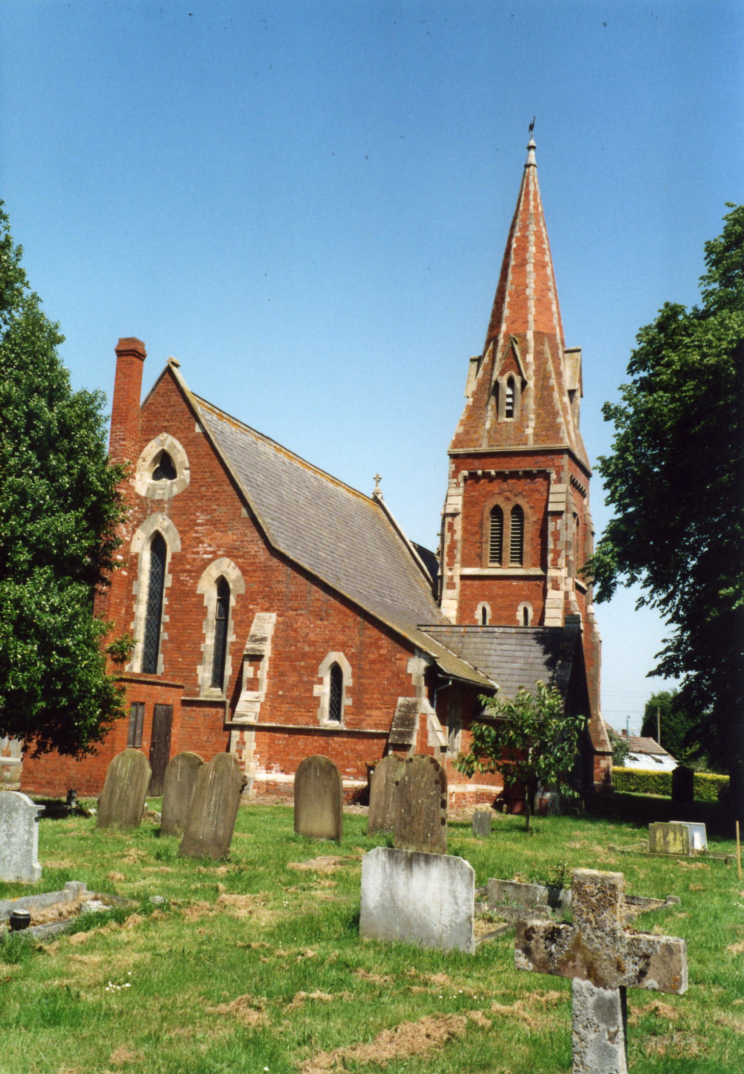
- The Anglican parish church was dedicated to All Saints and was originally a thatched structure.
- The original church fell into ruins in the mid-1800s. A temporary structure was used for a few years for services.
- The church was rebuilt of red brick with stone dressings in 1860 and dedicated to All Saints.
- A photograph of the Anglican church is at the Wendy PARKINSON English Church Photographs site.
- Gary BROTHWELL has a photograph of All Saints Church on Geo-graph, taken in August, 2010.
- Here is a photo of All Saints Church, taken by Ron COLE (who retains the copyright):
- Parish registers exist from October 1558. Bishop's Transcripts exist from 1561.
- The LFHS has published several marriage indexes for the Horncastle Deanery to make your search easier.
- The Lincolnshire Archives have the general register deposited for 1558 through 1673 as well as some later dates.
- The Wesleyan Methodists builkt a chapel here in 1837. The Primitive Methodists built a chapel here in 1819. The parish is now part of the Horncastle and Bardney Circuit. The Lincolnshire FHS has a fiche listing some "Lincolnshire Methodist Membership Lists - Horncastle and Grimsby areas, 1769 to 1823." Also, check our Non-Conformist Church Records page for additional resources.
- Check our Church Records page for county-wide resources.
- The parish was in the Horncastle sub-district of the Horncastle Registration District.
- Check our Civil Registration page for sources and background on Civil Registration which began in July, 1837.
Horsington is both a village and a parish. The parish lies about five miles west of Horncastle. The parish itself is bounded on the north by Wispington parish, to the west by Bucknall, on the south by Stixwould and on the east by Woodhall. One arm of the parish slips under Bucknall and ends at the River Witham on the south-west. The parish is in the western edge of The Wolds and covers about 1,900 acres.
The parish includes the ancient village of Horsington and a number of scattered farms in the area. The village is about 3 and 1/2 miles east of the River Witham. If you are planning a visit:
- By automobile, it is probably easiest to take the B1190 west out of Horncastle.
- Watch for The SIGN!. Here it is photographed by Mike FOWLES in April, 2006.
- Stop by the Village Hall and ask about their scheduled events.
- P C Coaches provides bus service trom Cheery WIllingham to Horncastle, passing thru the parish. See the transport page for more information.
- Visit our touring page for more sources.
- Ask for a calculation of the distance from Horsington to another place.
- From time immemorial, five acres of land have belonged to the parish for the repairs of the Anglican church.
- Stop by the Elder Tree Inn and ask about their history. The photo is by Richard CROFT.
- These are the names associated with the Inn in various directories:
| Year | Person |
|---|---|
| 1900 | -- not listed -- |
| 1913 | -- not listed -- |
| 1930 | William DONSON, beer retailer |
The Old Baronet Inn, which dated from the 1600s, has closed and has been sold as a private residence.
- In 1871, the greater part of the parish was held by Magdalen College, Oxford. Other landowners included Christopher and Jabez TURNOR, the Reverend Francis H. DEANE and Mrs. CLAYTON.
- In 1913, the principal landowners included Magdalen College, WIlliam LANE-CLAYPON of Hertfordshire and Mr. Elton SCOTT of Horsington.
- See our Maps page for additional resources.
You can see maps centred on OS grid reference TF192687 (Lat/Lon: 53.20202, -0.216909), Horsington which are provided by:
- OpenStreetMap
- Google Maps
- StreetMap (Current Ordnance Survey maps)
- Bing (was Multimap)
- Old Maps Online
- National Library of Scotland (Old Ordnance Survey maps)
- Vision of Britain (Click "Historical units & statistics" for administrative areas.)
- English Jurisdictions in 1851 (Unfortunately the LDS have removed the facility to enable us to specify a starting location, you will need to search yourself on their map.)
- Magic (Geographic information) (Click + on map if it doesn't show)
- GeoHack (Links to on-line maps and location specific services.)
- All places within the same township/parish shown on an Openstreetmap map.
- Nearby townships/parishes shown on an Openstreetmap map.
- Nearby places shown on an Openstreetmap map.
- There is a single World War II grave in the churchyard.
In the church is a memorial brass to Col. Bonar Millet DEANE who fell at the battle of Laings Nek in South Africa on 28 Jan. 1881.
Another memorial brass is in memory of Lieut. Evan Cowper SMITH who died of fever in Afganistan, 16 July 1880 aged 19.
And a third memorial brass is in memory of Capt. Arthur Monroe Cowper SMITH who died of injuries while shooting big game on the Pungwe River on 28 Sept. 1898.
In the churchyard is a Commonwealth War Grave from World War I for:
- H. LONGTHORN, priv., 4th Btn. Training Reserve, age 18, died 15 Mar. 1917. Son of George and H. S. LONGTHORN.
- The name derives from the Old English Horsa+ing+tun, meaning "estate or farm belonging to Horsa". It appears in the 1086 Domesday Book as Horsintone.
A. D. Mills, "A Dictionary of English Place-Names," Oxford University Press, 1991.
- White's 1872 Directory lists the following surnames in the parish: ABLEWHITE, BELTON, BROWN, CHAFOX, CHAPMAN, CLIFTON, COX, CROFT, CUMMINS, DEANE, DUCKERING, ELMITT, ELVIN, FREEMAN, GRAYSON, GREEN, JACKSON, KEELEY, MAJOR, PRIESTLEY, ROBERTS, SCOTT, SHARP, SKINN, STOTHARD, TIMSON, WALTER and WHALER.
- Kelley's 1913 Directory lists the following surnames in the parish: ABLEWHITE, BATES, BLADES, BROWN, CHAPMAN, CLIFTON, COOK, CROFT, CUMMINS, FOWLER, GOODYEAR, GREEN, HILL, MOORE, NEWTON, PINCHBECK, POUCHER, ROOK, SCOTT, SIDEBOTTOM, SIMPSON, TINKER, WALTER and WRIGHT.
- This place was an ancient parish in Lincoln county and became a modern Civil Parish when those were established.
- The parish was in the southwest division of the ancient Gartree Soke in the East Lindsey district in the parts of Lindsey.
- In April, 1936, this parish gained 623 acres from Edlington Civil Parish.
- For today's district governance, see the East Lindsey District Council.
- Bastardy cases would be heard in the Horncastle petty session hearings every Saturday.
- The Lincolnshire Archives have settlement examionations and removal orders for 1703 through 1850 as well as some bastardy bonds for 1772 through 1834.
- The Common Fields were enclosed here in 1760 and about 290 acres were allocated to the church in lieu of tithes.
- As a result of the 1834 Poor Law Amendment Act, the parish became part of the Horncastle Poor Law Union on 16th January 1837.
Year Inhabitants 1801 183 1811 216 1821 322 1831 323 1841 345 1851 399 1871 397 1881 360 1891 266 1901 220 1911 224
- A National School was built here in 1861 and was attended by over 60 students in 1871. By 1913 that count had dropped to 30.
- For more on researching school records, see our Schools Research page.