
Hide
Keddington
hide
Hide
hide
Hide
hide
Hide
Hide
Hide
The nearby Louth Library will prove useful in your research.
Richard CROFT has a photograph of St. Margaret's churchyard on Geo-graph, taken in March, 2009.
- The parish was in the Louth sub-district of the Louth Registration District.
- The North Lincolnshire Library has census returns for this parish for 1841 and 1881.
- Check our Census Resource page for county-wide resources.
- The table below gives census piece numbers, where known:
| Census Year | Piece No. |
|---|---|
| 1841 | H.O. 107 / 638 |
| 1851 | H.O. 107 / 2111 |
| 1861 | R.G. 9 / 2383 |
| 1871 | R.G. 10 / 3404 |
| 1891 | R.G. 12 / 2608 |
| 1901 | R.G. 13 / 3084 |
- A Cistercian house, Louth Abbey was founded in 1139, and was dissolved at suppression in 1536.
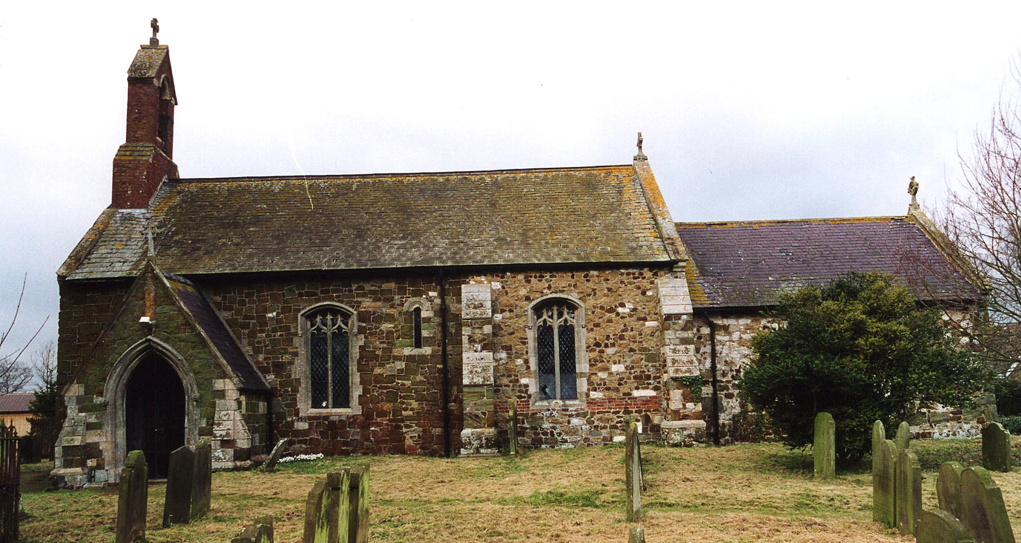
- The small Anglican parish church is dedicated to Saint Margaret.
- Construction started in the late 12th century.
- The church was thoroughly restored in 1871 - 72. Folks from Louth Park attended this church.
- The church seated about 120.
- The church was declared redundant by the Diocese of Lincoln in December, 1999.
- The church is a Grade II listed building with British Heritage.
- At last report (2013), the building was being renovated, but is in private ownership.
- Richard CROFT has a photograph of St. Margaret's Church on Geo-graph, taken in November, 2008.
- A photograph of St. Margaret's exists at the Wendy PARKINSON English Church Photographs site.
- Here is a photo of St. Margaret's Church, taken by Ron COLE (who retains the copyright):
- Parish registers exist from 1563. Bishop's transcripts go back to 1561.
- We have the beginning of a Parish Register Extract in a text file. Your additions and corrections are welcome.
- The LFHS has published several indexes for the Louthesk Deanery to make your search easier.
- The National Burial Index (NBI) has 602 entries for St. Margaret's Church covering the years 1813 - 1900.
- Check our Church Records page for county-wide resources.
- The parish was in the Louth sub-district of the Louth Registration District.
- Check our Civil Registration page for sources and background on Civil Registration which began in July, 1837.
This village and parish lie one and a half miles north-east of Louth and about 3 miles west of Cockerington. It is bordered on the north by Brackenbury and Alvingham parishes, with Stewton parish just to the south. The parish is on the eastern side of the Wolds, and includes about 1,040 acres.
The small village itself lies just north of the Louth Navigation Canal (the River Lud), and is sandwiched between the two roads out of Louth to Alvington and Cockerington. If you are planning a visit:
- Take either the Alvington or Cockerington road east out of Louth.
- Visit our touring page for more sources.
- Ask for a calculation of the distance from Keddington to another place.
Richard CROFT has a photograph of a memorial to the poet Andreas Kalvos on Geo-graph, taken in June, 2015.
- In 1872, Sir Glynne Earle WELBY-GREGORY, baronet, was the principal landowner and lord of the manor.
- In 1900, Sir Charles Glynne Earle WELBY, baronet, was the principal landowner and lord of the manor.
- See our Maps page for additional resources.
You can see maps centred on OS grid reference TF346887 (Lat/Lon: 53.37785, 0.021372), Keddington which are provided by:
- OpenStreetMap
- Google Maps
- StreetMap (Current Ordnance Survey maps)
- Bing (was Multimap)
- Old Maps Online
- National Library of Scotland (Old Ordnance Survey maps)
- Vision of Britain (Click "Historical units & statistics" for administrative areas.)
- English Jurisdictions in 1851 (Unfortunately the LDS have removed the facility to enable us to specify a starting location, you will need to search yourself on their map.)
- Magic (Geographic information) (Click + on map if it doesn't show)
- GeoHack (Links to on-line maps and location specific services.)
- All places within the same township/parish shown on an Openstreetmap map.
- Nearby townships/parishes shown on an Openstreetmap map.
- Nearby places shown on an Openstreetmap map.
- This memorial stands in Keddington churchyard: Christopher STANILAND Flt Lieut. R A F chief test pilot to the Fairy Aviation Company Killed in a Flying Accident June 26th 1942.
- Keddington is from the Old English Cydda+ing+tun, meaning "farmstead of a man called Cydda", and is rendered as Cadington in the 1086 Domesday Book. In the 12th century, the name appears as Kedingtuna.
[A. D. Mills, "A Dictionary of English Place-Names," Oxford University Press, 1991]
- These surnames were taken from the 1872 White's Directory: CARRATT, CLARK, FORMAN, MASHFORD, MASON, SMITH and TICKLEPENNY.
- These surnames were taken from the 1900 Kelly's Directory: CARTWRIGHT, EAST, ELVING, HOWES, LARDER, MASHFORD, MONCASTER, POTTS, ROBINSON, WASS and WEBSTER.
- These surnames were taken from the 1913 Kelly's Directory: CARTWRIGHT, CODD, CORDEN, ELVING, FENWICK, FOREMAN, GIBSON, KENT, LARDER, MASHFORD, PRIDGEON and THOMPSON.
- This place was an ancient parish in Lincoln county and became a modern Civil Parish when those were established.
- The parish was in the ancient Wapentake of Louth Eske in the East Lindsey district in the parts of Lindsey.
- For today's governance, see the East Lindsey District Council.
- In April, 1936, this parish was reduced by three acres to enlarge Louth Civil Parish.
- In April, 1936, Louth Park Civil Parish was abolished and 827 acres were amalgamated with this Civil Parish.
- Bastardy cases would be heard in the Louth petty session hearings every other Wednesday.
- The parish had 6 acres and 2 rods of Poor Land given by an unknown donor.
- After the 1834 Poor Law Amendment Act reforms, the parish became part of the Louth Poorlaw Union.
- The children of the parish attended schools at Louth.
- For more on researching school records, see our Schools Research page.