
Hide
Keelby
hide
Hide
hide
Hide
hide
Hide
Hide
Keelby, par. and vil., Lincolnshire, 7 miles NE. of Caistor, 1,861 ac., pop. 742; P.O.
From: John BARTHOLOMEW's "Gazetteer of the British Isles (1887)"
Hide
The Caistor Library is an excellent resource with a Local History section and a Family History section.
Alternatively, you can use the Grimsby Library as a resource, also.
- Brian CHESTER has provided a Monument Inscription lookup feature at his website for Keelby cemetery.
- The Keelby Cemetery required restoration after the June, 2007, floods. The local Rotary Club co-ordinated much of the work
- The parish was in the Caistor sub-district of the Caistor Registration District.
- Check our Census Resource page for county-wide resources.
- In the 1891 census, the parish is indexed as North Kelsey, Enum Dist, 15 and 16.
- The table below gives census piece numbers, where known:
| Census Year | Piece No. |
|---|---|
| 1841 | H.O. 107 / 638 |
| 1851 | H.O. 107 / 2100 |
| 1861 | R.G. 9 / 2393 |
| 1871 | R.G. 10 / 3422 |
| 1881 | R.G. 11 / 3280 |
| 1891 | R.G. 12 / 2622 |
| 1901 | R.G. 13 / 3098 |
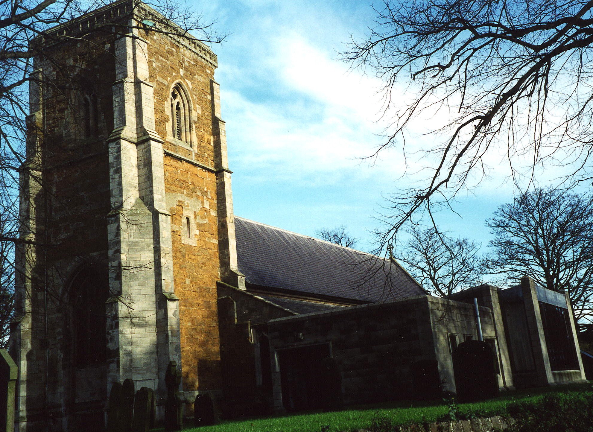
- The Anglican parish church is dedicated to Saint Bartholomew.
- The church is over 600 years old. Some portions date back to Norman times.
- The church chancel and tower were repaired in 1905.
- The church seats 244.
- The church is Grade I listed with English Heritage.
- A photograph of St. Bartholomew's Church is at the Wendy PARKINSON English Church Photographs site.
- Richard CROFT has a photograph of St. Bartholomew's Church on Geo-graph, taken in March, 2006.
- Here is a photo of St. Bartholomew's Church, taken by Ron COLE (who retains the copyright):
- The Anglican parish register dates from 1565.
- The Lincolnshire FHS has published several marriage indexes for the Haverstoe Deanery to make your search easier.
- There was a Primitive Methodist chapel built here in 1850. The Primitive Methodists closed the chapel for worship some time after 1930.
- David HEBB has a photograph of the old Methodist chapel on Geo-graph, taken in September, 2010.
- There was an Wesleyan Methodist chapel with a Sunday School built in the parish in 1867. Check our Non-Conformist Church Records page for additional resources.
- Check our Church Records page for county-wide resources.
- The parish was in the Caistor sub-district of the Caistor Registration District.
- Check our Civil Registration page for sources and background on Civil Registration which began in July, 1837.
This village and parish lies about 7 miles north-east of Caistor and 9 miles west of Grimsby. Riby parish lies to the south-east. The parish covers about 1,860 acres.
The Coble Beck runs through the parish. If you are planning a visit:
- By automobile, take the A18 arterial road west out of Laceby or east out of Great Limber. The road runs along the south-west border of the village.
- David WRIGHT has a photograph of the Vilage Hall on Geo-graph, taken in January, 2006.
- See our touring page for visitor services.
- Ask for a calculation of the distance from Keelby to another place.
- A Foresters' Hall was built here in 1847. The foundation stone was laid by Lord Worsley.
- A Church Institute was built here in 1898 of white brick. It holds about 200 persons.
- The village used to hold a pleasure fair every 10th of July.
- John FIRTH has a photograph of the Kings Head Pub. on Geo-graph, taken in June, 2012.
- These are the names associated with the King's Head Inn in various directories:
| Year | Proprietor |
|---|---|
| 1842 | Mary RIPPER, vict. |
| 1872 | George BLANCHARD, vict. |
| 1882 | Willaim TAYLOR, vict. |
| 1900 | Harry MARSHALL |
| 1913 | Ross N. OLIVER |
| 1930 | Arthur OLIVER |
- The village was struck by an F1/T2 tornado on 23 November 1981, as part of the record-breaking nationwide tornado outbreak on that day.
- See our Maps page for additional resources.
You can see maps centred on OS grid reference TA164102 (Lat/Lon: 53.575232, -0.244017), Keelby which are provided by:
- OpenStreetMap
- Google Maps
- StreetMap (Current Ordnance Survey maps)
- Bing (was Multimap)
- Old Maps Online
- National Library of Scotland (Old Ordnance Survey maps)
- Vision of Britain (Click "Historical units & statistics" for administrative areas.)
- English Jurisdictions in 1851 (Unfortunately the LDS have removed the facility to enable us to specify a starting location, you will need to search yourself on their map.)
- Magic (Geographic information) (Click + on map if it doesn't show)
- GeoHack (Links to on-line maps and location specific services.)
- All places within the same township/parish shown on an Openstreetmap map.
- Nearby townships/parishes shown on an Openstreetmap map.
- Nearby places shown on an Openstreetmap map.
- The RAF opened an airfield here late in World War I. It had a short existence and was abandoned in 1919. The field was called "Greenland Top" officially, but some units refered to the field as "Stallingborough," which may have been a pun based on the name and the flight characteristics of certain aircraft.
- In May, 1921, the parish erected a cross in the village in memory of the men of the parish who fell in World War I.
- In addition to the inscriptions of the fallen servicemen there is also a memorial to the “Lancaster Sisters”. Dorothy and Annie lived at the Manor and lost their lives during the sinking of the Lusitania 1915.
- In 1930 Lieut.-Col Joseph Hugh WARD, D.S.O. lived in the village. He was a physician and surgeon.
There are 21 names inscribed on the War Memorial plinth:
- Abey, F.
- Brown, A. J.
- Hill, T. E.
- Hilton, J. E. H.
- Jackson, A. F.
- Johnson, H. P.
- Lancaster, Annie
- Lancaster, Dorothy
- Newmarch, C.
- Overton, A.
- Parker, H.
- Plaskitt, C. H.
- Reed, A.
- Rodgers, T. H.
- Skinner, E.
- Somerscales, S. A.
- Stamp, J. W.
- Stiff, Graham
- Thompson, A.
- Walkley, S. O.
- Wright, W. J.
Dorthy LANCASTER was buried in Keelby on 28 May 1915 at age 26. She was the daughter of William LANCASTER and Eleanor Jane LANCASTER (nee FISHER). She was born in Keelby in 1888. Her sister Annie was born about 1884, also in Keelby, LIN. Annie was also laid to rest in Keelby on 28 May 1915.
There is a Roll of Honour mounted on the wall of Saint Bartholomew's Church with 159 names on it.
- In the 1086 Domesday Book, the name is given as "Chelebi", meaning "ridge valley". The name was given by the Danes.
- Locals pronounce the name as "KEEL-bee". Others may use "KEEL-bi".
- This place was an ancient parish in Lincolnshire and became a modern Civil Parish when those were established.
- The parish was in the East Division of the ancient Yarborough Wapentake in the West Lindsey district in the parts of Lindsey.
- At times, due to government re-organisation, the parish has been in the North Lindsey district.
- Today's district governance is provided by the West Lindsey District Council.
- Bastardy cases would be heard in the Caistor petty session hearings.
- Miss M. A. HILL left a charity (undated, but prior to 1909) which produced about £25 each year in 1930 to be donated to the poor.
- Mrs. Alice SOUTH left 10 acres of land for the poor in 1605. This bequest still provides for small gifts at Christmas for local retired villagers.
- As a result of the 1834 Poor Law Amendment Act, this parish became part of the Caistor Poor Law Union.
- A School Board was formed on 14 Feb, 1873.
- A Board School was built in 1879 to hold up to 150 children.
- See our Schools page for more information on researching school records.