
Hide
Lissington
hide
Hide
hide
Hide
hide
Hide
Hide
Hide
The Community Library at Caistor has a local history archive that will prove useful in your research.
- The parish was in the Market Rasen sub-district of the Caistor Registration District.
- Check our Census Resource page for county-wide resources.
- The table below gives census piece numbers, where known:
| Census Year | Piece No. |
|---|---|
| 1841 | H.O. 107 / 639 |
| 1861 | R.G. 9 / 2396 |
| 1871 | R.G. 10 / 3426 |
| 1891 | R.G. 12 / 2624 |
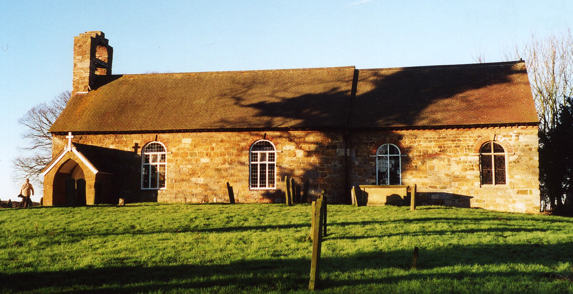
- The Anglican parish church is dedicated to Saint John the Baptist.
- The church was restored in 1895 and again in 1911-12.
- The church is a Grade II listed building with British Heritage.
- The church seats 100.
- Richard CROFT has a wintertime photograph of St. John's Church taken in January, 2013.
- Here is a photo of St. John's Church, taken by Ron COLE (who retains the copyright):
- The Anglican parish register dates from 1562.
- There are 301 burials listed in the National Burial Index (NBI) covering 1813-1900.
- The Lincolnshire FHS has published several marriage indexes and a burial index for the Westwold Deanery to make your search easier.
- The Wesleyan Methodists and the United Methodists each had a small chapel here. For information and assistance in researching these chapels, see our non-conformist religions page.
- Jonathan THACKER has a photograph of one of the Methodist Chapels taken in December, 2012.
- Check our Church Records page for county-wide resources.
- The parish was in the Market Rasen sub-district of the Caistor Registration District.
- Check our Civil Registration page for sources and background on Civil Registration which began in July, 1837.
This village and parish are 4 miles south of Market Rasen and 4 miles north of Wragby. The parish covers just over 1,500 acres.
If you are planning a visit:
- J. THOMAS has a photograph of the Village Sign on Geo-graph, taken in September, 2014. Perhaps they could use your artistic talent and marketing savy to creat a more enticing sign.
- Visit our touring page for visitor services.
- Ask for a calculation of the distance from Lissington to another place.
- There is a photograph of the White Hart Public House taken by Glyn DRURY in 2010.
- And another White Hart P. H. taken by John FIRTH in 2012.
- The White Hart Public House provided a centre for community gossip and communication. Individuals' names associated with the Inn from directories are:
| Year | Person |
|---|---|
| 1842 | Humphrey BARKER, vict. |
| 1861 | John Humphrey BARKER |
| 1872 | John Humphrey BARKER, farmer |
| 1882 | Mrs. Charlotte BARKER |
| 1900 | George FOX |
| 1913 | Henry AKRILL |
| 1919 | Edward OVERTON |
| 1930 | Rt. SANDERSON |
There are no lodgers at the Inn in the 1871 census (R.G. 10/3426 folio 55), but there is one visitor:
| Relationship | Name | Sex | Age | Where born |
|---|---|---|---|---|
| head | John H. BARKER | M | 49 | Tealby, Lincolnshire |
| wife | Charlotte BARKER | F | 32 | Waddingham, Lincolnshire |
| son | Humphrey BARKER | M | 14 | Lissington, Lincolnshire |
| dau. | Margaret BARKER | F | 7 | Lissington, Lincolnshire |
| dau. | Betsy Kitha BARKER | F | 5 | Lissington, Lincolnshire |
| son | Harold P. BARKER | M | 3 | Lissington, Lincolnshire |
| visitor | Betsy PICKERING | F | 33 | Legsby, Lincolnshire |
| servant | Alice ATKINSON | F | 24 | Kingerby, Lincolnshire |
| servant | Emma SILVESTER | F | 15 | Lissington, Lincolnshire |
- See our Maps page for additional resources.
You can see maps centred on OS grid reference TF109834 (Lat/Lon: 53.336203, -0.335598), Lissington which are provided by:
- OpenStreetMap
- Google Maps
- StreetMap (Current Ordnance Survey maps)
- Bing (was Multimap)
- Old Maps Online
- National Library of Scotland (Old Ordnance Survey maps)
- Vision of Britain (Click "Historical units & statistics" for administrative areas.)
- English Jurisdictions in 1851 (Unfortunately the LDS have removed the facility to enable us to specify a starting location, you will need to search yourself on their map.)
- Magic (Geographic information) (Click + on map if it doesn't show)
- GeoHack (Links to on-line maps and location specific services.)
- All places within the same township/parish shown on an Openstreetmap map.
- Nearby townships/parishes shown on an Openstreetmap map.
- Nearby places shown on an Openstreetmap map.
- In the 1086 Domesday Book, the village is given as Lessintone.
[A. D. Mills, "A Dictionary of English Place-Names," Oxford University Press, 1991].
- This place was an ancient parish in county Lincoln and became a modern Civil Parish when those were established.
- The parish was in the western division of the ancient Wraggoe Wapentake in the West Lindsey district in the parts of Lindsey.
- In March, 1887, this parish gave up a few of its fields to enlarge Buslingthorpe Civil Parish.
- The citizens of this parish have elected to forgo a formal Parish Council and instead hold periodic Parish Meetings for all the residents to discuss civic and political issues.
- A 1900 Kelly's Directory shows the parish being in the East Lindsey division of the parts of Lindsey.
- Today's district governance is provided by the West Lindsey District Council.
- Bastardy cases would be heard in the Wragby petty session hearings.
- After the Poor Law Amendment Act of 1834, this parish became part of the Caistor Poor Law Union.
- A small Public Elementary School was built here in 1854. In 1911, it had an average attendance of 42 students. The school closed in December, 1950.
- For more on researching school records, see our Schools Research page.