
Hide
Luddington
hide
Hide
hide
Hide
hide
Hide
Hide
Hide
The Scunthorpe Central Library is an excellent resource with a Local History section.
- The parish was in the Swinefleet sub-district of the Goole Registration District.
- Check our Census Resource page for county-wide resources.
- The table below gives census piece numbers, where known:
| Census Year | Piece No. |
|---|---|
| 1841 | H.O. 107 / 639 |
| 1851 | H.O. 107 / 2111 |
| 1861 | R.G. 9 / 3527 |
| 1871 | R.G. 10 / 4729 |
| 1891 | R.G. 12 / 3871 |
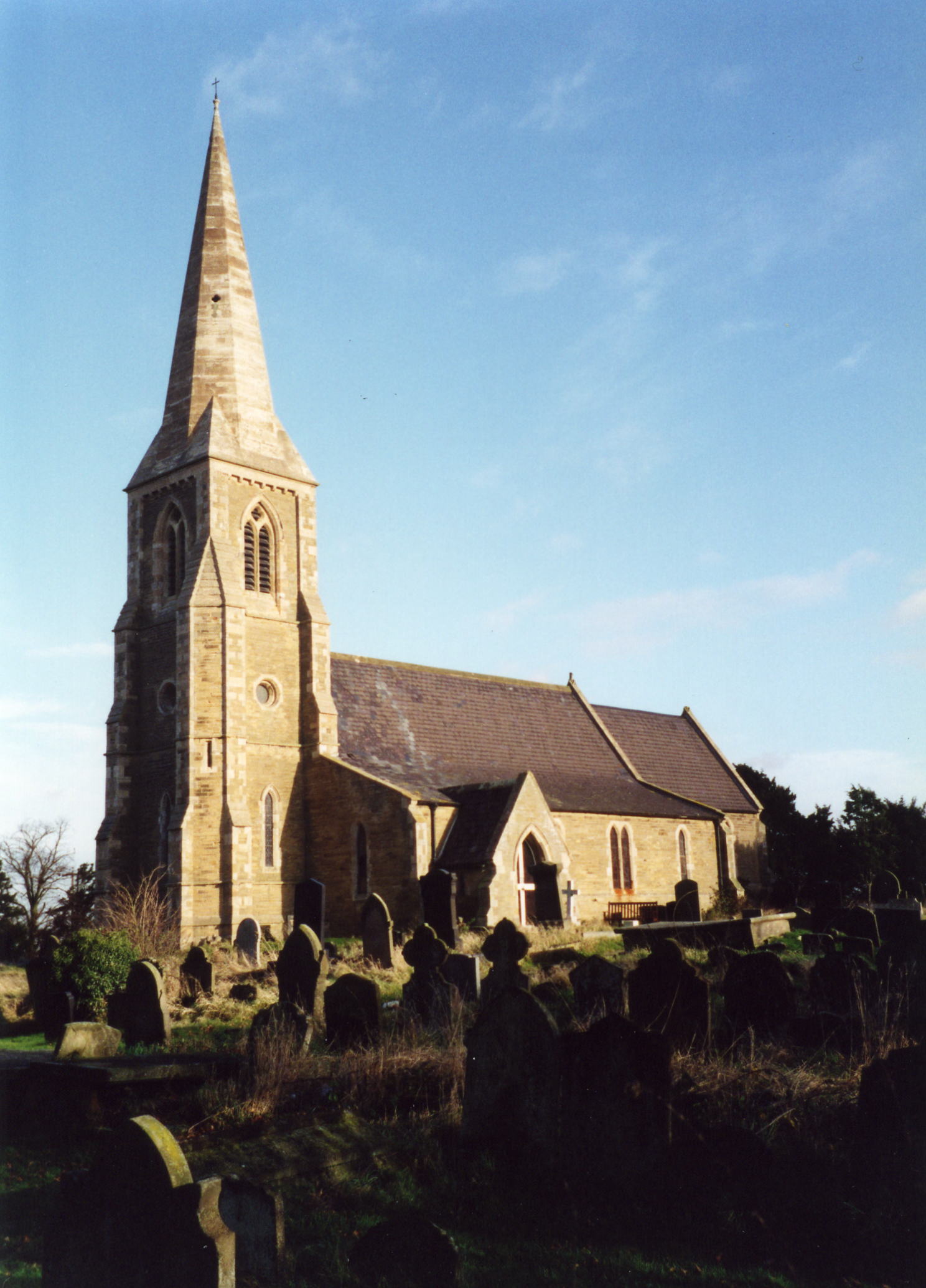
- The Anglican parish church is dedicated to Saint Oswald.
- The church was built about 1/2 mile northwest of the village.
- The old church was falling into ruin, so a new church was built in 1855 to replace it. It opened in July of that year.
- The church seats about 265.
- The church is a Grade II listed building with English Heritage.
- David WRIGHT has a photograph of the Church of St. Oswald on Geo-graph, taken in July, 2007.
- Here is a photo of the church, taken by Ron COLE (who retains the copyright):
- The Anglican parish register dates from 1700.
- The Lincolnshire Family History Society has provided a marriage index for the Isle of Axholme Deanery to make your search easier.
- A Catholic chapel was built in 1877, dedicated to Saint Joseph and Saint Dumphna. David WRIGHT has a photograph of St. Joseph and St. Dumphna on Geo-graph, taken in September, 2006.
- The Primitive Methodists built a chapel here in 1841 and rebuilt it in 1893. The Wesleyan Methodists built a chapel here in 1837. For information and assistance in researching these chapels, see our non-conformist religions page.
- Check our Church Records page for county-wide resources.
- The parish was in the Swinefleet sub-district of the Goole Registration District.
- Check our Civil Registration page for sources and background on Civil Registration which began in July, 1837.
Luddington is one of the eight original parishes in the Isle of Axholme in the far northwest corner of Lincolnshire. Crowle parish lies 5 miles to the south-west and Scunthorpe is 10 miles south-east. The parish covers about 3,700 acres and inlcudes the township of Garthorpe.
Luddington was once a river island, having the Meredyke on the south, the Trent on the east and the Don on the north and west. At the time it was the most northern parish in the Isle of Axholme. If you are planning a visit:
- By automobile, take the B1392 secondary road north out of Althorpe.
- Stop by the Village Hall, here photographed by Jon CLARK on Geo-graph, taken in October, 2005. Ask for a schedule of forth-coming events.
- Visit our touring page for more sources.
- Ask for a calculation of the distance from Luddington to another place.
- Histories and descriptions of Luddington are provided by the Isle of Axholme FHS.
- David WRIGHT has a photograph of the Lincolnshire Arms Public House on Geo-graph, taken in September, 2006.
- The Lincolnshire Arms Public House closed recently and was for sale. There are three Inns listed in the 1842 White's Directory, but the Lincolnshire Arms is not among them. They are: Blue Bell, Friendship and Sheffield Arms. These same three Inns are listed in 1882 as well.
- The first mention we find of the Lincolnshire Arms Public House is in 1930. The publican was Thomas KENNY.
- See our Maps page for additional resources.
You can see maps centred on OS grid reference SE830166 (Lat/Lon: 53.639702, -0.74544), Luddington which are provided by:
- OpenStreetMap
- Google Maps
- StreetMap (Current Ordnance Survey maps)
- Bing (was Multimap)
- Old Maps Online
- National Library of Scotland (Old Ordnance Survey maps)
- Vision of Britain (Click "Historical units & statistics" for administrative areas.)
- English Jurisdictions in 1851 (Unfortunately the LDS have removed the facility to enable us to specify a starting location, you will need to search yourself on their map.)
- Magic (Geographic information) (Click + on map if it doesn't show)
- GeoHack (Links to on-line maps and location specific services.)
- All places within the same township/parish shown on an Openstreetmap map.
- Nearby townships/parishes shown on an Openstreetmap map.
- Nearby places shown on an Openstreetmap map.
David WRIGHT has a photograph of the 1939-1945 Roll of Honour on Geo-graph, taken in July, 2007.
Luddington churchyard has one Commonwealth War Grave from World War II:
- John JACKLIN, lance srgt., Colstream Guards, age 31, died 6 Dec. 1944. Son of Fred and Hannah JACKLIN of Garthorpe.
- In the 1086 Domesday Book, the village name is rendered as Ludintone, from the Old Scandinavian "estate of Luda".
[A. D. MILLS, "A Dictionary of English Place-Names," Oxford University Press, 1991]
- This place was an ancient parish in Lincoln county and became a modern Civil Parish when those were established.
- The parish was in the West division of the ancient Manley Wapentake in the West Lindsey district in the parts of Lindsey.
- In March, 1885, this parish was reduced in size to enlarge Amcotts Civil Parish and Garthorpe Civil Parish.
- In the 1972 government redistricting, Luddington became part of the Boothferry District, which is now in the County of Humberside (formerly Lindsey, Lincolnshire).
- For today's district governance, see the North Lincolnshire Council website.
- Bastardy cases would be heard in the Epworth petty session hearings.
- The Common Lands were enclosed here in 1803.
- Jonathan WORSOP left £2 and 10s. per year for the poor.
- As a result of the 1834 Poor Law Amendment Act, the parish became part of the Goole Poor Law Union.
- A National School was built here in 1849 to accomodate 80 children.
- A Parocial School was built in Garthorpe in 1852 to accomodate 80 children.
- A School Board was established here in 1872.
- A Board School was built in 1874 to replace the 1849 school. It was enlarged in 1891 to hold 90 children.
- See our Schools page for more information on researching school records.
- The local genealogical society is the Isle of Axholme FHS.