
Hide
Ludford
hide
Hide
hide
Hide
hide
Hide
Hide
Hide
The Library at Louth will prove useful in your research.
Also the Community Library at Caistor has a local history archive that will prove valuable.
Tim HEATON has a photograph of the Churchyard at St. Mary's and St. Peter's Church on Geo-graph, taken in January, 2018.
- The parish was in the Binbrook sub-district of the Louth Registration District.
- Check our Census Resource page for county-wide resources.
- The table below gives census piece numbers, where known:
| Census Year | Piece No. |
|---|---|
| 1841 | H.O. 107 / 639 |
| 1851 | H.O. 107 / 2112 |
| 1861 | R.G. 9 / 2384 |
| 1871 | R.G. 10 / 3405 |
| 1891 | R.G. 12 / 2609 |
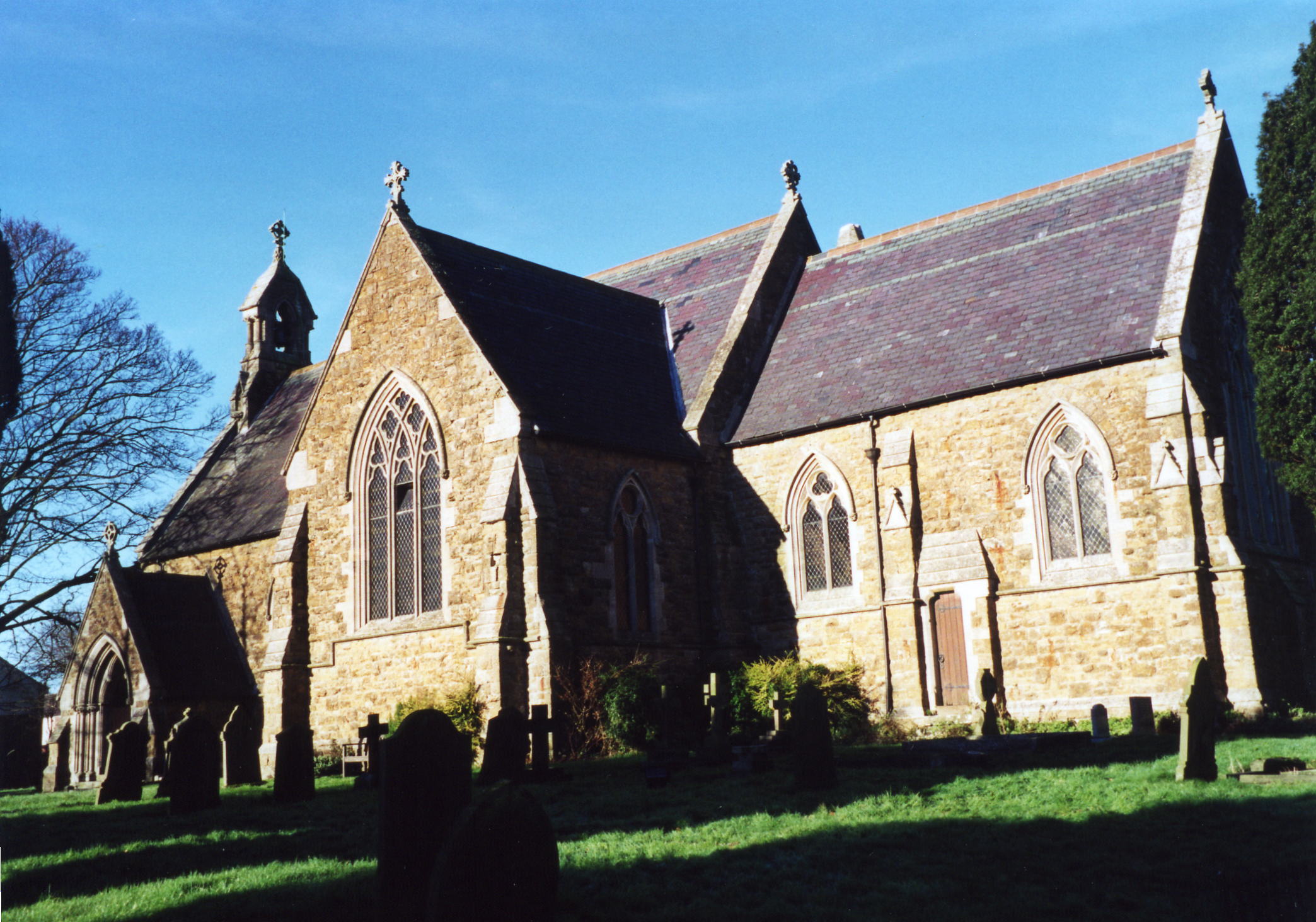
- The Anglican parish church is dedicated to Saints Mary and Peter.
- The church was built of stone and was rebuilt about 1862-64.
- The church seats 358.
- Here is a photo of Saints Mary and Peter's Church, taken by Ron COLE (who retains the copyrights).
- The Anglican parish register dates from 1696.
- The LFHS has published several marriage and burial indexes for the Louth Eske Deanery to make your search easier.
- The church contains the "RAF 101 squadron Roll of Honour".
- Check our Church Records page for county-wide resources.
- Kate NICOL has a photograph of the Former Methodist chapel at Geo-graph, taken in February, 2010.
- The parish was in the Binbrook sub-district of the Louth Registration District.
- Check our Civil Registration page for sources and background on Civil Registration which began in July, 1837.
Ludford is a parish at the north end of the River Bain, west-north-west of Louth and south of Binbrook parish. The parish is in the Wold Hills and covers about 3,300 acres. The parish includes the hamlets of Great Towes and Thorpe le Mire (also known as Thorpe in Mire).
Ludford village consists of the ancient villages of Ludford Magna and Ludford Parva and is bisected by the road between Louth and Gainsborough, now the A631 trunk road. It is at the summit of the Lincolnshire Wolds located about three miles east of Market Rasen. If you are planning a visit:
- Kate NICOL has a nice Winter playground scene at Geo-graph, taken in February, 2010.
- By car, take the A631 between Louth and Gainsborough. Ludford is close to where the B1225 crosses the A631.
- Colin PYLE has a photograph of the Village Sign on Geo-graph, taken in February, 2018.
- Visit our touring page for more sources.
- Ask for a calculation of the distance from Ludford to another place.
- The village was the epicentre of a 27 February 2008 earthquake measuring 5.2 on the Richter scale. Although no buildings were seriously damaged, the quake was felt over a wide area.
- The village holds an annual Christmas Fayre early each December.
- Coaches were built here in the early 1900s.
- Michael PATTERSON has a photograph of the Black Horse Pub at Geo-graph, taken in June, 2006. Mrs. Selina GILBERT was the proprietress in 1930.
- Kate NICOL has a photograph of the sign for the White Hart pub at Geo-graph, taken in February, 2010. Michael J. H. McDONAGH was the proprietor in 1930.
- See our Maps page for additional resources.
You can see maps centred on OS grid reference TF197891 (Lat/Lon: 53.384813, -0.20153), Ludford which are provided by:
- OpenStreetMap
- Google Maps
- StreetMap (Current Ordnance Survey maps)
- Bing (was Multimap)
- Old Maps Online
- National Library of Scotland (Old Ordnance Survey maps)
- Vision of Britain (Click "Historical units & statistics" for administrative areas.)
- English Jurisdictions in 1851 (Unfortunately the LDS have removed the facility to enable us to specify a starting location, you will need to search yourself on their map.)
- Magic (Geographic information) (Click + on map if it doesn't show)
- GeoHack (Links to on-line maps and location specific services.)
- All places within the same township/parish shown on an Openstreetmap map.
- Nearby townships/parishes shown on an Openstreetmap map.
- Nearby places shown on an Openstreetmap map.
- The War Memorial was erected at the edge of the churchyard in June, 1920. The monument is an Ionian cross of Scottish granite on a shaft supported on a single plinth and a base, the cross has a bas relief Celtic knotwork design.
- The RAF opened an airfield called "RAF Ludford Magna" in 1943. They flew Lancaster bombers out of the base. RAF squadron 101 have a reunion every year in early September.
- Although he field had concrete runways, mud was always a problem at the base. It soon earned the nickname "Mudford Magna".
- The field was closed in October 1945.
- In 1956 the field was used as a Polish transit camp.
- The field was re-opened in 1958 and the next year it became a Thor missile site.
- The field was closed again in May 1963 and sold off in October 1965.
- Jonathan THACKER has a photograph of some derelict buildings at the base on Geo-graph, taken in 2011.
John EMERSON, who retains the copyright, provides these photographs of the war memorial at Ludford:
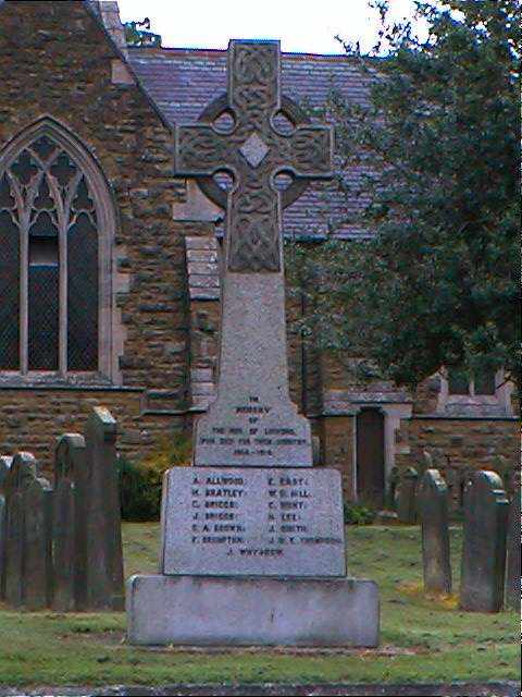
- IaN S. has a photograph of the War Memorial on Geo-graph, taken in February, 2014.
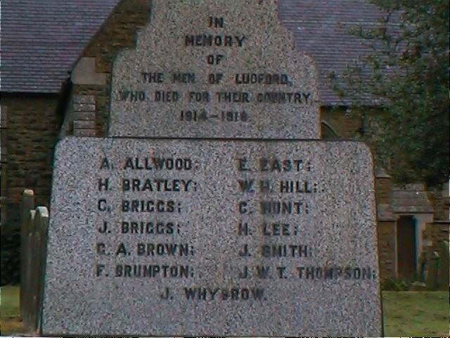
John EMERSON provides this list of names off the war memorial at Ludford:
In memory of the men of Ludford who died for their country 1914-1918
| Name | Notes | Name | Notes |
|---|---|---|---|
| A. ALLWOOD | E. EAST | ||
| H. BRATLEY | W. H. HILL | ||
| C. BRIGGS | C. HUNT | ||
| J. BRIGGS | H. LEE | ||
| G. A. BROWN | J. SMITH | ||
| F. BRUMPTON | J. W. T. THOMPSON | ||
| J. WHYBROW |
- This place was an ancient parish in Lincolnshire and became a modern Civil Parish when those were established.
- The parish was in the ancient Wraggoe Wapentake in the East Lindsey district in the parts of Lindsey.
- For current governance, see the East Lindsey Govt. Council.
- Bastardy cases would be heard in the Wragby petty session hearings on the first Thursday of every month.
- After the 1834 Poor Law Amendment Act reforms, the parish became part of the Louth Poorlaw Union.
- A Public Elementary School was built in 1853 and enlarged in 1907. The school closed in 2009.
- Tim HEATON has a photograph of the old school on Geo-graph, taken in January, 2018.
- For more on researching school records, see our Schools Research page.