
Hide
Martin (by Horncastle)
hide
Hide
hide
Hide
hide
Hide
Hide
Hide
- The parish was in the Horncastle sub-district of the Horncastle Registration District.
- In 1891, we find the parish in the new Tattershall sub-district of the Horncastle Registration District.
- Check our Census Resource page for county-wide resources.
- The table below gives census piece numbers, where known:
| Census Year | Piece No. |
|---|---|
| 1851 | H.O. 107 / 2107 |
| 1861 | R.G. 9 / 2368 |
| 1871 | R.G. 10 / 3382 |
| 1891 | R.G. 12 / 2598 |
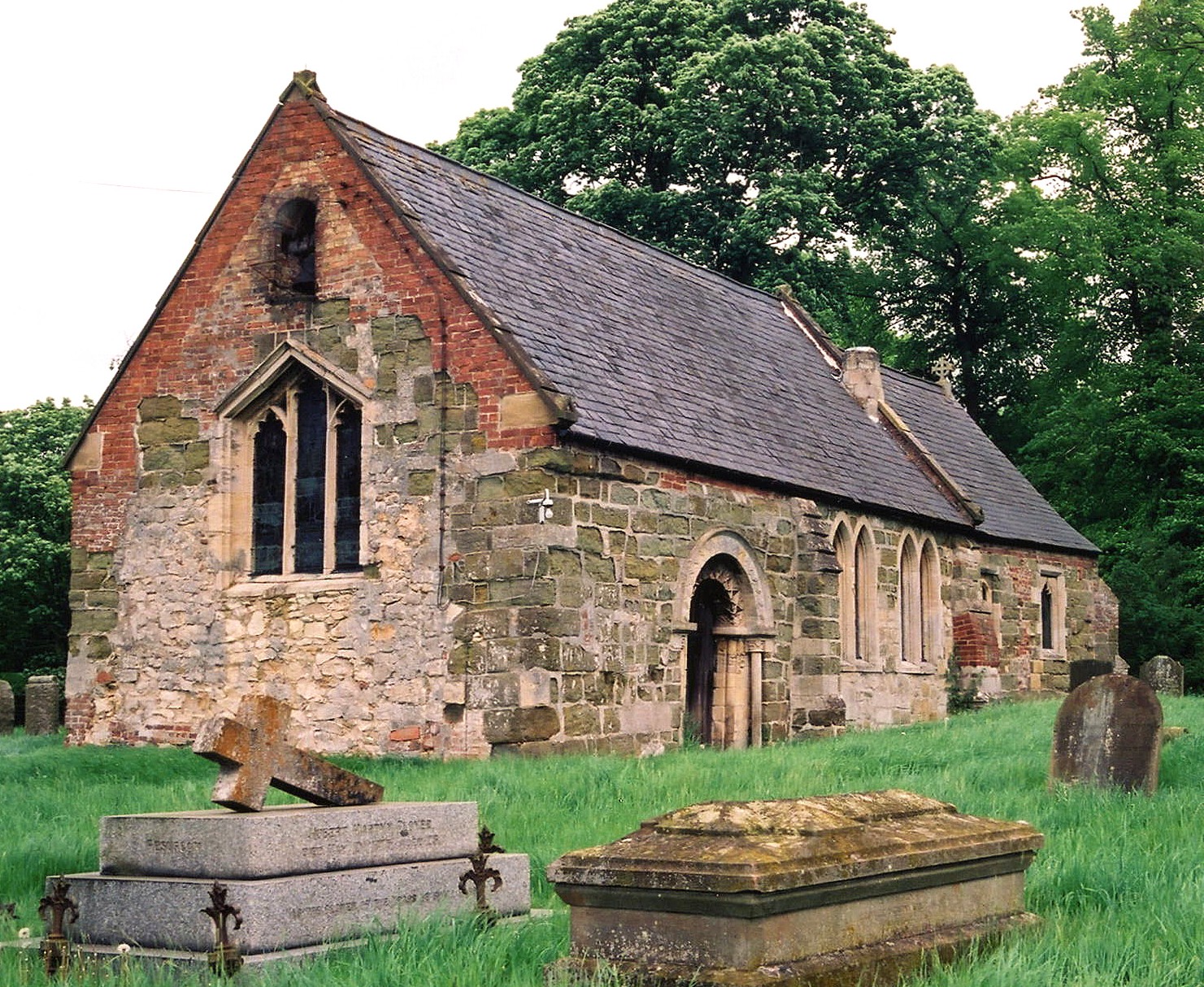
- The Anglican parish church is dedicated to Saint Michael.
- The church is built of stone.
- The church has been dated to 12th century Norman times, but the precise date of origin is unknown.
- The church is small and seats 70.
- There is a photograph of St. Michael's Church on the Wendy PARKINSON Church Photos web site.
- J. HANNAN-BRIGGS has a photograph of St. Michael's Church on Geo-graph, taken in December, 2012.
- Here is a photo of St. Michael's Church, taken by Ron COLE (who retains the copyright):
- The Anglican parish register dates from 1561.
- The LFHS has published several marriage indexes for the Horncastle Deanery to make your search easier.
- Check our Church Records page for county-wide resources.
- The parish was in the Horncastle sub-district of the Horncastle Registration District.
- In 1891, we find the parish in the new Tattershall sub-district of the Horncastle Registration District.
- Check our Civil Registration page for sources and background on Civil Registration which began in July, 1837.
Martin is both a village and a parish, bounded on the west by the River Bain, about 2.5 miles southwest of Horncastle. Woodhall parish lies to the northwest and Kirkstead parish to the south. The parish currently covers 758 acres, but was 844 acres in 1894.
If you are planning a visit:
- Visit our touring page for more sources.
- Ask for a calculation of the distance from Martin (by Horncastle) to another place.
- Martin Hall was the residence of George Robert DAWSON, farmer, in 1900.
- The Manor House in the village was the residence of Thomas HARRISON in 1900.
- The national grid reference is TF 2367.
- You'll want an Ordnance Survey Explorer 273 map, which has 2.5 inches to the mile scale.
- See our Maps page for additional resources.
You can see maps centred on OS grid reference TF239668 (Lat/Lon: 53.183877, -0.147321), Martin (by Horncastle) which are provided by:
- OpenStreetMap
- Google Maps
- StreetMap (Current Ordnance Survey maps)
- Bing (was Multimap)
- Old Maps Online
- National Library of Scotland (Old Ordnance Survey maps)
- Vision of Britain (Click "Historical units & statistics" for administrative areas.)
- English Jurisdictions in 1851 (Unfortunately the LDS have removed the facility to enable us to specify a starting location, you will need to search yourself on their map.)
- Magic (Geographic information) (Click + on map if it doesn't show)
- GeoHack (Links to on-line maps and location specific services.)
- All places within the same township/parish shown on an Openstreetmap map.
- Nearby townships/parishes shown on an Openstreetmap map.
- Nearby places shown on an Openstreetmap map.
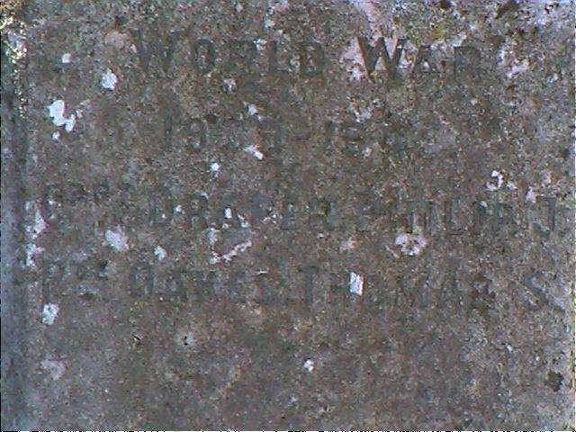
John EMERSON, who retains the copyright, provides these photographs of the war memorial at Martin:

John apologizes because these are so difficult to read. He suggests holding a white sheet of paper up to the monument to reflect sunlight at an angle onto the names:

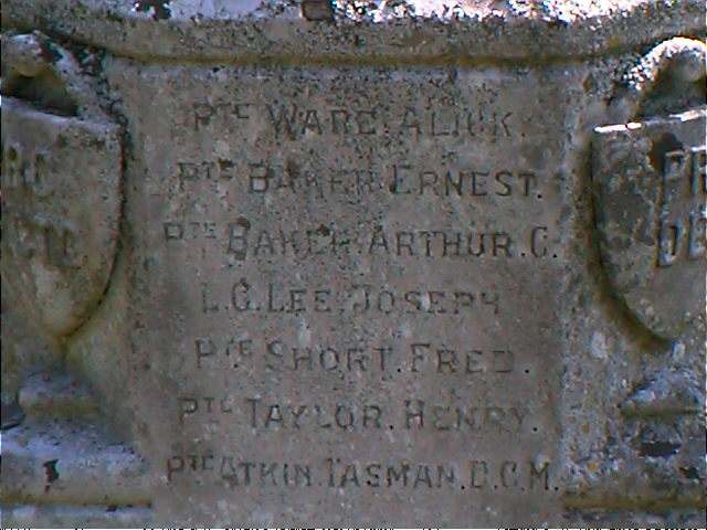
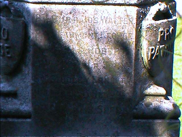
John provides these names:
- World War 1939-1945: Corp. DRAPER Philip J., Pte OAKES Thomas S.
There is one Commonwealth War Grave from World War II in St. Michael's churchyard:
- James McKENZIE, driver, 1st Div. Royal Army Service Corps, age 25, died 14 Oct. 1941. Husband of Edith Joan.
For a list of names on the Memorial, see the Roll of Honour site.
- This place was an ancient parish of Lincolnshire and became a modern Civil Parish when those were established.
- On 24 December, 1880, a portion of this parish was taken to enlarge Langriville Civil Parish.
- In 1894, a portion of this parish was taken to help form the new civil parish of Woodhall Spa (by Local Government Board Order No. 31,760, dated Sept. 17, 1894).
- The parish was in the south division of the ancient Gartree Wapentake in the East Lindsey district in the parts of Lindsey.
- Kelly's 1900 Directory of Lincolnshire places the parish, perhaps erroneously, in the South Lindsey district of the county.
- This Civil Parish was abolished on 1 April, 1936, and all 758 acres were amalgamated into Roughton Civil Parish.
- For today's district governance, see the East Lindsey District Council.
- Bastardy cases would be heard in the Horncastle petty session hearings.
- As a result of the 1834 Poor Law Amendment Act, the parish became part of the Horncastle Poor Law Union7.
Year Inhabitants 1801 41 1811 33 1821 55 1831 60 1841 58 1851 74 1871 82 1881 70 1891 117 1901 52 1911 55 1921 45 1931 41
- The children of this parish attended school at Roughton.
- For more on researching school records, see our Schools Research page.