
Hide
Metheringham
hide
Hide
hide
Hide
hide
Hide
Hide
hide
Hide
Hide
- The parish is in the South West sub-district of the Lincoln Registration District.
- Check our Census Resource page for county-wide resources.
- The table below gives census piece numbers, where known:
| Census Year | Piece No. |
|---|---|
| 1841 | H.O. 107 / 620-621 |
| 1871 | R.G. 10 / 3368 |
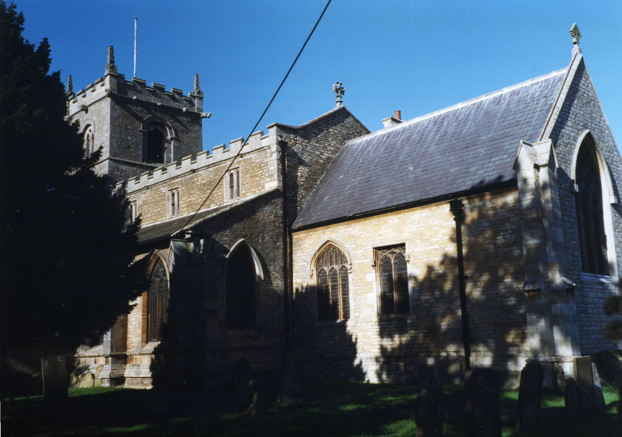
- The Anglican parish church is dedicated to St. Wilfrid (also given as "Wilfred").
- The church appears to date from the 13th century, but the old church burnt down in 1599. It was restored in 1603.
- The new church seats about 450.
- There is a photograph of St. Wilfrid's Church on the Wendy PARKINSON Church Photos web site.
- Here is a photo of St. Wilfrid's Church, taken by Ron COLE (who retains the copyright):
- The Anglican parish register dates from 1538.
- We have a handful of entries in our Parish Register Extract text file. Your additions are welcome.
- The Lincolnshire FHS has published several marriage indexes and a burial index for the Graffoe Deanery to make your search easier.
- There was a Wesleyan Methodist chapel built here in Tanvats in 1887. The Wesleyans built a cahpel in Metheringham village in 1840. The Primitive Methodists built their chapel in the village in 1850, as did the Reform Methodists. For information and assistance in researching these chapels, see our non-conformist religions page.
- Check our Church Records page for county-wide resources.
- The parish is in the South West sub-district of the Lincoln Registration District.
- Check our Civil Registration page for sources and background on Civil Registration which began in July, 1837.
Metheringham is both a village and a parish 10 miles southeast of the city of Lincoln and 10 miles north of Sleaford. Dunston parish lies to the north and Blankney parish to the south. The parish covers about 5,900 acres and includes the hamlet of Tanvats, which lies about 4 miles east of the village.
The large village of Metheringham almost merges with Blankney village to the south. If you are planning a visit:
- Take the A15 south out of Lincoln and turn left onto the B1202 trunk road. You should be heading easterly. When you are at the B1188 junction, the village should be in front of you and to the right.
- The Metheringham Delph nature preserve is located at Tanvats hamlet.
- The Railway station is on Station Road (the B1189). There is a photograph on Wikipedia.
- See our transport page for bus and train schedules.
- See our touring page for more sources.
- Ask for a calculation of the distance from Metheringham to another place.
- The village is mentioned in the 1086 Domesday Book.
- There had been an ancient cross which stood in the village, but it was replaced by a new one in 1835.
- The parish was drained by the use of a 25-horsepower steam engine. The drainage caused the spring Holywell to stop flowing.
- In 1841, the village hosted a Sick Club and a Cow Club.
- For a history of individual buildings and structures, see Metheringham Highlights website.
- Metheringham Manor was built in the 17th century and badly damaged by fire in the 19th century.
- The Old Hall was divided into tenements by 1841.
- The Manor house was requisitioned by the RAF in 1942 until the end of World War II.
- Metheringham Cottage is the name of the mansion 6 miles southeast of Lincoln.
- See our Maps page for additional resources.
You can see maps centred on OS grid reference TF069615 (Lat/Lon: 53.139938, -0.403374), Metheringham which are provided by:
- OpenStreetMap
- Google Maps
- StreetMap (Current Ordnance Survey maps)
- Bing (was Multimap)
- Old Maps Online
- National Library of Scotland (Old Ordnance Survey maps)
- Vision of Britain (Click "Historical units & statistics" for administrative areas.)
- English Jurisdictions in 1851 (Unfortunately the LDS have removed the facility to enable us to specify a starting location, you will need to search yourself on their map.)
- Magic (Geographic information) (Click + on map if it doesn't show)
- GeoHack (Links to on-line maps and location specific services.)
- All places within the same township/parish shown on an Openstreetmap map.
- Nearby townships/parishes shown on an Openstreetmap map.
- Nearby places shown on an Openstreetmap map.
- During 1942 and 1943 a Class "A" airfield was built here (and partially in Martin parish) for the RAF. It covered 400 acres and opened in October, 1943, as RAF Metheringham.
- The airfield closed in 1946.
- Most of the buildings were demolished or removed by 1970. The remaining structures were given over to commercial use.
- Stop by the Visitor Centre for more information.
- Tanvats is in Metheringham parish, in the Fen on the bank of a long drain, called Metheringham Delph. The name is self-explanatory; it was a tannery, vats being used for steeping (soaking) the skins. This usually took place a long way from a village because of the obnoxious smell. About 70 years ago there was a small but lively community which had grown up there. It is still isolated, and now almost deserted although it used to have a thriving Methodist chapel, and a school. It had a beer house which the locals said had the longest bar in the country - they had to drink on the bank of the drain! There is a bridge connecting it with Blankney, jocularly know as Tanvats Pier! The inhabitants had a sense of humour! ["tinribs," 2001].
- Locals often refer to the parish as "Meg" ["Anne Cole," 2007].
- This place was an ancient parish in Lincolnshire and became a modern Civil Parish when those were established.
- The parish was in the ancient Langoe Wapentake in the North Kesteven division of the county, in the parts of Kesteven.
- For today's parish governance, see the Metheringham Parish Council.
- For today's district governance, see the North Kesteven District Council.
- Bastardy cases would be heard at the Lincoln South petty session hearings.
- A Mr. COLLEY left almost 4 acres of land for the poor (undated).
- In 1829, John ELLIS left an annuity of £3 for the poor.
- As a result of the 1834 Poor Law Amendment Act reforms, the parish became part of the Lincoln Poor Law Union.
Year Inhabitants 1801 536 1811 601 1821 626 1831 880 1841 1,197 1851 1,522 1871 1,652 1881 1,857 1891 1,614 1901 1,517 1911 1,526 1921 1,447
- A Church of England School was built here in 1840 as a Reading Room. It was purchased by Henry CHAPLIN and presented to the parish, upon which it became a school. It was enlarged in 1883 to hold 200 children.
- A Wesleyan Church School was built in 1840 to hold 146 children.
- A Church of England School was built at Tanvats in 1840 to hold 76 children.
- For more on researching school records, see our Schools Research page.