
Hide
North Kelsey
hide
Hide
hide
Hide
hide
Hide
Hide
Kelsey, North, par. and vil. with ry. sta., Lincolnshire, 6 miles S. of Barnetby sta., and 23½ miles NE. of Lincoln, 5,370 ac., pop. 844; P.O.; 1 mile NE. of vil. is the hamlet of Kelsey North End.
From: John BARTHOLOMEW's "Gazetteer of the British Isles (1887)"
Hide
The Caistor Library is an excellent resource with a Local History section and a Family History section.
- The Cemetery was established in 1889 under the control of the parish council's Burial Board.
- The Cemetery covers just over one acre and has a mortuary chapel.
- David WRIGHT has a photograph of the Cemetery Chapel on Geo-graph, taken in September, 2006.
- J. THOMAS has a photograph of All Hallows Churchyard cemetery on Geo-graph, taken in June, 2013.
- The parish was in the Caistor sub-district of the Caistor Registration District.
- Check our Census Resource page for county-wide resources.
- The table below gives census piece numbers, where known:
| Census Year | Piece No. |
|---|---|
| 1841 | H.O. 107 / 638 |
| 1851 | H.O. 107 / 2114 |
| 1861 | R.G. 9 / 2393 |
| 1871 | R.G. 10 / 3421 |
| 1881 | R.G. 11 / 3280 |
| 1891 | R.G. 12 / 2622 |
| 1901 | R.G. 13 / 3098 |
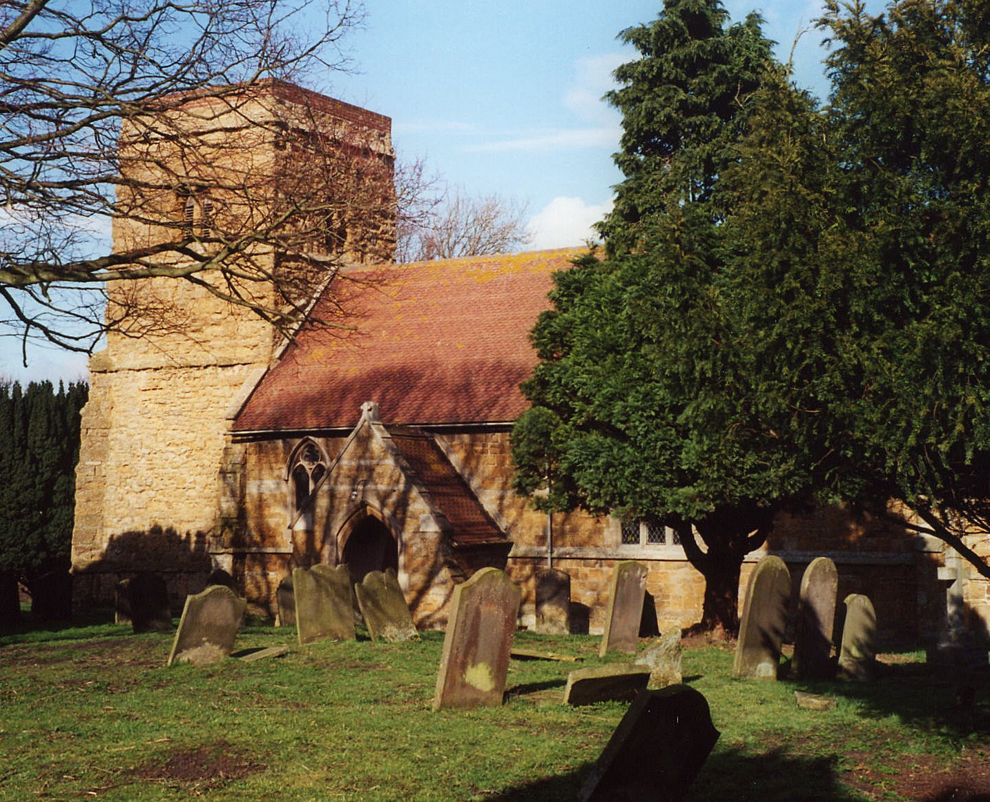
- The Anglican parish church was dedicated to Saint Nicholas.
- The church dedication was changed to All Hallows in the late Victorian era.
- The church tower dates from the 13th century.
- The church, with the exception of the tower, was thoroghly restored in 1869.
- The church tower was dmaged by a tornado-like windstorm in 1930.
- The church seats 300.
- A Mission church was erected on the Moor in 1873. It can seat 60.
- A photograph of St. Nicholas church is at the Wendy PARKINSON English Church Photographs site.
- Richard CROFT has a photograph of the church chancel on Geo-graph, taken in November, 2009.
- Here is a photo of All Hallows Church, taken by Ron COLE (who retains the copyright):
- The Anglican parish register dates from 1612.
- The Anglican parish register is reported to be in very bad condition up to 1711 and seems to be missing the period 1686-1711.
- We have the beginning of a Parish Register Extract in text form for your use. Your additions are welcome.
- The Lincolnshire FHS has published several marriage indexes and a burial index for the Yarborough Deanery to make your search easier.
- The east window of the the parish church's north aisle is a memorial to Maria, wife of William Frederick CHAMBERS.
- There was a Wesleyan Methodist chapel built in 1848 and rebuilt in 1898. The Primitive methodists built a chapel in 1882. For more on researching these chapel records, see our non-conformist religions page.
- David WRIGHT has a photograph of the Methodist Church on Geo-graph, taken in September, 2006. It is mis-identified as South Kelsey.
- Check our Church Records page for county-wide resources.
- The parish was in the Caistor sub-district of the Caistor Registration District.
- Check our Civil Registration page for sources and background on Civil Registration which began in July, 1837.
This village and parish sit on a branch of the River Ancholme called the North Kelsey Beck. The village lies 160 miles north of London, about 4 miles west of Caistor and 6 miles southeast of Brigg. The parish covers 6,227 acres.
If you are planning a visit:
- The adjacent village of Hibaldstow, to the west, is reached by crossing Hibaldstow Bridge, an iron lattice girder bridge, built in 1889, that spans the River Ancholme.
- The railway came to North Kelsey in 1848 and closed in 1965.
- Visit our touring page for visitor services.
- Ask for a calculation of the distance from North Kelsey to another place.
- Richard CROFT has a photograph of the Village Pump on Geo-graph, taken in June, 2013. The pump is dated 1891.
- In 1842, there were only two pubs listed in the parish.
- David WRIGHT has a photograph of the Royal Oak Public House on the High Street on Geo-graph, taken in September, 2006.
- The Royal Oak Public House is a popular conversation spot. At last report, the Inn was for sale.
- These are the names associated with the Royal Oak in various directories:
| Year | Proprietor |
|---|---|
| 1842 | John ELLERBY, butcher & vict. |
| 1868 | Charles KENNINGTON, wheelwright |
| 1872 | -- not listed -- |
| 1882 | James MARSHALL, vict. |
| 1900 | Charles Henry WOOD |
| 1913 | Thomas Wilkinson CAPES |
| 1919 | Francis GARRETTY |
| 1930 | Tom FOX |
- The other Pub. in the village is The Butcher's Arms.
- Neil THEASBY has a photograph of The Butchers Arms on Geo-graph, taken in November, 2021.
- See our Maps page for additional resources.
You can see maps centred on OS grid reference TA044015 (Lat/Lon: 53.499845, -0.427575), North Kelsey which are provided by:
- OpenStreetMap
- Google Maps
- StreetMap (Current Ordnance Survey maps)
- Bing (was Multimap)
- Old Maps Online
- National Library of Scotland (Old Ordnance Survey maps)
- Vision of Britain (Click "Historical units & statistics" for administrative areas.)
- English Jurisdictions in 1851 (Unfortunately the LDS have removed the facility to enable us to specify a starting location, you will need to search yourself on their map.)
- Magic (Geographic information) (Click + on map if it doesn't show)
- GeoHack (Links to on-line maps and location specific services.)
- All places within the same township/parish shown on an Openstreetmap map.
- Nearby townships/parishes shown on an Openstreetmap map.
- Nearby places shown on an Openstreetmap map.
- In the cemetery, near the mortuary chapel, is a stone celtic cross in memory of the men of the village who died in World War I. It was dedicated in September 1920.
- John FIRTH has a photograph of the War Memorial on Geo-graph, taken in July, 2010.
- The former RAF Caistor is chiefly within this parish, and the concrete bases of three Thor IRBM launch pads are the only things that remain.
For a photograph of the North Kelsey War Memorial and the list of names on it, see the Roll of Honour site.
There is one Commonwealth War Grave in North Kelsey Cemetery from World War II:
- Cyril BARRICK, aircftman 1st, RAF Vol. Rsrv., age 18, died 28 May 1940. Son of George William and Frances BARRICK.
- This place was an ancient parish in Lincolnshire and became a modern Civil Parish when those were established.
- The parish was in the south division of the ancient Yarborough Wapentake in the West Lindsey district in the parts of Lindsey.
- On 24 March, 1887, this parish was enlarged by gaining Twelve Month Hill and part of Round Farm from Searby cum Ownby Civil Parish.
- Stop by the Village Hall on School Lane when it is open and ask to see the schedule of forth-coming events. Such halls often have local history talks.
- Kelly's 1900 Directory of Lincolnshire places the parish, perhaps erroneously, in the North Lindsey district of the county.
- Today's district governance is provided by the West Lindsey District Council.
- Bastardy cases would be heard in the Caistor petty session hearings.
- After the 1834 Poor Law Amendment Act reforms, the parish became part of the Caistor Poor Law Union.
- The parish had Lord Carrington's Charity which, in 1919, provided £100 for distribution to poor pensioners.
- There are no Poorlaw records on file at the Lincs Archives for this parish.
- A Council School was built here in 1896 to hold up to 180 children.
- For more on researching school records, see our Schools Research page.