
Hide
Quarrington
hide
Hide
hide
Hide
hide
Hide
Hide
hide
- Maps
- Medical Records
- Migration, Internal◬
- Military History◬
- Military Records
- Names, Geographical◬
- Names, Personal◬
- Naturalisation & Citizenship◬
- Newspapers◬
- Occupations◬
- Politics & Government
- Poor Houses, Poor Law
- Population
- Postal & Shipping Guides◬
- Probate Records◬
- Public Records◬
- Schools
- Societies◬
- Voting Registers◬
Hide
Hide
- The parish was in the Sleaford sub-district of the Sleaford Registration District.
- Check our Census Resource page for county-wide resources.
- The table below gives census piece numbers, where known:
| Census Year | Piece No. |
|---|---|
| 1841 | H.O. 107 / 621 |
| 1861 | R.G. 9 / 2343 |
| 1871 | R.G. 10 / 3350 |
| 1891 | R.G. 12 / 2578 |
- At the time of the 1086 Domesday Book, there were two churches here.
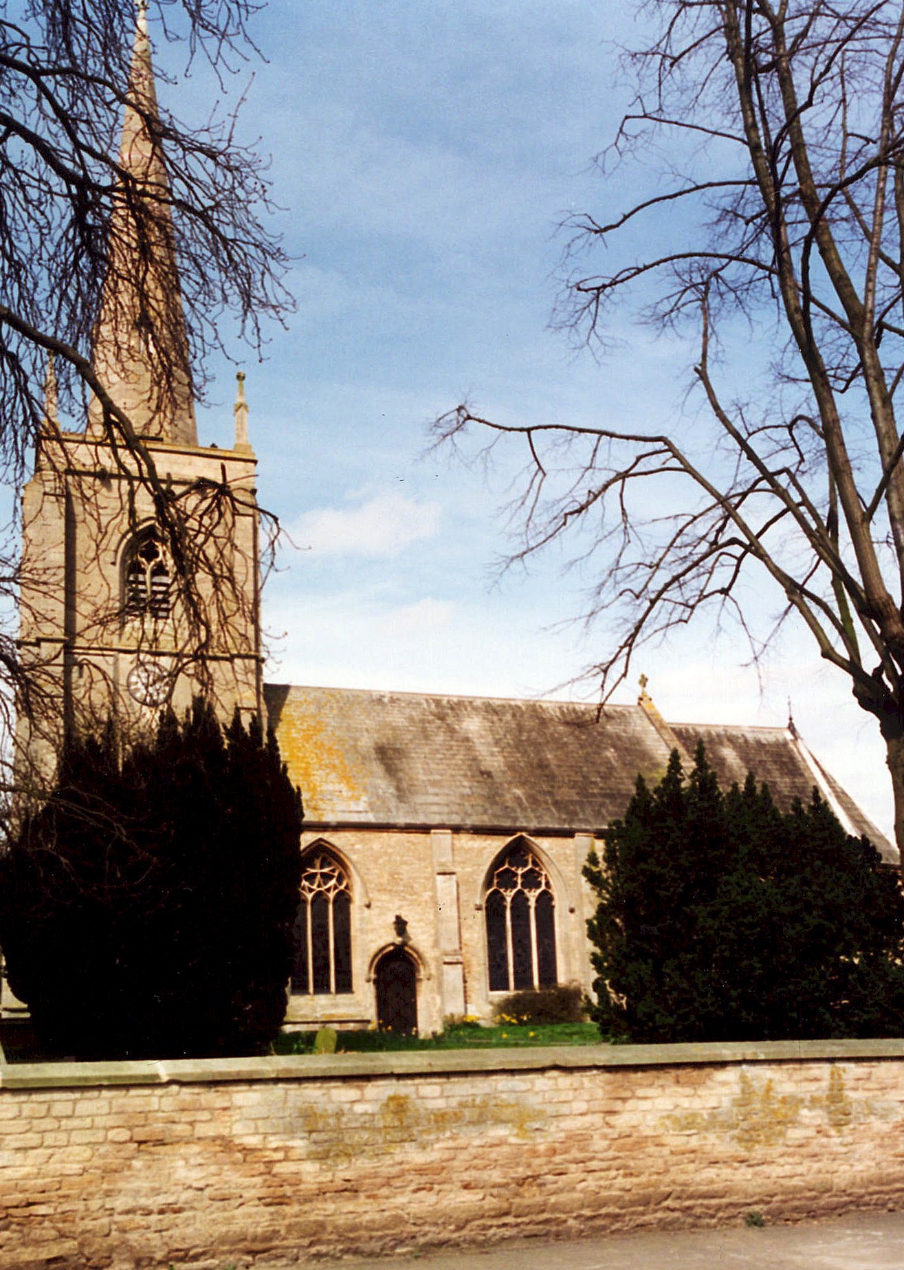
- The Anglican parish church is dedicated to Saint Botolph and is built of Ancaster stone.
- The church was built in the 13th century.
- The church was rebuilt on a smaller scale circa 1812.
- The church tower was restored in 1887.
- The church seats about 220.
- A photograph of Saint Botolph's church is at the Wendy PARKINSON English Church Photographs site.
- Here is a photo of St. Botolph's Church, taken by Ron COLE (who retains the copyright):
- The parish register dates from 1558, but there are no marriages recorded from 1642 until 1648.
- We have the beginning of a partial extract of baptisms from the Quarrington parish register.
- The Lincolnshire FHS has a Loan Library service which has the parish registers on microfiche for Baptisms from 1558 to 1812 and Marriages from 1558 to 1815.
- The LFHS has published several marriage and burial indexes for the Lafford Deanery to make your search easier.
- Check our Church Records page for county-wide resources.
- The parish was in the Sleaford sub-district of the Sleaford Registration District.
- Check our Civil Registration page for sources and background on Civil Registration which started in July, 1837.
Quarrington is both a parish and a hamlet on the south-west side of the town of Sleaford. The parish covers about 1,470 acres. At the beginning of the 20th century, this was sheep country.
If you are planning a visit:
- By automobile, Quarrington is just to the east of the A15 motor way as it passes south of Sleaford, near the intersection with A153 trunk road.
- Richard CROFT provides a photograph of the Milepost on Grantham Road on Geo-graph, taken in November, 2010.
- See our touring page for more sources.
- Ask for a calculation of the distance from Quarrington to another place.
- See our "Maps" page for additional resources.
You can see maps centred on OS grid reference TF058447 (Lat/Lon: 52.989267, -0.424948), Quarrington which are provided by:
- OpenStreetMap
- Google Maps
- StreetMap (Current Ordnance Survey maps)
- Bing (was Multimap)
- Old Maps Online
- National Library of Scotland (Old Ordnance Survey maps)
- Vision of Britain (Click "Historical units & statistics" for administrative areas.)
- English Jurisdictions in 1851 (Unfortunately the LDS have removed the facility to enable us to specify a starting location, you will need to search yourself on their map.)
- Magic (Geographic information) (Click + on map if it doesn't show)
- GeoHack (Links to on-line maps and location specific services.)
- All places within the same township/parish shown on an Openstreetmap map.
- Nearby townships/parishes shown on an Openstreetmap map.
- Nearby places shown on an Openstreetmap map.
- The Kesteven County Asylum was erected here, near the border with Rauceby. Please see our Poor Law Asylum page for more information.
For a photograph of the Quarrington War Memorial plaques and the names on them, see the Roll of Honour site.
- This place was an ancient parish in Lincoln county and became a modern Civil Parish when those were established.
- The parish was in the ancient Aswardhurn Wapentake in the North Kesteven division of the county, parts of Kesteven.
- In March, 1888, this Civil Parish gained a portion of Old Sleaford Civil Parish.
- For today's district governance, contact the North Kesteven District Council.
- Bastardy cases would be heard in the Sleaford petty session hearings every Monday.
- In 1718, Dame Margaret THOROLD left £5 yearly for distribution among the poor of this parish.
- The Common Land was enclosed here in 1796.
- After the Poor Law Amendment Act reforms of 1834, the parish became part of the Sleaford Poor Law Union.
The surge in population around 1840 is due to the new railways and the draining of Fen land.
The surge in population around 1900 is due to the growth of Sleaford, to the north, and the building of the county lunatic asylum.
Year Inhabitants 1801 101 1841 236 1851 264 1871 340 1881 364 1891 454 1901 865 1911 1,649 1921 1,709
- The Public Elementary School was built in 1868 and later enlarged to hold 190 children.
- For more on researching school records, see our Schools Research page.