
Hide
Ruckland
hide
Hide
hide
Hide
hide
Hide
Hide
Hide
The Library at Louth will prove useful in your research.
Rde HEALTH has a photograph of St. Chad's churchyard on Geo-graph, taken in August, 2014.
- The parish was in the Louth sub-district of the Louth Registration District.
- Check our Census Resource page for county-wide resources.
- The table below gives census piece numbers, where known:
Census
YearPiece No. 1851 H.O. 107 / 2111 1861 R.G. 9 / 2381 1871 R.G. 10 / 3404 1881 R.G. 11 / 3263 1891 R.G. 12 / 2608 1901 R.G. 13 / 3084
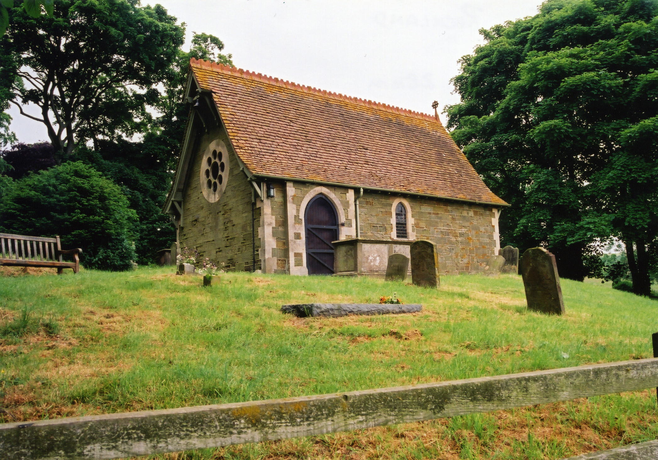
- The first church on this site was probably built between 1030 and 1086.
- The Anglican parish church was dedicated to Saint Olave (alternately "St. Olaf"). It is one of the smallest churches in all Lincolnshire.
- The church was rebuilt in 1861 usin stones from the earlier structure..
- The church is a Grade II listed structure with English Heritage.
- The church seats only 40.
- The church was rebuilt in 1885 of sandstone. It has a small western turret with one bell.
- White's 1872 Directory tells us that the church was dedicated to St. Clare. This is corrected in Kelly's 1900 Directory.
- There is a photograph of St. Olave Church on the Wendy PARKINSON Church Photos web site.
- Here is a photo of Saint Olave's Church, taken by Ron COLE (who retains the copyright):
- The Anglican parish register dates from 1757 and includes entries from Worlaby parish.
- The Lincolnshire FHS has published several Marriage indexes and a Burial index for the Bolingbroke Deanery to make your search easier.
- Check our Church Records page for county-wide resources.
- The parish was in the Louth sub-district of the Louth Registration District.
- Check our Civil Registration page for sources and background on Civil Registration which began in July, 1837.
Ruckland is both a village and a parish about 6 miles south of Louth. The parish covers only about 610 acres.
If you are planning a visit, see:
- By automobile, take the A15 trunk road south out of Louth or north from Spilsby. Turn west at Burwell and proceed about one mile to the village.
- See our touring page for visitor services.
- Ask for a calculation of the distance from Ruckland to another place.
- See our Maps page for additional resources.
You can see maps centred on OS grid reference TF334781 (Lat/Lon: 53.283536, -0.000429), Ruckland which are provided by:
- OpenStreetMap
- Google Maps
- StreetMap (Current Ordnance Survey maps)
- Bing (was Multimap)
- Old Maps Online
- National Library of Scotland (Old Ordnance Survey maps)
- Vision of Britain (Click "Historical units & statistics" for administrative areas.)
- English Jurisdictions in 1851 (Unfortunately the LDS have removed the facility to enable us to specify a starting location, you will need to search yourself on their map.)
- Magic (Geographic information) (Click + on map if it doesn't show)
- GeoHack (Links to on-line maps and location specific services.)
- All places within the same township/parish shown on an Openstreetmap map.
- Nearby townships/parishes shown on an Openstreetmap map.
- Nearby places shown on an Openstreetmap map.
Wikipedia tells us that the "churchyard contains the war graves of a Royal Navy sailor and an Army Veterinary Corps soldier of the Second World War."
- This place was an ancient parish in Lincoln county and became a modern Civil Parish when those were established.
- The parish was in the ancient Louth Eske Wapentake in the East Lindsey district in the parts of Lindsey.
- In 1936, the Civil Parish was abolished and made part of the Maidenwell Civil Parish.
- For today's governance, see the East Lindsey District Council.
- Bastardy cases would be heard in the Louth petty session hearings every other Wednesday.
- In 1719, Mr. Chas. HUMPHREYS left the interest on £30 for the poor.
- After the Poor Law Amendment Act of 1834, this parish became part of the Louth Poor Law Union.
- The children of this parish attended school in Farforth parish, to the northeast.
- See our Schools page for more information on researching school records.