
Hide
Ruskington
hide
Hide
hide
Hide
hide
Hide
Hide
Hide
- In 1871 a Saxon cemetery was found about 20 yards north of the windmill.
- A cemetery of 1 acre was formed in 1882 and managed by the burial board of the Parish Council.
- Richard CROFT has a photograph of the Lych gate on Geo-graph, taken in February, 2008.
- The parish was in the Sleaford sub-district of the Sleaford Registration District.
- Check for ancestors on our 1901 Census Surname Extract. This extract is incomplete.
- Check our Census Resource page for county-wide resources.
- The table below gives census piece numbers, where known:
| Census Year | Piece No. |
|---|---|
| 1841 | H.O. 107 / 621 |
| 1861 | R.G. 9 / 2342 |
| 1871 | R.G. 10 / 3349 |
| 1881 | R.G. 11 / 3222 |
| 1891 | R.G. 12 / 2577 |
| 1901 | R.G. 13 / 3048 |
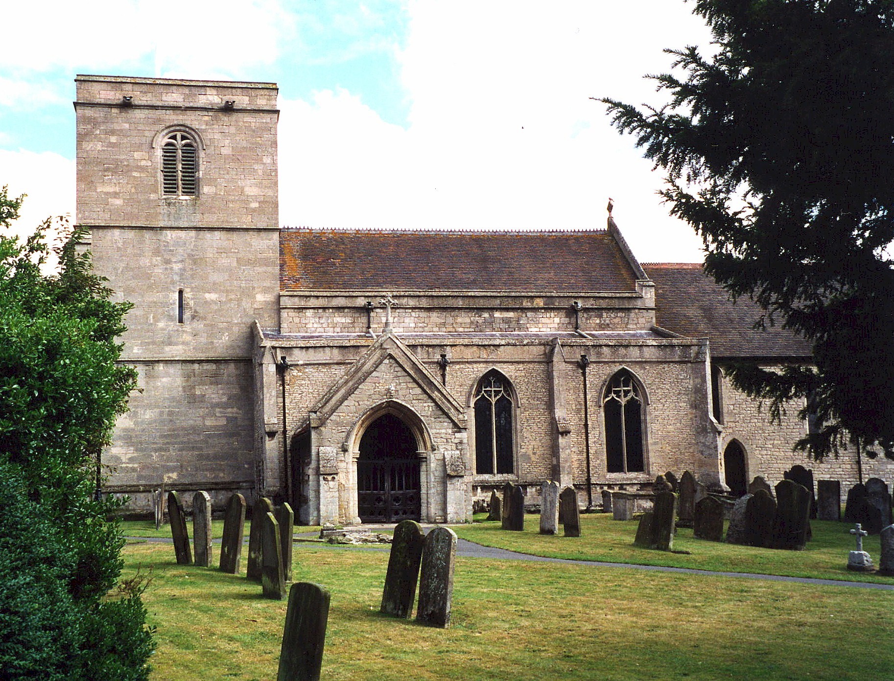
- The Anglican parish church is dedicated to All Saints.
- Parts of the church tower are believed to be from Norman times. The Chancel portion of the church is over 700 years old.
- The church spire fell down around 1620. The tower was subsequently rebuilt and the spire reinstalled.
- The church was reseated and restored in 1861.
- The church chancel was lengthened in 1873.
- Richard CROFT has a photograph of All Saints' church porch on Geo-graph, taken in February, 2008.
- There is a photograph of the Anglican parish church on the Wendy PARKINSON Church Photos web site.
- Here is a photo of All Saints Church, taken by Ron COLE (who retains the copyright):
- The Anglican parish register dates from 1558.
- We have a partial extract from the Ruskington parish register. Your additions are welcome.
- The Lincolnshire FHS has a Loan Library service which has the parish registers on microfiche for Baptisms from 1668 to 1812 and Marriages from 1668 to 1812.
- The LFHS has published several marriage and burial indexes for the Lafford Deanery to make your search easier.
- The Wesleyan Methodists had a chapel here, erected in 1849. The Reform Methodists also had a chapel here. For information and assistance in researching these chapels, see our non-conformist religions page.
- Richard CROFT also has a photograph of Zion Wesleyan Reform Chapel on Geo-graph, taken in February, 2008.
- Check our Church Records page for county-wide resources.
- The parish was in the Sleaford sub-district of the Sleaford Registration District.
- Check our Civil Registration page for sources and background on Civil Registration which started in July, 1837.
This village and large parish are 114 miles north of London, 4 miles north-east of Sleaford, just off the A153 road. Anwick parish is to the south-east and Dorrington parish to the north. The parish covers almost 4,000 acres.
If you are planning a visit:
- By automobile, take the A153 arterial road north out of Sleaford, then turn left to the B1188 road into Ruskington village.
- Take a Ruskington Photo Tour.
- Visit our touring page for more sources.
- Ask for a calculation of the distance from Ruskington to another place.
- The village held an annual feast in the week of the first Sunday in November.
- A Temperance Hall was built here in 1857. It was later converted into use as a Church Hall.
- The Railway came to Ruskington in 1882 when a line opened to Spalding. Later that same year a line was opened to Lincoln.
- Richard CROFT has a photograph of the Black Bull Inn on Geo-graph, taken in May, 2006.
- Here are the names of the owners/managers of the Black Bull P. H. taken from various Directories:
| Year | Person |
|---|---|
| 1842 | Zaccheus PRINCE, vict. |
| 1872 | Thos. PRINCE, victualler |
| 1882 | Thomas PRINCE, vict. |
| 1900 | Mrs. Louisa J. PRINCE |
| 1913 | Frederick Herbert SHAW, farmer |
| 1930 | William B. SPRATT |
- Richard CROFT also has a photograph of The Red Lion Inn on Geo-graph, taken in February, 2008.
- Here are the names of the owners/managers of the Red Lion on High Street taken from various Directories:
| Year | Person |
|---|---|
| 1842 | Wm. TUXFORD, vict. |
| 1872 | Edward ULLYATT, victualler |
| 1882 | Mrs. Mary Ann THORPE, vict. |
| 1900 | Jn. Wm. JOYCE, butcher |
| 1913 | Herbert GRAY |
| 1930 | Marmeduke Fras. SHEPHERD |
The 1881 census gives the following information on the above Public House, reference RG 11/3222, folio 42. Mary Ann is listed as a widow:
Relationship Name Sex Age Where born Head Mary Ann THORPE F 35 Ruskington, Lincolnshire sister Sarah MARSHALL F 25 Ruskington, Lincolnshire brother Charles ULYATT M 16 Ruskington, Lincolnshire sister Alice THORPE F 11 Ruskington, Lincolnshire
- The Shoulder of Mutton Public House on Church Street has been around for over 100 years.
- Here are the names of the owners/managers of the Shoulder of Mutton taken from various Directories:
| Year | Person |
|---|---|
| 1842 | -- not listed -- |
| 1872 | -- not listed -- |
| 1882 | -- not listed -- |
| 1900 | Mrs. Nancy BALDOCK |
| 1913 | George Henry THOMPSON |
| 1930 | George Henry THOMPSON |
The Shoulder of Mutton pub. is listed in the 1881 census, run by Walter BALDOCK and his wife Nancy. Here is the census entry (RG 11/3222 folio 27):
Relationship Name Sex Age Where born Head William BALDOCK M 42 Wigtoft, Lincolnshire wife Nancy BALDOCK F 43 Colsterworth, Lincolnshire daugh. Jane Ann BALDOCK F 14 Ruskington, Lincolnshire Grand daugh. Laura Annie DAY F 1 Ruskington, Lincolnshire servant Alice CAMM F 16 Digby, Lincolnshire
- See our "Maps" page for additional resources.
You can see maps centred on OS grid reference TF082511 (Lat/Lon: 53.046227, -0.387446), Ruskington which are provided by:
- OpenStreetMap
- Google Maps
- StreetMap (Current Ordnance Survey maps)
- Bing (was Multimap)
- Old Maps Online
- National Library of Scotland (Old Ordnance Survey maps)
- Vision of Britain (Click "Historical units & statistics" for administrative areas.)
- English Jurisdictions in 1851 (Unfortunately the LDS have removed the facility to enable us to specify a starting location, you will need to search yourself on their map.)
- Magic (Geographic information) (Click + on map if it doesn't show)
- GeoHack (Links to on-line maps and location specific services.)
- All places within the same township/parish shown on an Openstreetmap map.
- Nearby townships/parishes shown on an Openstreetmap map.
- Nearby places shown on an Openstreetmap map.
- Richard CROFT has a photograph of the War Memorial at Geo-graph, taken in February, 2008. The Memorial stands at the edge of the village cemetery.
- Ruskington cemetery holds one Commonwealth War Grave for World War I (M. W. WILSON) and one for World War II (E. J. TILSTON).
- This place was an ancient parish in county Lincoln and became a modern Civil Parish when those were established.
- The parish was in the ancient Flaxwell Wapentake in the North Kesteven division of the county, parts of Kesteven.
- The parish adopted The Local Government Act in 1864. An Urban District Council was formed and met every third Monday at the Board School.
- In August, 1882, the parish was reduced in size by giving a portion of land to North Kyme CIvil Parish.
- In March, 1885, the parish gained Anwick Wong from Anwick CIvil Parish.
- In October, 1896, the parish was reduced in size by giving another portion of land to North Kyme CIvil Parish.
- You may contact the Ruskington Parish Council regarding civic or political issues, but they are NOT staffed to help you with family history searches.
- For today's district governance, see the North Kesteven District Council.
- Bastardy cases would be heard in the Sleaford petty session hearings.
- In 1709, Mrs. Martha CHAMERLAIN left a yearly grant of 30 shillings for the education of poor children.
- In 1719, Lady Ann HODGSON left a yearly rent charge for charitable purposes in Rowston and Ruskington. Part of the bequest left money to care for 3 poor women in the parish almshouses. Two cottages, called the "Teetotal Homes" were built in 1887 from the bequest.
- In 1904 J. R. SCOTT built four almshouses for the use of needy parishioners of any denomination.
- After the Poor Law Amendment Act reforms of 1834, the parish became part of the Sleaford Poor Law Union.
Year Inhabitants 1801 483 1841 979 1871 1,156 1881 1,191 1891 1,082 1901 1,196 1911 1,214 1921 1,101 1931 1,245
- A school was first built here in 1824.
- A school board was established in 1868 (some sources give 1878).
- A National school was built here on High Street, by subscription, in 1868, to hold 120 children. This replaced the school above. This school closed in 1978 when a new school was built in Chestnut Street.
- A second school for infants was built here in 1880, to hold 140. This school moved to a new facility on Chestnut Street in the 1960s.
- Both those schools were amalgamated to form the Chestnut Street Primary School in the 1980s. The old National School is now the Winchelsea Centre.
- For photographs of the Winchelsea Centre, see our Winchelsea Centre page.
- For photographs of the school built in 1880, see our Ruskington School page.
- For more on researching school records, see our Schools Research page.