
Hide
Saltfleetby St Peter
hide
Hide
hide
Hide
hide
Hide
Hide
hide
Hide
Hide
The Library at Louth will prove useful in your research.
Wendy PARKINSON has a photograph of the churchyard of the old church of Saltfleetby St. Peter on Geo-graph, taken in December, 2008.
Roger GILBERTSON also has a photograph of the Graveyard of St. Peter's on Geo-graph, taken in December, 2006.
- The parish was in the Saltfleet sub-district of the Louth Registration District.
- Check our Census Resource page for county-wide resources.
- The table below gives census piece numbers, where known:
| Census Year | Piece No. |
|---|---|
| 1841 | H.O. 107 / 643 |
| 1851 | H.O. 107 / 2111 & 2112 |
| 1861 | R.G. 9 / 2385 |
| 1871 | R.G. 10 / 3407 |
| 1881 | R.G. 11 / 3265 |
| 1891 | R.G. 12 / 2610 |
- The Anglican parish church is dedicated to Saint Peter.
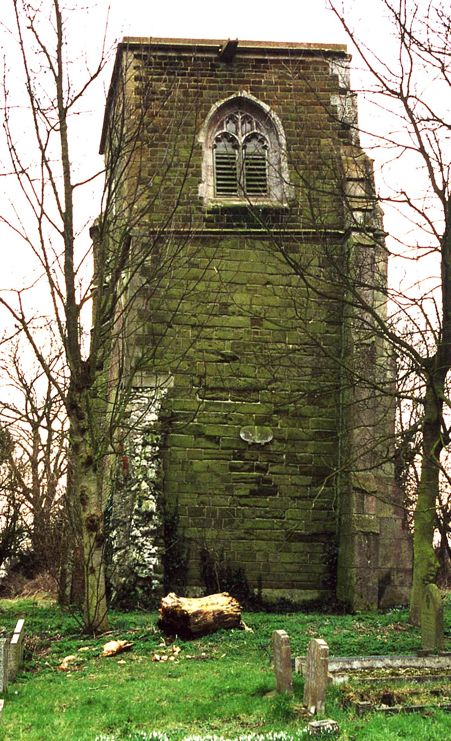
- There was an earlier church here, but it was abandoned in the early 1800s after it started to subside. The tower still stands and was used a mortuary chapel for burials in the old churchyard.
- Chris ? has a photograph of a plaque on the Old Tower on Geo-graph, taken in October, 2012.
- J. HANNAN-BRIGGS also has a photograph of the "Old St. Peter" Tower on Geo-graph, taken in June, 2012. And you can see signs of the subsideance as the tower leans to the right.
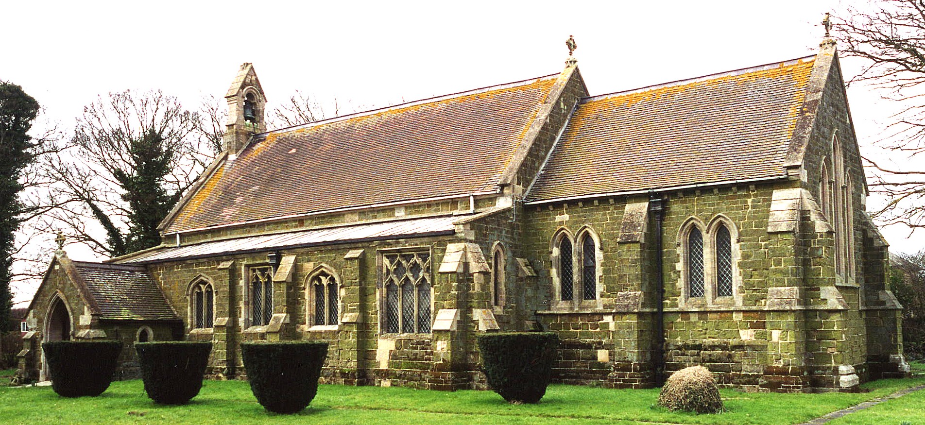
- The church was rebuilt in 1877 on a new site a half mile west, but using a lot of material from the old church.
- The Diocese of Lincoln declared the Old Tower redundant in October, 1972. In 1975 they gifted it to the public as a monument.
- The tower is a Grade I listed building with British Heritage.
- The new church seats 190.
- Richard CROFT has a photograph of Old St. Peter's Church on Geo-graph, taken in April, 2006.
- There is a photograph of St. Peter's Church on the Wendy PARKINSON Church Photos web site.
- Here is a photo of old St. Peter's Church, taken by Ron COLE (who retains the copyright):
- And here is a photo of the new St. Peter's Church, taken by Ron Cole (who retains the copyright):
- The Anglican parish register dates from 1607, but many pages are missing until 1653.
- The Lincolnshire FHS has published several Marriage indexes and a Burial index for the Louthesk Deanery to make your search easier.
- The Wesleyan Methodists built a chapel here in 1848 and the Primitive Methodists built one in 1847, which they replaced in 1907.
- For information and assistance in researching these chapels, see our non-conformist religions page.
- Check our Church Records page for county-wide resources.
- The parish was in the Saltfleet sub-district of the Louth Registration District.
- Check our Civil Registration page for sources and background on Civil Registration which began in July, 1837.
Saltfleetby St. Peter is a village and parish near the North Sea, 142 miles north of London by rail, 8 miles east-by-north from Louth, and about 10 miles north of Alford. The Long Eau River (or Drain) passes along the southern edge of the parish. The parish covers just over 2,200 acres.
If you are planning a visit:
- By automobile, take the A1031 trunk road (runs up the coast near the North Sea, and turn west onto the B1200. The village is about two miles west of the intersection of the two roads.
- There is bus passenger service to the area. J. THOMAS has a photograph of a Bus Shelter on Geo-graph, taken in March, 2015.
- See our touring page for visitor services.
- Ask for a calculation of the distance from Saltfleetby St Peter to another place.
In 1896, Major Richard Francis CHAPLIN of Louth was one of the principal landowners in the parish.
- See our Maps page for additional resources.
You can see maps centred on OS grid reference TF437897 (Lat/Lon: 53.384864, 0.159817), Saltfleetby St Peter which are provided by:
- OpenStreetMap
- Google Maps
- StreetMap (Current Ordnance Survey maps)
- Bing (was Multimap)
- Old Maps Online
- National Library of Scotland (Old Ordnance Survey maps)
- Vision of Britain (Click "Historical units & statistics" for administrative areas.)
- English Jurisdictions in 1851 (Unfortunately the LDS have removed the facility to enable us to specify a starting location, you will need to search yourself on their map.)
- Magic (Geographic information) (Click + on map if it doesn't show)
- GeoHack (Links to on-line maps and location specific services.)
- All places within the same township/parish shown on an Openstreetmap map.
- Nearby townships/parishes shown on an Openstreetmap map.
- Nearby places shown on an Openstreetmap map.
- "Saltfleetby St. Peter" is also called "West Saltfleetby".
- Locals refer to the three Saltfleetbys as "Soloby".
- This place was an ancient parish in Lincolnshire and became a modern Civil Parish when those were established.
- The parish was in the ancient Louth Eske Wapentake in the East Lindsey district in the parts of Lindsey.
- The parish boundaries were changed in 1887 with some parts given to Saltfleetby All Saints and Saltfleetby St. Clements.
- For today's district governance, see the East Lindsey District Council.
- Bastardy cases would be heard in the Louth petty sessional courts.
- After the Poor Law Amendment Act reforms of 1834, this parish became a part of the Louth Poor Law Union.
- A National School for the three Saltfleetby parishes was built here in 1851 and a library added in 1855. The school was enlarged in 1894.
- See our Schools page for more information on researching school records.