
Hide
Saxby
hide
Hide
hide
Hide
hide
Hide
Hide
Hide
- The parish was in the North-East sub-district of the Lincoln Registration District.
- Check our Census Resource page for county-wide resources.
- The table below gives census piece numbers, where known:
| Census Year | Piece No. |
|---|---|
| 1861 | R.G. 9 / 2364 |
| 1871 | R.G. 10 / 3375 & 3377 |
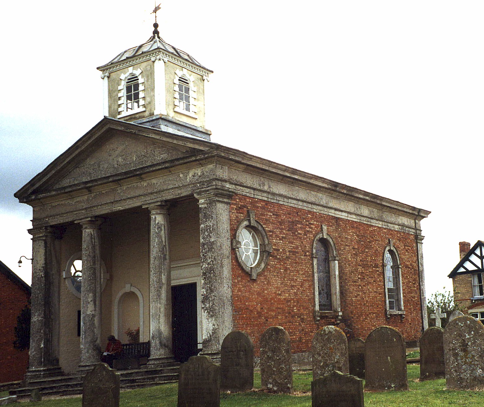
- The Anglican parish church is dedicated to Saint Helen.
- The church was originally built as a mortuary chapel for the SAUNDERSON family in 1775.
- The church was restored in 1869, then again in 1895.
- The church seats only about 70 people.
- The church was restored and redecorated in 1948. It opened for services Sunday, June 13th, 1948.
- We have a list of contributors, which includes many dates of marriage. We have the same data in a Rich Text File if you prefer.
- Julian P. GUFFOGG has a photograph of St. Helen's Church on Geo-graph, taken in May, 2017.
- David HITCHBORNE has a photograph of the other end of St. Helen's Church on Geo-graph, taken in May, 2004.
- Here is a photo of St. Helen's Church, taken by Ron COLE (who retains the copyright):
- The parish church register dates from 1666.
- The Lincolnshire FHS has a Loan Library service which has the parish registers on microfiche for Baptisms from 1666 to 1812 and Marriages from 1555 to 1654.
- The LFHS has published several marriage indexes and a burial index for the Lawres Deanery to make your search easier.
- Check our Church Records page for county-wide resources.
- The parish was in the North-East sub-district of the Lincoln Registration District.
- Check our Civil Registration page for sources and background on Civil Registration which began in July, 1837.
Saxby (Saxby by Owmby) is both a village and a parish north of the city of Lincoln. Owmby parish lies to the north and Spridlington parish to the south. The parish covers about 1,370 acres.
Saxby village is just about a mile east of the Roman Road known as Ermine Street. If you are planning a visit:
- Take the A15 north out of Lincoln for about seven miles. About a mile before you get to the to the A631, turn right to Saxby.
- See our touring page for more sources.
- Ask for a calculation of the distance from Saxby to another place.
- See our Maps page for additional resources.
You can see maps centred on OS grid reference TF005862 (Lat/Lon: 53.363563, -0.491638), Saxby which are provided by:
- OpenStreetMap
- Google Maps
- StreetMap (Current Ordnance Survey maps)
- Bing (was Multimap)
- Old Maps Online
- National Library of Scotland (Old Ordnance Survey maps)
- Vision of Britain (Click "Historical units & statistics" for administrative areas.)
- English Jurisdictions in 1851 (Unfortunately the LDS have removed the facility to enable us to specify a starting location, you will need to search yourself on their map.)
- Magic (Geographic information) (Click + on map if it doesn't show)
- GeoHack (Links to on-line maps and location specific services.)
- All places within the same township/parish shown on an Openstreetmap map.
- Nearby townships/parishes shown on an Openstreetmap map.
- Nearby places shown on an Openstreetmap map.
Neil THEASBY has a photograph of Leading Aircraftman Derrick Hugh MATTHEWS on Geo-graph, taken in April, 2015. MATTHEWS died on May 25th 1946 aged 22.
Derrick Hugh MATTHEWS is the only Commonwealth War Grave in Saxby St. Helen's churchyard. He was the husband of Joan Hazel MATTHEWS.
- This place was an ancient parish in Lincoln county and became a modern Civil Parish when those were established.
- The parish was in the eastern division of the ancient Aslacoe Wapentake in the West Lindsey district in the parts of Lindsey.
- The parish is also in the Soke of Kirton-in-Lindsey.
- Today's district governance is provided by the West Lindsey District Council.
- Bastardy cases would be heard in the Lincoln (Bail and Close) petty session hearings.
- As a result of the Poor Law Amendment Act of 1834, the parish became part of the Lincoln Poor Law Union.
- Children of this parish attended schools at Spridlington and Normanby-by-Spital.
- For more on researching school records, see our Schools Research page.