
Hide
South Ormsby
hide
Hide
hide
Hide
hide
Hide
Hide
hide
Hide
Hide
The Community Library at Alford has a local history archive that will prove useful in your research.
Ron COLES photograph under Church History shows a good portion of the churchyard graves.
Jonathan THACKER has a photograph of the Tomb of Richard Ayscoghe Martin Floyer on Geo-graph, taken in September, 2020.
- The parish was in the Alford sub-district of the Spilsby Registration District.
- Check our Census Resource page for county-wide resources.
- The table below gives census piece numbers, where known:
Census
YearPiece No. 1841 H.O. 107 / 641 1851 H.O. 107 / 2110 1861 R.G. 9 / 2377 1871 R.G. 10 / 3395 1891 R.G. 12 / 2605
- The parish once had a church dedicated to Saint Margaret in the hamlet of Ketsby.
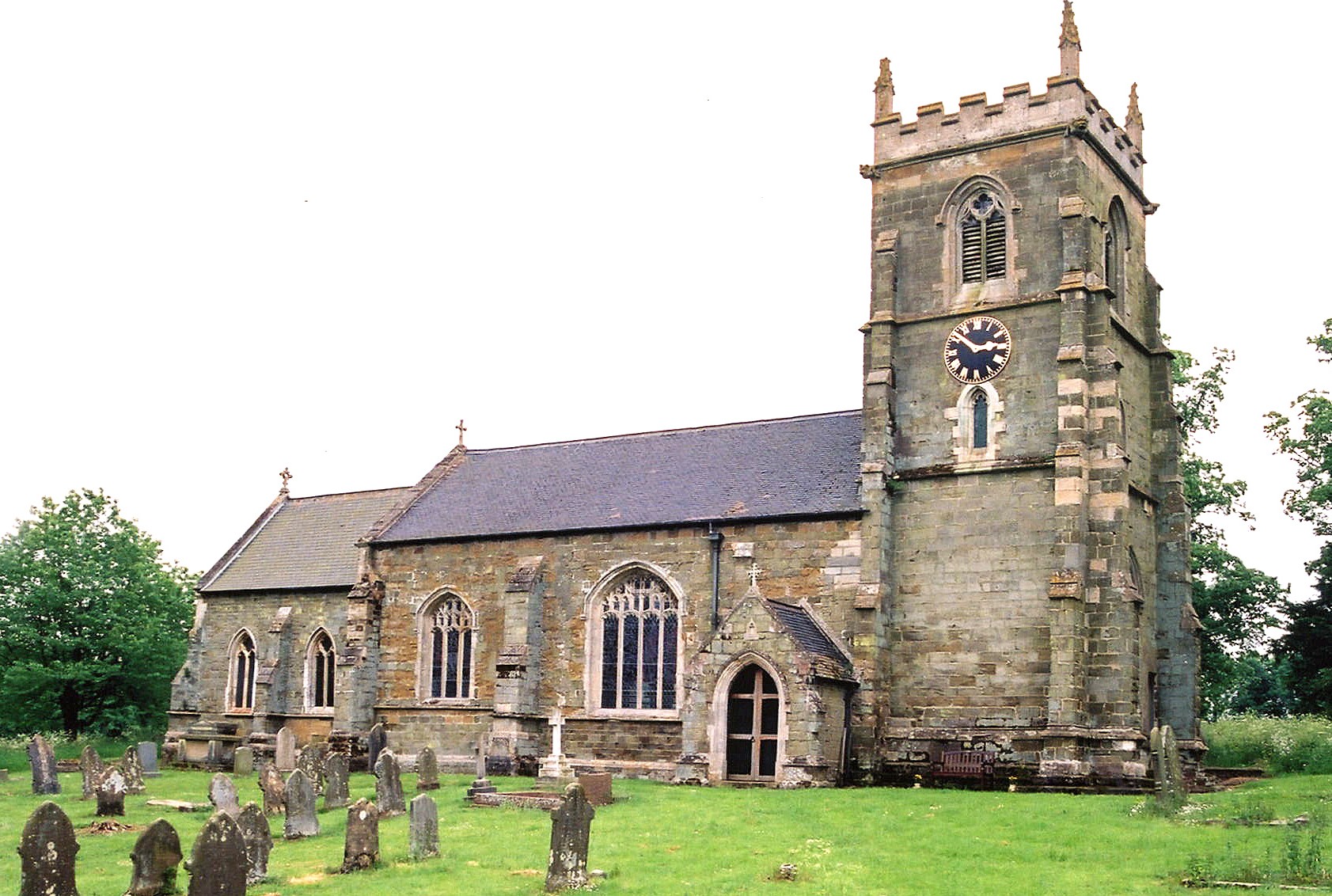
- The Anglican parish church is dedicated to Saint Leonard.
- The church is built of sandstone.
- The church was restored and re-roofed in 1871.
- The church seats 300.
- There is a photograph of St. Leonard's Church on the Wendy PARKINSON Church Photos web site.
- Richard CROFT has a photograph of St. Leonard's Church on Geo-graph, taken in January, 2006.
- Here is a photo of St. Leonard's taken by Ron COLE (who retains the copyright):
- The Anglican parish register dates from 1561.
- We have a list of Rectors for 1600 - 1799 which you might find useful.
- The Lincolnshire FHS has published several marriage indexes and a burial index for the Bolingbroke Deanery to make your search easier.
- Check our Church Records page for county-wide resources.
- The parish was in the Alford sub-district of the Spilsby Registration District.
- Check our Civil Registration page for sources and background on Civil Registration which began in July, 1837.
This village and parish lie 6 miles west of Alford. Brinkhill parish lies to the south and Calceby parish to the west. The parish covers just under 2,500 acres and includes the hamlet of Ketsby.
If you are planning a visit:
- See the Lincolnshire Touring and Holidays page on this site.
- Ask for a calculation of the distance from South Ormsby to another place.
- East of the village there are the remains of a Roman encampment.
- The Domesday Book mentions a water mill in the parish.
- John HOPE has a photograph of the Massingberd Arms P. H. on Geo-graph, taken in June, 2004.
- Richard GREEN alo has a photograph of the Masssingberd Arms on Geo-graph, taken in May, 2004.
- The Massingberd Arms Public House was (and still is) a popular spot for swapping local news. Here are the proprietors shown in various Directories:
Year Person 1842 Geo. ENDERBY, vict. 1868 Absalom COOK 1872 -- not listed -- 1882 -- not listed -- 1896 William TASKER, farmer 1900 William TASKER 1913 Jas. G. NORTH 1930 George William CALVERT
- Ormsby Hall is a spacious brick mansion in 120 acre wooded park.
- J. THOMAS has a photograph of Ormsby Hall on Geo-graph, taken in June, 2020.
- Ketsby Hall was occupied by a farmer in 1912.
- See our Maps page for additional resources.
You can see maps centred on OS grid reference TF369751 (Lat/Lon: 53.255254, 0.05065), South Ormsby which are provided by:
- OpenStreetMap
- Google Maps
- StreetMap (Current Ordnance Survey maps)
- Bing (was Multimap)
- Old Maps Online
- National Library of Scotland (Old Ordnance Survey maps)
- Vision of Britain (Click "Historical units & statistics" for administrative areas.)
- English Jurisdictions in 1851 (Unfortunately the LDS have removed the facility to enable us to specify a starting location, you will need to search yourself on their map.)
- Magic (Geographic information) (Click + on map if it doesn't show)
- GeoHack (Links to on-line maps and location specific services.)
- All places within the same township/parish shown on an Openstreetmap map.
- Nearby townships/parishes shown on an Openstreetmap map.
- Nearby places shown on an Openstreetmap map.
- In 1896 a Col. Lawrence HEYWORTH is listed as residing at Ormsby Hall. He is listed there with his family in the 1891 census.
- In 1903, Lieut. G. B. MASSINGBERD-MUNDY, Instructor of Musketry (appointed in 1901) for the 4th Battalion, the Lincolnshire Regt., was promoted to Captain. He was a resident of South Ormsby in 1930.
- This place became a modern Civil Parish in December, 1774.
- The parish was in the ancient Hill Wapentake (or Hill Hundred) in the East Lindsey district in the parts of Lindsey.
- For today's governance, see the East Lindsey District Council.
- Kelly's 1900 Directory of Lincolnshire reports the parish as being in the South Lindsey district in the parts of Lindsey. The 1913 version does the same.
- Bastardy cases would be heard in the Alford petty sessional hearings.
- As a result of the 1834 Poor Law Amendment Act, the parish became part of the Spilsby Poor Law Union.
- A Public Elementary School was built here in 1858 to hold 85 children.
- Jonathan THACKER has a photograph of the School House and former school on Geo-graph, taken in September, 2020.
- See our Schools page for more information on researching school records.