
Hide
South Witham
hide
Hide
hide
Hide
hide
Hide
Hide
Hide
The Library at Grantham will prove useful in your research.
- The parish has a public cemetery on the northeast side of the village. The webpage author has been unable to find out details on this cemetery.
- The parish was in the Colsterworth sub-district of the Grantham Registration District.
- In 1891, the parish was in the new "Grantham South" sub-district of the Grantham Registration District.
- Check our Census Resource page for county-wide resources.
- The table below gives census piece numbers, where known:
Census
YearPiece No. 1841 H.O. 107 / 624 1861 R.G. 9 / 2347 1871 R.G. 10 / 3355 1891 R.G. 12 / 2582
| Mill Lane/Thistleton Lane, South Witham, Congregationalist |
- The Knights Templar founded a preceptory here in 1164 on what is now known as Temple Hill. The Knights were disbanded in 1312. Archaeologists still visit the site.
- Tim Heaton has a photograph of Templar Hill on Geo-graph, taken in May, 2006. It is unclear why this area is called a "hill".
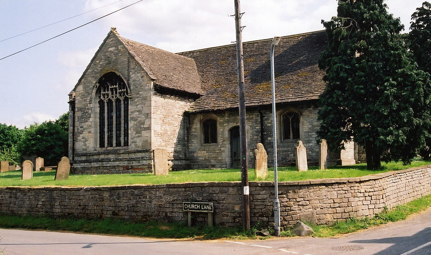
- The Anglican parish church is dedicated to Saint John the Baptist.
- The church was originally built in a cruciform layout, but parts were allowed to go to ruin and were removed.
- The church was restored in 1900.
- The church seats 250.
- Tim HEATON has a photograph of St. John's Church on Geo-graph, taken in December, 2005.
- Here is a photo of St. John's Church, taken by Ron COLE (who retains the copyright):
- The Anglican parish registers exist from 1686.
- The Anglican churchyard was closed to further burials in April, 1893.
- Boyd's marriage index covers the period from 1688 - 1837.
- The LDS Church's Family History Library has a printout of baptisms from 1813-1851.
- We have a handful of entries from the Parish register in a text file. Your additions and corrections are welcomed.
- The Lincolnshire FHS has published several marriage and burial indexes for the Beltisloe Deanery to make your search easier.
- The Wesleyan Methodists and Congregationalists each built a chapel in the parish before 1896.
- For information and assistance in researching these chapels, see our non-conformist religions page.
- Check our Church Records page for county-wide resources.
- The parish was in the Colsterworth sub-district of the Grantham Registration District.
- In 1891, the parish was in the new "Grantham South" sub-district of the Grantham Registration District.
- Check our Civil Registration page for sources and background on Civil Registration which began in July, 1837.
South Witham is both a village and parish on the River Witham 11 miles south of Grantham, less than a mile off the A1 trunk road to the west. The river flows north at this point, toward neighboring North Witham parish. The parish is bordered by Leicester and Rutland counties on the west and south. The parish covers about 1,770 acres and includes the Forty Acre Wood.
If you are planning a visit:
- "Ermine Street," the old Roman "North Road" to Lincoln, crosses this parish.
- There used to be train service to Bourne and Spalding in the later half of the 1800s and the early 1900s. That service ceased around 1960.
- Marathon has a photograph of the Village Sign on Geo-graph, taken in July, 2012. The village does have a prettier sign as seen on the village website (below).
- You can visit the village website to familiarize youself with the place.
- Markery Wood has a car park near the village. The wood is part of the Kesteven Forest.
- See our touring page for visitor services.
- Ask for a calculation of the distance from South Witham to another place.
- In 1842, there are three Pubs in the village; the Angel, The Blue Bell and the Blue Cow.
- Tim HEATON has a photograph of the Angel Inn on Geo-graph, taken in December, 2005.
- These are the names associated with the Angel Inn in various directories:
Year Person 1842 Naaman BEESON, vict. & bricklayer 1868 Naaman BEESON, builder 1872 Naaman BEESON, vict. & stonemason 1882 George Kelley HUDSON, vict., farmer & blacksmith 1896 George Kelly HUDSON, farmer & blacksmith 1900 George Kelly HUDSON, farmer & blacksmith 1913 Robert CORNER 1930 Robert CORNER
There was a Fox Inn on the Common in 1882. It may have replaced the Blue Bell. The Fox is not listed in 1900.
- See our Maps page for additional resources.
You can see maps centred on OS grid reference SK926192 (Lat/Lon: 52.762476, -0.629148), South Witham which are provided by:
- OpenStreetMap
- Google Maps
- StreetMap (Current Ordnance Survey maps)
- Bing (was Multimap)
- Old Maps Online
- National Library of Scotland (Old Ordnance Survey maps)
- Vision of Britain (Click "Historical units & statistics" for administrative areas.)
- English Jurisdictions in 1851 (Unfortunately the LDS have removed the facility to enable us to specify a starting location, you will need to search yourself on their map.)
- Magic (Geographic information) (Click + on map if it doesn't show)
- GeoHack (Links to on-line maps and location specific services.)
- All places within the same township/parish shown on an Openstreetmap map.
- Nearby townships/parishes shown on an Openstreetmap map.
- Nearby places shown on an Openstreetmap map.
- Alan MURRAY-RUST has a photograph of the War Memorial in the churchyard on Geo-graph, taken in March, 2020.
- In 2015, the Parish Council announced that a grant of £2,490 was available to repair and restore the memorial cross.
- Worried about a German invasion, The MOD erected a number of pillboxes to defend important roads and waterways. Gary RADFORD has a photograph of a Pillbox near Temple Hill on Geo-graph, taken in April, 2007.
- During World War II, the RAF maintained a storage depot in Morkery Wood for bombs, ammunition and oxygen tanks for aircraft. The unit was designated as RAF South Witham.
- In 1966, the RAF built a large housing estate here for the servicemen stationed at RAF Cottesmore. The village population trebled in size and the school had to be enlarged as well.
- On August 2nd, 1973, a Canberra bomber crashed in a field east of "The Fox" pub (the crash site is actually in North Witham).
There are two Commonwealth War Graves in St. John's churchyard, one from each World War:
- Edward BEAN, corp., Lincs Regt., age 32, died 8 Nov. 1918. Husband of H. Bean of South Witham.
- Norman W. WING, gunner, 2nd Searchlight Regt. of Royal Artillery, age 21, died 15 Oct. 1943. Son of Robert Henry and Hilda Wing of South Witham.
The following names (all WWI) are noted on the War Memorial's base:
- ASH, Wilfred
- BEAN, Edward, Labour Corps
- FORD, William, 2nd Lincs Regt., son of Joseph and Bertha FORD
- GLENN, George Edward
- MARRIOTT, Frank William, 9th Btln Leics. Regt., husband of Gertrude Eliza FISH (formerly MARRIOTT) of Melton Mowbray, LEI
- PARKINSON, Robert Henry, probably: born 1898, So. Witham, son of John T. and Eliza PARKINSON
- SMITH, William
- STEANS, Alfred Wilford, probably: 9 Btln Leics Regt.
- WILLET, Gerald Percy (WILLETT on CWWG database), 8th Btln Leics Regt., son of William and Hannah WILLETT of Rutland
- Witham is from the Celtic or pre-Celtic river name of uncertain origin, and the name appeared as Widme in the 1086 Domesday Book.
[A. D. Mills, "A Dictionary of English Place-Names," Oxford University Press, 1991]
- The village name has also often appeared spelled as South Wytham
- This place was an ancient parish in Lincoln county and it became a modern Civil Parish when those were established.
- The parish was in the ancient Beltisloe Wapentake in the South Kesteven district and parts of Kesteven.
- You can contact the Parish Council regarding civic or political matters, but they are NOT staffed to assist with family history searches.
- For today's district governance, contact the South Kesteven District Council.
- Bastardy cases would be heard in the Spittlegate (Grantham) petty session hearings.
- The Common Lands were enclosed here in 1796.
- There was a charity of £30 left by Richard HALFORD. The interest from this was distributed on St. Thomas day to poor parishoners who had been attending church services.
- As a result of the Poor Law Amendment Act reforms of 1834, the parish became part of the Grantham Poor Law Union.
Year Inhabitants 1801 343 1831 410 1841 506 1851 544 1861 531 1871 488 1881 410 1891 575 1911 410 1921 446 1931 427
- The parish established a School Board in January, 1877.
- A Board School (Public Elementary School) was erected in 1879, funded primarily by Ralph TOLLEMACHE, and enlarged in 1899. The facility is on Water Lane and the school is now known as the South Witham Community Primary School.
- For more on researching school records, see our Schools Research page.