
Hide
Spanby
hide
Hide
hide
Hide
hide
Hide
Hide
hide
Hide
Hide
- The parish was in the Aswarby sub-district of the Sleaford Registration District.
- In an 1890 re-organization, the parish was re-assigned to the Leadenham sub-district.
- Check our Census Resource page for county-wide resources.
- The table below gives census piece numbers, where known:
| Census Year | Piece No. |
|---|---|
| 1841 | H.O. 107 / 622 |
| 1861 | R.G. 9 / 2346 |
| 1871 | R.G. 10 / 3353 |
| 1891 | R.G. 12 / 2581 |
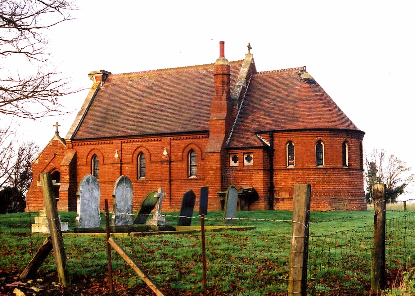
- The Anglican parish church is dedicated to Saint Nicholas.
- The church was rebuilt in 1880 after the old one was torn down. This is at least the third church built on this site.
- The church is a small red brick building with red Ancaster stone dressings.
- The church seats about 65 people.
- The Diocese of Lincoln declared this church redundant in October, 1973. In May of 1977 it was sold and converted into a garden store.
- The church is a Grade II listed building with English Heritage.
- Here is a photo of St. Nicholas Church, taken by Ron COLE (who retains the copyright):
- The Anglican parish register dates from 1681.
- The LFHS has published several marriage and burial indexes for the Lafford Deanery to make your search easier.
- Kelly's 1900 Directory of Lincolnshire places the parish in the rural Deanery of Aveland, as does the 1913 edition.
- The Lincolnshire FHS has a Loan Library service which has the parish registers on microfiche for Baptisms from 1681 to 1812 and Marriages from 1658 to 1758.
- 400 burials can be found on the NBI for St. Nicholas church covering 1817 thru 1900 (with gaps).
- Check our Church Records page for county-wide resources.
- The parish was in the Aswarby sub-district of the Sleaford Registration District.
- In 1891, the parish was transferred to the Leadenham sub-district.
- Check our Civil Registration page for sources and background on Civil Registration which started in July, 1837.
Spanby is both a village and parish 6 miles due south of Sleaford. Swaton parish lies to the east and Scredington parish to the north. The parish covers just over 1,000 acres.
There isn't much left of the village of Spanby. If you are planning a visit:
- By automobile, take the A52 trunk road between Grantham and Boston, and turn north at Threkingham.
- See our touring page for more sources.
- Ask for a calculation of the distance from Spanby to another place.
- See our "Maps" page for additional resources.
You can see maps centred on OS grid reference TF095381 (Lat/Lon: 52.929551, -0.371819), Spanby which are provided by:
- OpenStreetMap
- Google Maps
- StreetMap (Current Ordnance Survey maps)
- Bing (was Multimap)
- Old Maps Online
- National Library of Scotland (Old Ordnance Survey maps)
- Vision of Britain (Click "Historical units & statistics" for administrative areas.)
- English Jurisdictions in 1851 (Unfortunately the LDS have removed the facility to enable us to specify a starting location, you will need to search yourself on their map.)
- Magic (Geographic information) (Click + on map if it doesn't show)
- GeoHack (Links to on-line maps and location specific services.)
- All places within the same township/parish shown on an Openstreetmap map.
- Nearby townships/parishes shown on an Openstreetmap map.
- Nearby places shown on an Openstreetmap map.
- This place was an ancient Chapelry in Lincolnshire. It became a separate, modern Civil Parish some time in the early 1800s.
- The parish was in the ancient Flaxwell Wapentake in the North Kesteven division of the county, parts of Kesteven.
- Before 1840, the parish was part of the Aveland Wapentake. Kelly's 1900 Directory of Lincolnshire also places the parish in the Aveland Wapentake, as does the 1913 edition.
- In April, 1931, the civil parish was abolished to enlarge Threckingham parish.
- For today's district governance, see the North Kesteven District Council.
- Bastardy cases would be heard in the Sleaford petty session hearings every Monday.
- Land for the poor was enclosed around 1805.
- After the Poor Law Amendment Act reforms of 1834, the parish became part of the Sleaford Poor Law Union.
- The children of this parish attended school in Osbournby parrish.
- For more on researching school records, see our Schools Research page.