
Hide
Stoke Rochford
hide
Hide
hide
Hide
hide
Hide
Hide
hide
Hide
Hide
The Library at Grantham will prove useful in your research.
Timothy HEATON has a photograph of the Churchyard of St. Andrew and St. Mary on Geo-graph, taken in August, 2017.
Andrew TATLOW has a photograph of the McCorquodale gravestones on Geo-graph, taken in October, 2013. These are relatives of Princess Diana.
- The parish was in the Denton sub-district of the Grantham Registration District.
- In 1891, the district was "re-organized" and the parish assigned to the Grantham South subdistrict of the Grantham Registration District.
- Check our Census Resource page for county-wide resources.
- The table below gives census piece numbers, where known:
| Census Year | Piece No. |
|---|---|
| 1841 | H.O. 107 / 618 |
| 1851 | H.O. 107 / 2102 |
| 1861 | R.G. 9 / 2348 |
| 1871 | R.G. 10 / 3357 |
| 1891 | R.G. 12 / 2582 |
- There was formerly a church dedicated to Saint Andrew in North Stoke, but that church was demolished some years prior to 1913.
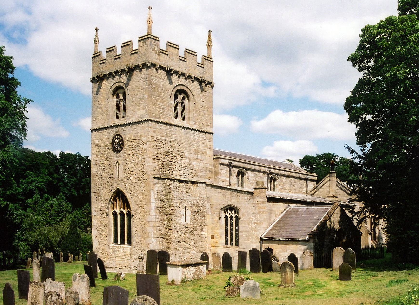
- The Anglican parish church is dedicated to Saint Mary and Saint Andrew.
- The church appears in Simon JENKINS' book, "England's Thousand Best Churches", published by Penguin.
- The church seats 250.
- Interior church photographs on The Rochfords site.
- Here is a photo of St. Mary and St. Andrew Church, taken by Ron COLE (who retains the copyright):
- We have a small number of parish register entries extracted into a text file. Your additions are welcome.
- The LFHS has published several marriage and burial indexes for the Beltisloe Deanery to make your search easier. In the early 1900's, the parish was in the South Grantham Deanery.
- Check our Church Records page for county-wide resources.
- The parish was in the Denton sub-district of the Grantham Registration District.
- In 1891, the district was "re-organized" and the parish assigned to the Grantham South subdistrict of the Grantham Registration District.
- Check our Civil Registration page for sources and background on Civil Registration which began in July, 1837.
Stoke Rochford is both a village and a parish, although the parish is sometimes refered to as North Stoke and South Stoke. The parish itself is bounded on the north by Great Ponton, on the south by Skillington parish and Easton township.
Cringle Brook rises near the village of Stoke and feeds northward into the River Witham. If you are planning a visit:
- By automobile, take the A1 Motorway south out of Grantham for six miles, past Great Ponton. Stoke Rochford will be on the right, and the township of Easton on the left.
- Visitors may want to see the Easton Walled Gardens. Until World War II this place had been gardened continuously for at least 400 years.
- Andrew TATLOW has a photograph of the Village Sign on Geo-graph, taken in October, 2013.
- See our touring page for more sources.
- Ask for a calculation of the distance from Stoke Rochford to another place.
- The Romans had a settlement here, but it was apparently not fortified.
- Adrian S. PYE has a photograph of the old Village Pump on Geo-graph, taken in June, 2020. The cap[tion gives details.
- William the Conqueror granted this parish to the ROCHFORD family, but by 1663 it had passed to the TURNORs.
- Jonathan THACKER has a photograph of the Wayside Cross at Easton on Geo-graph, taken in October, 2019.
- Stoke Park manor was originally built around 1764 by Edmund TURNOR. A new mansion was built to replace the old manor house around 1842. The "park", itself, occupied about 400 acres. The Hall was severly damaged by fire in 2005 and has been restored.
- In front of the manor was an obelisk with the inscription "In honour of Sir Isaac Newton." Jonathan THACKER has a photograph of the Newton Obelisk on Geo-graph, taken in October, 2020.
- Trevor RICKARD has a photograph of Stoke Rochford Hall on Geo-graph, taken in July, 2012.
- Patrick MACKIE also has a photograph of Stoke Rochford Hall on Geo-graph, taken in October, 2004.
- Jonathan THACKER also has a photograph of the front of stoke Rochford Hall on Geo-graph, taken in October, 2020. It looks like they grow chimneys there.
- Easton Hall was rebuilt in 1805 and its grounds include a portion of the River Witham.
- Stoke Rochford Hall is now a hotel and conference center.
- There is a photograph of Easton Hall on Geo-graph, taken in March, 2014.
- See our Maps page for additional resources.
You can see maps centred on OS grid reference SK914282 (Lat/Lon: 52.843683, -0.644588), Stoke Rochford which are provided by:
- OpenStreetMap
- Google Maps
- StreetMap (Current Ordnance Survey maps)
- Bing (was Multimap)
- Old Maps Online
- National Library of Scotland (Old Ordnance Survey maps)
- Vision of Britain (Click "Historical units & statistics" for administrative areas.)
- English Jurisdictions in 1851 (Unfortunately the LDS have removed the facility to enable us to specify a starting location, you will need to search yourself on their map.)
- Magic (Geographic information) (Click + on map if it doesn't show)
- GeoHack (Links to on-line maps and location specific services.)
- All places within the same township/parish shown on an Openstreetmap map.
- Nearby townships/parishes shown on an Openstreetmap map.
- Nearby places shown on an Openstreetmap map.
Adrian S. PYE has a photograph of the WWI memorial to Christopher Randolph TURNOR on Geo-graph, taken in June, 2020.
Adrian S. PYE has a photograph of the Lancaster crew memorial on Geo-graph, taken in June, 2020.
In 1946 the Bishop of Grantham attended the dedication of a War Memorial plaque placed inside the parish church. It had the names of three men killed during the World War II.
The names on the WWII memorial are:
- Gooderham, Jack Allan (in CWGC database as "Allan Jack"), 1st bn. Suffolk Regt.
- Parkin, Charles Reginald, 2nd bn. Royal Inniskilling fusiliers
- Tanner, Hubert C C, lt., HMS Grafton
- The parish consisted of three townships: North Stoke, South Stoke and Easton.
- The parish was in the ancient Winnibrigs and Threo Wapentake in the South Kesteven district in the parts of Kesteven.
- The parish was also within the Soke of Grantham.
- Timothy HEATON has a photograph of the Village Hall on Geo-graph, taken in August, 2017.
- For today's district governance, contact the South Kesteven District Council.
- Bastardy cases would be heard in the Spittlegate (Grantham) petty session hearings.
- In 1677, Sir Edmund TURNOR endowed six almshouses for the poor of North and South Stoke.
- The Reverend William DODWELL left the dividends of £1,608 to care for the parish poor.
- In 1785, the Reverend J. HARRISONS left the interest of £100 to care for the parish poor.
- The Common Lands were enclosed here in 1800.
- As a result of the Poor Law Amendment Act reforms of 1834, the parish became part of the Grantham Poor Law Union.
- The parish school was first built here in 1840.
- Jonathan THACKER has a photograph of the Old school on Geo-graph, taken in October, 2020.
- A school was built in Easton township in 1878 to hold 45 children.
- For more on researching school records, see our Schools Research page.