
Hide
Surfleet
hide
Hide
hide
Hide
hide
Hide
Hide
hide
Hide
Hide
- Many parish records can be found at the Spalding Library.
- The parish was in the Gosberton sub-district of the Spalding Registration District.
- We have the complete 1891 Census for Gosberton and Surfleet (some Enum. Districts overlap).
- We have a partial surname index for the 1901 Census. Your additions are welcome.
- Check our Census Resource page for county-wide resources.
- The table below gives census piece numbers, where known:
| Census Year | Piece No. |
|---|---|
| 1841 | H.O. 107 / 611 |
| 1851 | H.O. 107 / 2096 |
| 1861 | R.G. 9 / 2322 |
| 1871 | R.G. 10 / 3320 |
| 1891 | R.G. 12 / 2561 |
| 1901 | R.G. 13 / 3030 |
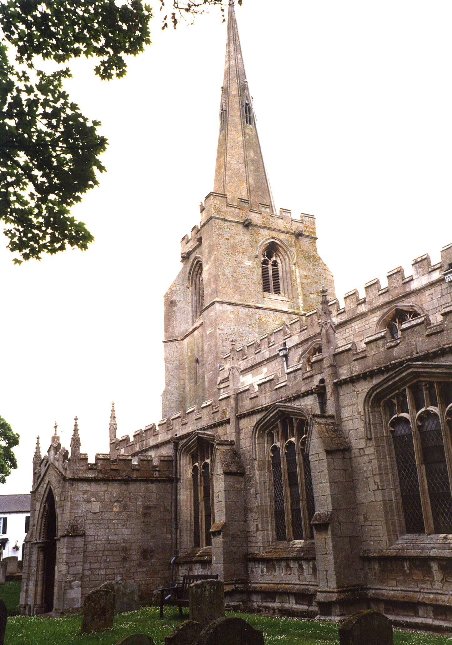
- The Anglican parish church was dedicated to St. Lawrence (also commonly found as "St. Laurance").
- The church includes some Norman work.
- The church was restored between 1900 and 1908.
- The church seats 276.
- Yes, the church tower is "The Leaning Towe of Laurance". The spire is about six feet out of alignment due to subsidence.
- There is a photograph of St. Lawrence's Church on the Wendy PARKINSON Church Photos web site.
- Another photo of the parish church can be found at Currant Bun site listed on our Church Photographs page.
- Here is a photo of Saint Laurance's Church, taken by Ron COLE (who retains the copyright):
- Anglican parish registers exist from 1562 (some sources give 1662).
- The LFHS has published several marriage and burial indexes for the West Elloe Deanery.
- The Wesleyan Methodists and Free Methodists had chapels in Surfleet.
- There is a Wesleyan Chapel at Seas-end.
- For information and assistance in researching these chapels, see our non-conformist religions page.
- Check our Church Records page for county-wide resources.
- The parish was in the Gosberton sub-district of the Spalding Registration District.
- Check our Civil Registration page for sources and background on Civil Registration which began in July, 1837.
Surfleet is both a village and parish 97 mioles north of London city, four miles north of Spalding and southwest of Boston that includes the hamlet of Surfleet Seas-End. The parish is bounded on the northwest by Gosberton parish and on the south by Pinchbeck parish. The River Welland and the River Glen provide a boundary line on the southwest edge of the parish. The area is just over 4,060 acres of flat fenland, drained by many small canals.
If you are planning a visit:
- The A16 trunk road passes through the parish.
- Ian S. has a photograph of the Village Sign on Geo-graph, taken in August, 2011,
- There are three "traditional" bridges across the River Glen in the village. One carries the B1356 thru the heart of the village.
- The Reedbed there is now a wetland preserve of the National Nature Preserve.
- See our touring page for visitor services.
- Ask for a calculation of the distance from Surfleet to another place.
- Tim HEATON has a photograph of the Riverside Inn (just east of the village) on Geo-graph, taken in September, 2006.
- J. THOMAS has a photograph of The Mermaid Inn on geo-graph, taken in April, 2012. IF you see a Mermaid on exiting the Inn, you might ask someone to take you home.
- Alex McGREGOR has a photograph of the Sufleet Beacon on Geo-graph, taken in September, 2015.
- Cressy Hall, near Risegate Eau is a handsome mansion.
- The Manor House was rebuilt by Sir Henry HERON who died in 1695. It was destroyed by fire in 1792 and again rebuilt.
- The Manor House was burnt down about 1820 and was again rebuilt.
- Cressy Hall lies about 3 miles west of the village.
- See our Maps page for additional resources.
You can see maps centred on OS grid reference TF251282 (Lat/Lon: 52.836373, -0.143938), Surfleet which are provided by:
- OpenStreetMap
- Google Maps
- StreetMap (Current Ordnance Survey maps)
- Bing (was Multimap)
- Old Maps Online
- National Library of Scotland (Old Ordnance Survey maps)
- Vision of Britain (Click "Historical units & statistics" for administrative areas.)
- English Jurisdictions in 1851 (Unfortunately the LDS have removed the facility to enable us to specify a starting location, you will need to search yourself on their map.)
- Magic (Geographic information) (Click + on map if it doesn't show)
- GeoHack (Links to on-line maps and location specific services.)
- All places within the same township/parish shown on an Openstreetmap map.
- Nearby townships/parishes shown on an Openstreetmap map.
- Nearby places shown on an Openstreetmap map.
- The list of military men who died in the World Wars can be found on the Surfleet War Memorial.
- The name Surfleet is from the Old English sur+fleot, or "Sour Stream". In the 1086 Domesday Book, the village is given as Sverefelt and in 1167 as Surfleit.
[A. D. Mills, "A Dictionary of English Place-Names," Oxford University Press, 1991]
- The parish was in the ancient Elloe Wapentake in the South Holland district and parts of Holland.
- Alex McGREGOR has a photograph of Surfleet Village Hall on Geo-graph, taken in September, 2015. Stop in when they are open and ask to see a schedule of forth-coming events.
- For today's district governance, visit the South Holland District Council site.
- Bastardy cases would be heard in the Kirton and Skirbeck petty session hearings.
- The Common Land was inclosed here in 1777, with 27 acres set aside for the poor.
- In 1810, Samuel EISDALE let a charity that provided £9 in 1843 to distribute to the poor as food, clothing and the like.
- As a result of the 1834 Poor Law Amendment Act, the parish became part of the Spalding Poor Law Union.
- The parish also had enough poor land set aside to generate about £100 in 1900 for distribution to the poor.
- The Free school was founded and endowed in 1764 by Lady Ann Fraser. The schoolmaster's income was about 40 pounds a year, for which he taught about 20 free students. This school closed in 1877.
- The Public Elementary School was built in 1878 to hold up to 130 children.
- For more on researching school records, see our Schools Research page.