
Hide
Sutterton
hide
Hide
hide
Hide
hide
Hide
Hide
hide
Hide
Hide
The Library at Boston will prove useful in your research.
- A cemetery was formed in 1878 and placed under the control of a nine-member Burial Board.
- Richard CROFT has a photograph of the Sutterton cemetery on Geo-graph, taken in February, 2008.
- The parish was in the Kirton sub-district of the Boston Registration District.
- Check our Census Resource page for county-wide resources.
- We have a partial extract of the 1891 Census for the parish.
- The table below gives census piece numbers, where known:
| Census Year | Piece No. |
|---|---|
| 1841 | H.O. 107 / 611 |
| 1851 | H.O. 107 / 2098 |
| 1861 | R.G. 9 / 2331 |
| 1871 | R.G. 10 / 3334 |
| 1881 | R.G. 11 / 3213 |
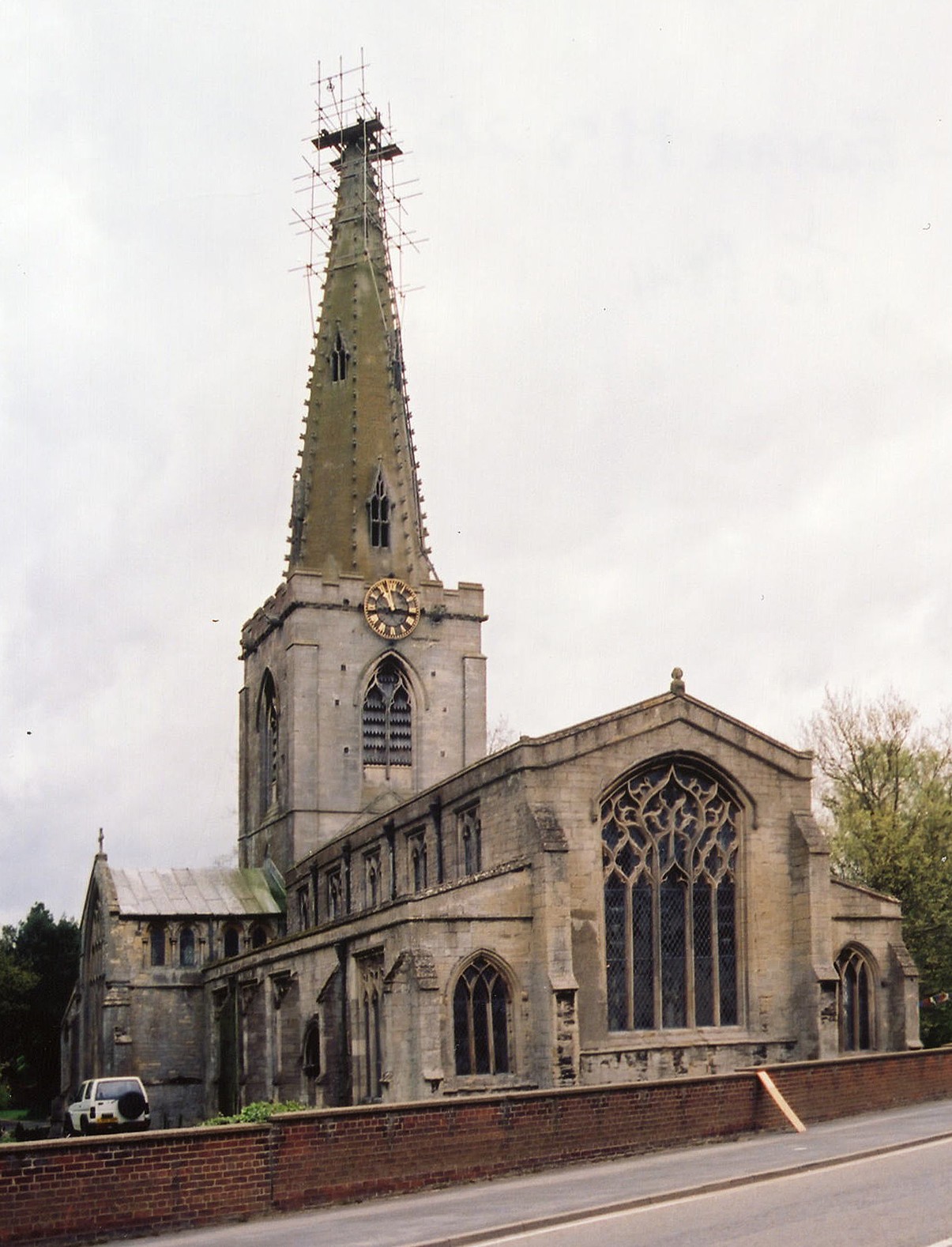
- The Anglican parish church is dedicated to Saint Mary the Blessed Virgin.
- The church was founded in the 11th or 12th century.
- The church tower was rebuilt in 1787 and included a new clock.
- The church itself was thoroughly restored in 1903-8.
- The church seats 450 people.
- Geoff PICK has a photograph of St. Mary's Church on Geo-graph, taken in May, 2004.
- Here is a photo of St. Mary's Church, taken by Ron COLE (who retains the copyright):
- The Anglican parish register dates from 1538 for baptisms and burials, from 1539 for marriages.
- The LFHS has published several indexes for the Holland West Deanery to make your search easier.
- We have a fragmentary parish register extract in a text file. Your additions and corrections are welcome.
- The LDS Family History Library has the Parish Register, baptisms, marriages & burials 1538-1924, on film #0989865.
- The LDS Family History Library has the Bishop's Transcipt, baptisms, marriages & burials 1813-1830, on film #0508052 Item 5.
- The LDS Family History Library has the churchwardens accounts, marriages & burials 1754-1949, on film #0094066.
- The Baptists had a chapel here, built in 1803 and rebuilt in 1826. There was also a Wesleyan Methodist chapel built in 1839 and a United Free Methodist chapel erected in 1854.
- Alex McGREGOR has a photograph of the Methodist Chapel on Geo-graph, taken in September, 2016.
- For information and assistance in researching these chapels, see our non-conformist religions page.
- Check our Church Records page for county-wide resources.
- The parish was in the Kirton sub-district of the Boston Registration District.
- Check our Civil Registration page for sources and background on Civil Registration which started in July, 1837.
Sutterton is both a village and a parish in the south of Lincolnshire, on the old road between Spalding and Boston. The parish is about 6 miles south of Boston and covers about 3,000 acres. Wigtoft parish is to the west, with Algarkirk parish to the east. The parish includes the hamlets of Struggs Hill and Dow Dyke.
If you are planning a visit:
- By automobile, take the A16 trunk road north out of Spalding or south out of Boston. Where the A17 intersects, about 6 miles south of Boston, turn north-east for about 1 mile. The village is bisected by the B1397 secondary road.
- Richard CROFT has a photograph of the Village Sign as you enter Sutterton on Geo-graph, taken in November, 2010.
- Richard HUMPHREY has a photograph of the Water Tower on Geo-graph, taken in January, 2015. The Water Tower is a good landmark while walking about the village.
- Check our Touring page for additional resources.
- Ask for a calculation of the distance from Sutterton to another place.
- J. HANNAN-BRIGGS has a photograph of Sutterton Mill on Geo-graph, taken in November, 2012. The mill was originally built in 1840.
- Richard CROFT has a photograph of the Beridge Arms on Geo-graph, taken in August, 2009.
- J. THOMAS has a photograph of the former Angel Inn on Geo-graph, taken in August, 2020.
- The "Thatch Cottage" is currently the only open Pub in the village.
- J. HANNAN-BRIGGS has a photograph of the Thatched Cottage on Geo-graph, taken in April, 2015.
- See our Maps page for additional resources.
You can see maps centred on OS grid reference TF285355 (Lat/Lon: 52.901586, -0.090991), Sutterton which are provided by:
- OpenStreetMap
- Google Maps
- StreetMap (Current Ordnance Survey maps)
- Bing (was Multimap)
- Old Maps Online
- National Library of Scotland (Old Ordnance Survey maps)
- Vision of Britain (Click "Historical units & statistics" for administrative areas.)
- English Jurisdictions in 1851 (Unfortunately the LDS have removed the facility to enable us to specify a starting location, you will need to search yourself on their map.)
- Magic (Geographic information) (Click + on map if it doesn't show)
- GeoHack (Links to on-line maps and location specific services.)
- All places within the same township/parish shown on an Openstreetmap map.
- Nearby townships/parishes shown on an Openstreetmap map.
- Nearby places shown on an Openstreetmap map.
A trace of World War II remains! Here is a photograph of a 3-Bay Pill Box left over from the conflict.
Richard CROFT also has a photograph of that same Cemetery Pillbox on Geo-graph, taken in February, 2008.
A portion of the Sutterton War Memorial can be seen at the Photo Reflect site.
There are the 32 names from that brass tablet in the church (all deceased according to the Imperial War Museum):
- Allwell, Wm. (probably William Edward ALIWELL, pte. 7th Lincs Regt.)
- Annison, Robert
- Barrett, Edward
- Clarke, George
- Clayton, George
- Coleman, John
- Cooper, George
- Craft, John
- Crunkhorn, Arthur (pte. 2nd Suffolk Regt.)
- Crunkhorn, Fred (pte. 1st Coldstream Guards)
- Ding, Douglas
- Ding, Walter
- Faulkner, Edward
- Fuller, William
- Garwell, James
- Gaunt, Ernest
- Hollinsworth, Frederick
- Hubbert, Richard
- Jacklin, Charles
- Jarvis, George
- Keal, Charles
- Keal, Hugh
- Maidens, Sam (Samuel, born 1894, pte. 2nd Lincs Regt.)
- Maples, Fred
- Meades, George
- Meads, Sam
- Poole, Harold
- Sharp, Henry
- Sherriff, Fred
- Sherriff, John
- Strowlger, Henry (pte. 2nd Lincs Regt.)
- Taylor, George
- This place was an ancient parish in Lincoln county and became a modern Civil Parish when those were established.
- The parish was in the ancient Kirton Wapentake in the Boston Borough in the parts of Holland.
- In 1840, the parish covered 6,550 acres. That was reduced by half by 1900.
- In 1880, the parish gave up almost 3,000 acres to help form the new Amber Hill Civil Parish.
- You can contact the local Parish Council about civic or political issues, but they are NOT staffed to answer family history questions.
- For today's district governance, visit the local Boston Borough Council.
- Bastardy cases would be heard in the Kirton and Skirbeck petty session hearings.
- The Common Lands were enclosed here under the Parishes Inclosure Act of 1772.
- As a result of the 1834 Poor Law Amendment Act reforms, this parish became part of the Boston Poorlaw Union.
- A National School was established here in 1825.
- A Public Elementary School was built here in 1865 and enlarged in 1894 to hold 145 children.
- The new “Four Fields” junior (mixed) school was built in 1978.
- See our Schools page for more information on researching school records.