
Hide
Swinderby
hide
Hide
hide
Hide
hide
Hide
Hide
Hide
The Library at Newark will prove useful in your research.
- J. HANNAN-BRIGGS has a photograph of All Saints Church Lych gate at Geo-graph, taken in February, 2012.
- The parish was in the North Collingham sub-district of the Newark Registration District.
- The Lincolnshire Archives holds a "special" (pre-1841) census for 1791. Note: these early returns typically just show the surname of the family and a count of inhabitants by age bracket.
- Check our Census Resource page for county-wide resources.
- The table below gives census piece numbers, where known:
| Census Year | Piece No. |
|---|---|
| 1841 | H.O. 107 / 622 |
| 1851 | H.O. 107 / 2136 |
| 1861 | R.G. 9 / 2476 |
| 1871 | R.G. 10 / 3539 |
| 1891 | R.G. 12 / 2711 |
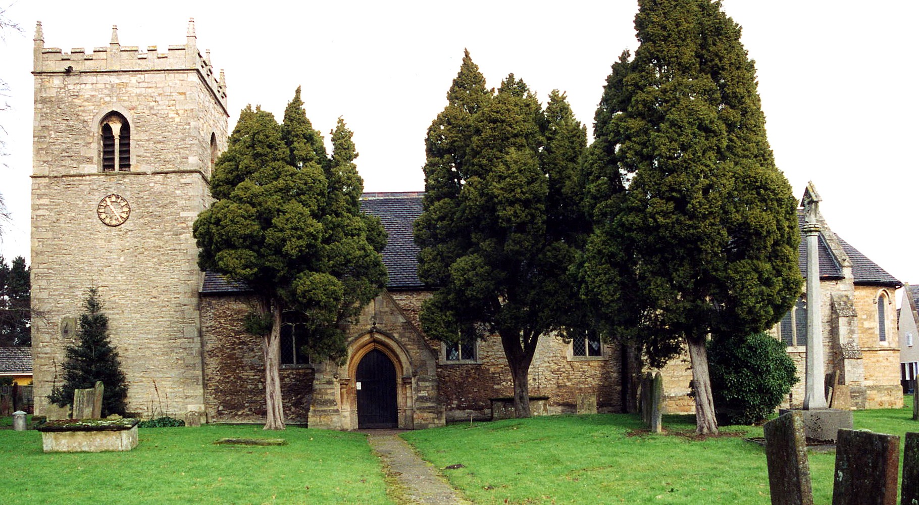
- The Anglican parish church is dedicated to All Saints.
- The church is apparently mostly of Norman architecture. It underwent partial restorations in 1854, 1879 and 1910.
- The clock was installed in the western tower in 1887.
- The church seats 215 people.
- The vicarage for the church is on Station Road.
- There is a photograph of All Saints Church on the Wendy PARKINSON English Church Photo web site.
- There is also a photograph of All Saints Church by Richard CROFT at the Geo-graph web site, taken in October, 2005.
- Here is a photo of All Saints Church, taken by Ron COLE (who retains the copyright):br />
- The parish register dates from 1568, but Bishop's transcripts go back to 1562.
- Parish registers are on file at the Society of Genealogists, covering 1562 - 1812.
- Marriages are in Boyd's Marriage Index, covering 1651 - 1812 and Pallot's Marriage Index, covering 1790 - 1812.
- There is a brass plaque in the church, with inscriptions, dedicated to the DISNEY family, dated 1613.
- J. HANNAN-BRIGGS has a photograph of the DISNEY family brass on Geo-graph, taken in February, 2012.
- The LFHS has published several indexes for the Graffoe Deanery to make your search easier
. - The Wesleyan Methodists built a large chapel here in 1869. For information and assistance in researching these chapels, see our non-conformist religions page.
- Check our Church Records page for county-wide resources.
- The parish was in the North Collingham sub-district of the Newark Registration District.
- Check our Civil Registration page for sources and background on Civil Registration which started in July, 1837.
Swinderby parish is approximately 9 miles SW of Lincoln and 7 miles NE of Newark on Trent. The parish borders on Nottinghamshire to the west, Norton Disney parish to the south and Thurlby (by Lincoln) parish to the east. The ancient Foss Way, now the A46 trunk road, cuts through the southeast corner of the parish. The Trent River is about three miles to the west. The parish covers about 2,200 acres, including the ancient hamlet of Bracken.
The village of Swinderby sits on a rise above the Trent. The parish sports a new hamlet called Witham St. Hugh's. Morton Hall is a hamlet along Morton Road which has grown in the 1900s on the eastern side of Swinderby village. Morton is a separate hamlet a half a mile to the east. If you are planning a visit:
- By automobile, take the A46 southwesterly out of Lincoln.
- There is passenger rail service from Lincoln to the station, which is about a mile north of the village.
- The village hosts an annual antiques and collectors fair, at RAF Swinderby, usually in early June. The fair has been featured on the BBC's Bargain Hunt.
- Caravan and camping sites are available at Oakhill Leisure Park, telephone: 01522 868771.
- There is a nice photograph of part of the village at Pictures of England.
- Check to see what events are happening at the Swinderby Village Hall.
- Visit our touring page for more sources.
- There is a photo of the crossing at South Scarle at Geograph.
- Ask for a calculation of the distance from Swinderby to another place.
- Roman pottery and fragments of the old Roman Foss road have been found in the parish.
- Swinderby was once a station on the Nottingham and Lincoln branch of the Midland railway. The station itself was in Eagle parish to the north.
- In 1871, most of the parish land belonged to either Mrs. MAYOR or the Reverend J. CROMPTON, although there were a number of small lot proprietors.
- Richard CROFT has a photograph of The Plough Pub. on Geo-graph, taken in May, 2006. Reportedly a good place to swap local news.
- See our Maps page for additional resources.
You can see maps centred on OS grid reference SK868630 (Lat/Lon: 53.156653, -0.703468), Swinderby which are provided by:
- OpenStreetMap
- Google Maps
- StreetMap (Current Ordnance Survey maps)
- Bing (was Multimap)
- Old Maps Online
- National Library of Scotland (Old Ordnance Survey maps)
- Vision of Britain (Click "Historical units & statistics" for administrative areas.)
- English Jurisdictions in 1851 (Unfortunately the LDS have removed the facility to enable us to specify a starting location, you will need to search yourself on their map.)
- Magic (Geographic information) (Click + on map if it doesn't show)
- GeoHack (Links to on-line maps and location specific services.)
- All places within the same township/parish shown on an Openstreetmap map.
- Nearby townships/parishes shown on an Openstreetmap map.
- Nearby places shown on an Openstreetmap map.
There were, in effect, two RAF stations in Swinderby parish.
The Airfield:
- The RAF was expanding its facilities just prior to World War II, but RAF Swinderby wasn't yet completed when war broke out. The airfield was just east of the present-day A46 (Fosse Way) road, with the baracks and administrative buildings. The base was allocated to the No. 1 Group of Bomber Command in late August 1940.
- The RAF Swinderby was muddy and waterlogged. A dangerous place for heavy aircraft. Swinderby became a priority site for the installation of hard runways. Construction of these started in late 1941.
- By April 1942, construction was complete, but then the runways had to be lengthened and one crossed Norton Disney Road, which was then closed to traffic.
- On 10 November 1943, a Lancaster III bomber from Swinderby fell from the sky and crashed near Dunholm Lodge killing all on board.
- RAF Swinderby remained in active service after the war, up until March, 1964. Flight operations ceased then, but the facility remained in use as a flying training establishment.
- The RAF closed the airfield in 1994 and it was sold off in 1996. A portion of it is used for the antiques fair, but the technical site was given over to industrial use. But all of the old buildings were demolished in 2003 or 2004. Following that, the site was given over to the "new village" of Witham St. Hugh's.
- The air traffic control tower was taken down in 2010.
- There are a couple of photographs taken at RAF Swinderby and Morton Hall for your enjoyment.
Morton Hall station:
- The headquarters of 5 Group RAF (part of Bomber Command) moved to Morton Hall in the hamlet of Morton near Swinderby village in November, 1943.
- 5 Group RAF disbanded in March, 1955. 5131 Bomb Disposal Squadron stayed on at Morton Hall.
- The RAF closed the base at Morton Hall in 1958.
- The site was converted to a prison for female offenders: HMP Morton Hall, in 1985. In 2011, funding caused the temporary closure of Morton Hall prison and it was converted to an "Immigration Removal Centre."
- The Newark Great War Bulletin for November 1st, 1915 tells us that Private George GILBERT, age 23, of the 1st. Btln. Lincs. Regt. and son of John and Charlotte GILBERT was a prisoner of war in Munster.
- There is an alabaster tablet in the west end of the church dedicated to the men who fell in the Great War.
- There is also a plaque in the IRC Morton Hall from its RAF days, but the web author was unable to find any record of what the plaque commemorates.
- The name Swinderby is Old Scandinavian origin, either from sundri + by, for "southern farmstead or village", or from svin + djur + by, for "farmstead where pigs are kept". In the 1086 Domesday Book it appears as Suindrebi.
[A. D. Mills, "A Dictionary of English Place-Names," Oxford University Press, 1991]
- This place was an ancient parish of Lincolnshire and became a modern Civil Parish when those were established.
- The parish was in the Low division of the ancient Boothby-Graffoe Wapentake in the North Kesteven district in the parts of Kesteven.
- You can contact the local Parish Council concerning civic or political issues, but they are NOT staffed to assist you with family history searches.
- The National Archives holds a copy of the Parish Council minutes, accounts, precepts and notebook from 1894 through 1991 under reference: GB/NNAF/C58282.
- For today's district governance, see the North Kesteven District Council.
- Jonathan BILLINGER has a photograph of the Village Hall on Geo-graph, taken in March, 2011. Stop in when they are open and ask for a copy of the schedule of forth-coming events. You can probably even hire the hall for a family re-union if you'd like.
- Bastardy cases would be heard in the Lincoln South petty session hearings.
- Care of the poor dates back to at least 1658 when John DISNEY, then lord of the manor, donated 20 acres with 13 houses for their use.
- In 1818 five additional houses were raised on the above 20 acres for the use of the poor.
- After the Poor Law Amendment Act reforms of 1834, the parish became part of the Newark Poor Law Union in 1837.
Year Inhabitants 1801 254 1811 307 1841 490 1851 541 1871 548 1881 503 1891 470 1901 423 1911 484 1921 427 1931 361
- The first school was erected here in 1822. In 1849 a new public elementary school was built to replace the older building. The current school is on the High Street and has about 77 students.
- The Kisimul Independent School operates in the parish today at the old vicarage, opened some time prior to 1996. It is a residential special school for children ages 10 to 19 with complex and sever learning disorders, autism and challenging behavior. It currently enrolls about 28 students. I have no further history on this school.
- The parish school has its own website at Swinderby Lincs School. There is not much school history on the site.
- For more on researching school records, see our Schools Research page.