
Hide
Theddlethorpe
hide
Hide
hide
Hide
hide
Hide
Hide
hide
Hide
Hide
The Library at Louth will prove useful in your research.
Also, the Skegness Library has Ancestry membership and hi-speed wireless Internet.
Michael GARLICK has a photograph of All Saints Church showing part of the graveyard on Geo-graph, taken in September, 2016. Typically, for redundant churches, the grass needs mowing.
- The parish was in the Saltfleet sub-district of the Louth Registration District.
- Check our Census Resource page for county-wide resources.
- The 1881 census has been archived at the Lincolnshire Archives.
- The table below gives census piece numbers, where known:
| Census Year | Piece No. |
|---|---|
| 1841 | H.O. 107 / 646 & 647 |
| 1851 | H.O. 107 / 2112 |
| 1861 | R.G. 9 / 2385 |
| 1871 | R.G. 10 / 3408 |
| 1891 | R.G. 12 / 2610 |
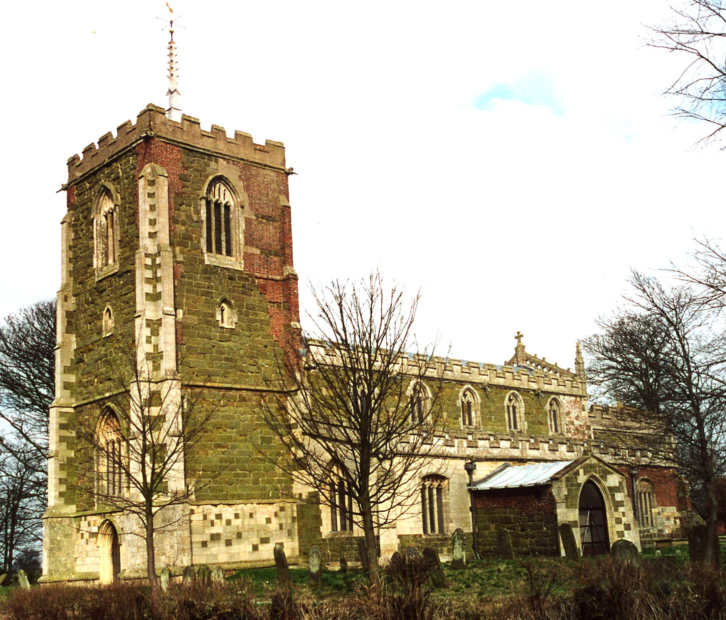
- All Saints Church was apparently built in the 14th century of Lincolnshire greenstone and masonary from an earlier Norman church or structure.
- The church became known as The Cathedral of the Marxh, It is a Grade I listed structure with English Heritage.
- All Saints Church seats 150.
- Renee Redshaw provides us with Jenny Birmingham's perspective of All Saints Church.
- The Diocese of Lincoln declared this church redundant in July, 1973. It is now maintained by the Churches Conservation Trust.
- Here is a photo of All Saints Church, taken by Ron COLE (who retains the copyright):
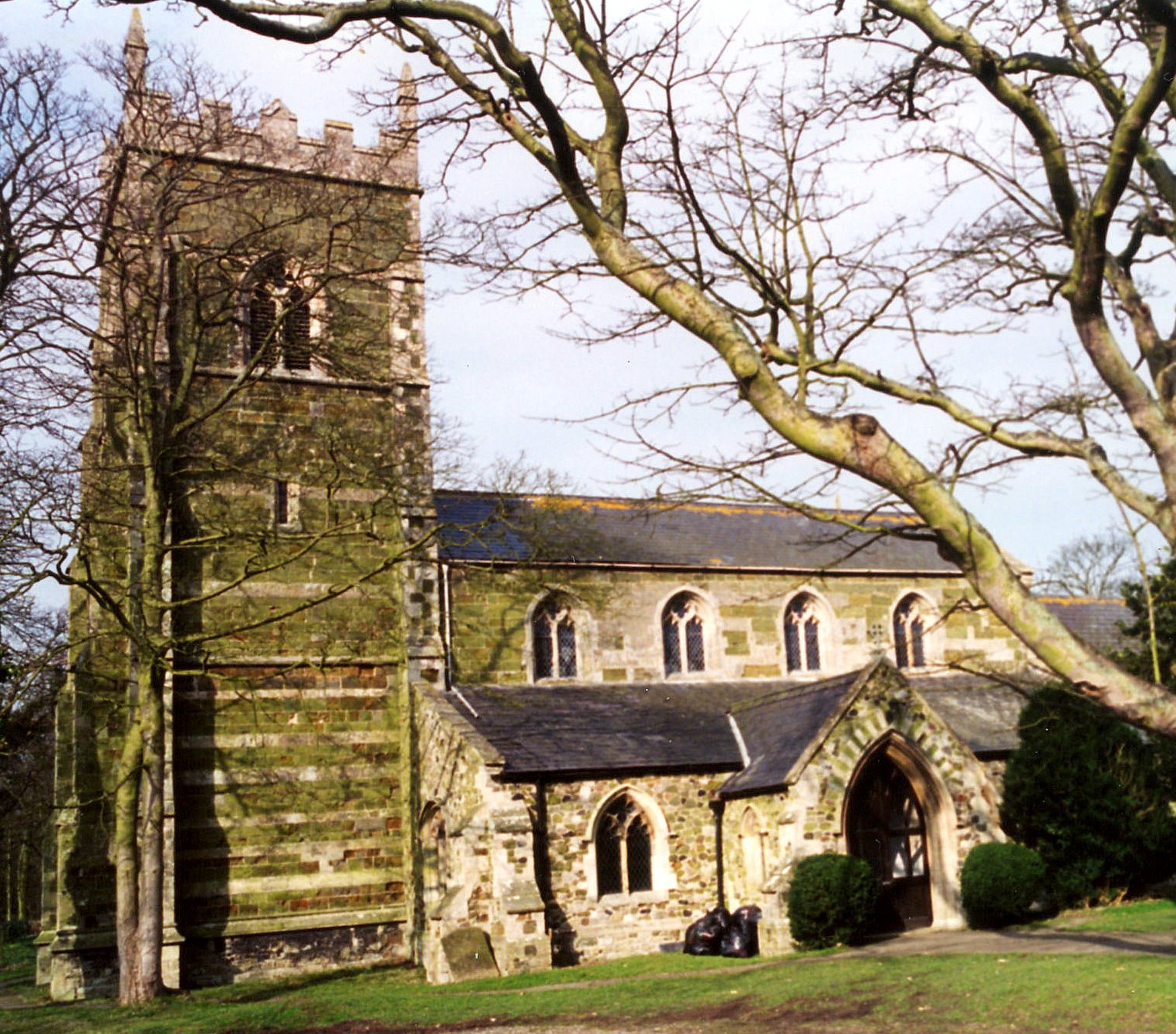
- The Church of Saint Helen was rebuilt in 1865.
- St. Helen's Church seats 260.
- There is a photograph of the Church of St. Helen on the Wendy PARKINSON Church Photos web site.
- Here is a photo of St. Helen's Church, taken by Ron COLE (who retains the copyright):
- For Theddlethorpe All Saints, parish registers begin in 1560. Bishops Transcripts cover 1561-1839, 1871-1881.
- Theddlethorpe All Saints registers are on file at the Lincolnchire Archives.
- For Theddlethorpe St. Helen, parish registers begin in 1566. Bishops Transcripts cover 1562-1839.
- We have a Parish Register Extract as a pop-up text file. It does not differentiate by church.
- The Lincolnshire FHS has published several Marriage indexes and a Burial index for the Louthesk Deanery to make your search easier.
- There was a Wesleyan Methodist chapel in the village of St. Helen's in 1855. The Primitive methodists built a chapel in St. Helen's in 1852.
- For more on researching these chapel records, see our non-conformist religions page.
- Check our Church Records page for county-wide resources.
- The parish was in the Saltfleet sub-district of the Louth Registration District.
- Check our Civil Registration page for sources and background on Civil Registration which began in July, 1837.
Theddlethorpe All Saints and Theddlethorpe St. Helen's are two scattered villages and, technically, two parishes. Both lie about 140 miles north of London. St. Helen's, sometimes called East Theddlethorpe, is on the North Sea coast, north of Mablethorpe and 11 miles east of Louth. St. Helen's, sometimes called East Theddlethorpe, is on the North Sea coast and south of the Saltfleetby parishes. All Saints is inland about 1.5 miles, and is sometimes known as West Theddlethorpe. The two parishes cover about 3,500 acres.
If you are planning a visit:
- By automobile, take the B1200 trunk road east out of Louth, then the A1031 south just as the B1200 reaches the coastline.
- Watch out for the Village Sign as photographed by Richard HOARE on Geo-graph, taken in April, 2010.
- Passenger rail service ceased in December, 1960.
- Visit our touring page for more sources.
- Ask for a calculation of the distance from Theddlethorpe to another place.
- Around 1850, the Louth and East Coast Railway built a station in St. Helen's.
- The King's Head Inn on Mill road is a good place for a family reunion. It has been around since the 16th century, but has been refurbished to modern standards.
- Richard LAW has a photograph of The King's Head Inn on Geo-graph, taken in March, 2011.
- James WILSON was the proprietor of the King's Head Public House in 1913.
- The Theddlethorpe Dunes National Nature Reserve is part of the Lincolnshire Wildlife Trust. It's on the map at TF 467 917.
- Theddlethorpe Manor was the home and seat of Thomas ALCOCK in 1842. The manor estate included both parishes.
- See our Maps page for additional resources.
You can see maps centred on OS grid reference TF460880 (Lat/Lon: 53.368701, 0.192884), Theddlethorpe which are provided by:
- OpenStreetMap
- Google Maps
- StreetMap (Current Ordnance Survey maps)
- Bing (was Multimap)
- Old Maps Online
- National Library of Scotland (Old Ordnance Survey maps)
- Vision of Britain (Click "Historical units & statistics" for administrative areas.)
- English Jurisdictions in 1851 (Unfortunately the LDS have removed the facility to enable us to specify a starting location, you will need to search yourself on their map.)
- Magic (Geographic information) (Click + on map if it doesn't show)
- GeoHack (Links to on-line maps and location specific services.)
- All places within the same township/parish shown on an Openstreetmap map.
- Nearby townships/parishes shown on an Openstreetmap map.
- Nearby places shown on an Openstreetmap map.
- David LAILY has a photograph of a World War II pillbox on Geo-graph, taken in March, 2008.
- Jonathan THACKER has another view of the WWII Pillbox on Geo-graph, taken in November, 2010.
- RAF Theddlethorpe was a bombing and gunnery range for RAF Manby. Its opening date is unrecorded so far. It is known that the range was used to test 20mm air cannons during World War II.
- There was a flying accident at RAF Theddlethorpe on 13th July 1936 in which Pilot Sgt Frank INNES, age 22, died.
- RAF Theddlethorpe was an active gunnery range in the 1970s, but it was shut down because there was a nearby gas terminal.
- RAF Theddlethorpe closed in 1973.
Sydney BAMBER, 22, son of William and Ellen BAMBER, RFA was killed in action 10 May 1917.
- Both parishes were ancient parishes in Lincolnshire and became a modern Civil Parishes when those were established.
- Both parishes were in the Marsh Division of in the ancient Calceworth Wapentake in the East Lindsey district in the parts of Lindsey.
- You can contact the local joint Parish Council concerning civic or political issues, but they are NOT staffed to assist you with family history searches.
- For today's district governance, see the East Lindsey District Council.
- Bastardy cases would be heard in the Alford petty session hearings.
- The Common Lands were enclosed here under an act by William IV. About 1/5 of the two parishes were included in the enclosure.
- In 1658, Richard SMITH left £2 and 10 shillings for the poor St. Helen's and the same amount for the poor of All Saints.
- In 1759, Elizabeth ROOK left 20 shillings for the poor of St. Helen's and another 20 shillings for the poor of All Saints.
- Date unknown, David ATKINSON left 12 shillings for the poor.
- After the 1834 Poor Law Amendment Act reforms, the parish was in the Louth Poorlaw Union.
- An Inventory of the estate of Robert SHERWOD from 1535 is archived at the Lincolnshire Archives.
- The Administration of the estate of Francis MADDISON in 1776 is at the Lincolnshire Archives.
- The Will of Joseph NEALE From 1838 is archived at the Lincolnshire Archives.
- The Will of James WOOD from Aug. 1868 is archived at the Lincolnshire Archives.
- A school was built in East Theddlethorpe in 1810 to serve both parishes. It became a National School and was enlarged and improved in 1874. By the 1920s it was known as Theddlethorpe CE School and taught juniors and senior girls. The school was closed in 1931.
- The Theddlethorpe Wesleyan Day School was transferred to Lindsey County Council c.1930 and became Theddlethorpe Council School. The school was reorganised as a junior school in September 1931, taking in juniors from the closed Theddlethorpe CE School. From 1948 until September 1999 the school was known as Theddlethorpe County Primary School, since when the current name has been used.
- J. THOMAS has a photograph of the Theddlethorpe Primary School on Geo-graph, taken in March, 2015.
- For more on researching school records, see our Schools Research page.