
Hide
Thoresway
hide
Hide
hide
Hide
hide
Hide
Hide
Thoresway, par., Lincolnshire, 4½ miles SE. of Caistor, 2,730 ac., pop. 258.
From: John BARTHOLOMEW's "Gazetteer of the British Isles (1887)"
Hide
The Caistor Library is an excellent resource with a Local History section and a Family History section.
- The parish was in the Caistor sub-district of the Caistor Registration District.
- Check our Census Resource page for county-wide resources.
- The table below gives census piece numbers, where known:
| Census Year | Piece No. |
|---|---|
| 1841 | H.O. 107 / 646 |
| 1851 | H.O. 107 / 2114 |
| 1861 | R.G. 9 / 2393 |
| 1871 | R.G. 10 / 3422 |
| 1891 | R.G. 12 / 2622 |
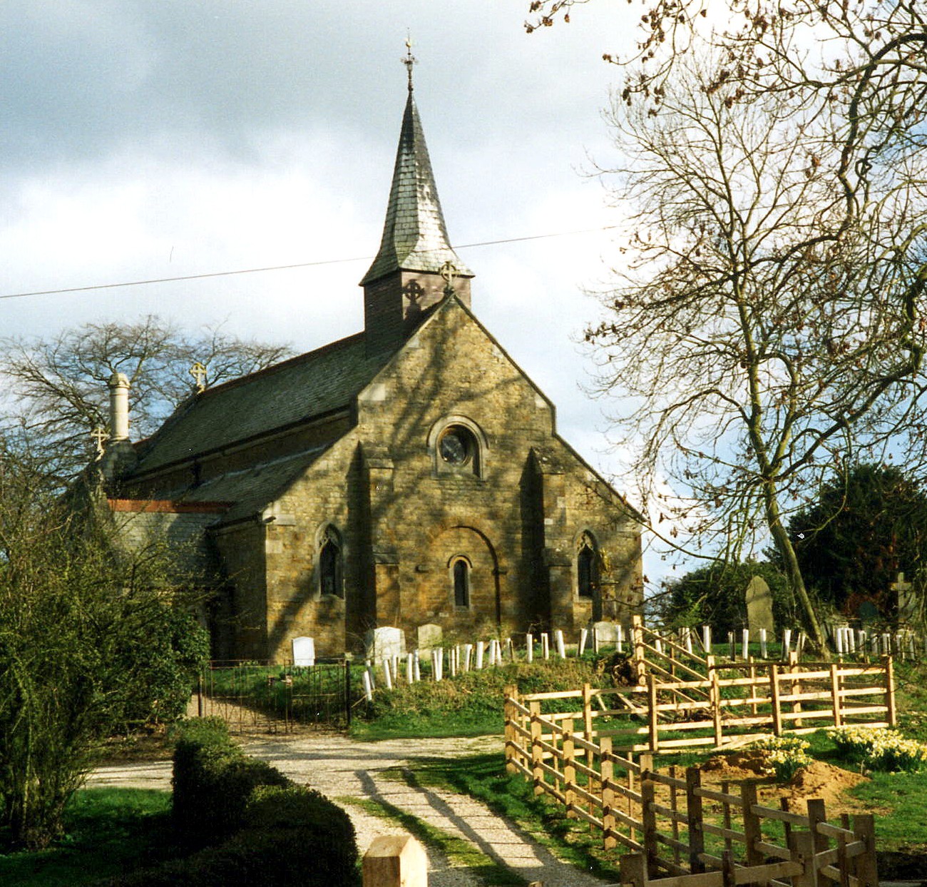
- The Anglican parish church is dedicated to Saint Mary.
- The church was built in the 12th century.
- The church used to have a western tower, but that was taken down prior to 1880 for safety reasons.
- The church seats 120.
- The church is a Grade II listed building with British Heritage.
- David WRIGHT has a photograph of St. Mary's Church on Geo-graph, taken on a sunny day in March, 2006.
- John FIRTH has a photograph of the church interior on Geo-graph, taken in June, 2011.
- Here is a photo of St. Mary's Church taken by Ron COLE (who retains the copyright):
- The Anglican parish register has baptisms and burials from 1726 and marriages from 1728.
- The Lincolnshire FHS has published several marriage indexes and a burial index for the Westwold Deanery to make your search easier.
- The church was, for a while, part of the short-lived West Walshcroft rural Deanery.
- Check our Church Records page for county-wide resources.
- The parish was in the Caistor sub-district of the Caistor Registration District.
- Check our Civil Registration page for sources and background on Civil Registration which began in July, 1837.
Thoresway is both a village and parish which sits in a valley of the Wolds, 155 miles north of London, about 5 miles south-east of Caistor and 13 miles north-west of Louth. Rothwell parish sits to the north and Walesby parish to the south-west. The parish covers about 2,800 acres.
If you are planning a visit:
- Visit our touring page for more sources.
- Ask for a calculation of the distance from Thoresway to another place.
- The parish was for centuries a rabbit warren, but was brought into cultivation in the 1800s by the application of bonemeal and lime to the soil.
- The national grid reference is TF 1797.
- You'll want an Ordnance Survey Explorer map, which has a scale of 2.5 inches to the mile.
- You might like the 1906 inch-to-the-mile map of North East Lincolnshire.
- See our Maps page for additional resources.
You can see maps centred on OS grid reference TF167966 (Lat/Lon: 53.453241, -0.244054), Thoresway which are provided by:
- OpenStreetMap
- Google Maps
- StreetMap (Current Ordnance Survey maps)
- Bing (was Multimap)
- Old Maps Online
- National Library of Scotland (Old Ordnance Survey maps)
- Vision of Britain (Click "Historical units & statistics" for administrative areas.)
- English Jurisdictions in 1851 (Unfortunately the LDS have removed the facility to enable us to specify a starting location, you will need to search yourself on their map.)
- Magic (Geographic information) (Click + on map if it doesn't show)
- GeoHack (Links to on-line maps and location specific services.)
- All places within the same township/parish shown on an Openstreetmap map.
- Nearby townships/parishes shown on an Openstreetmap map.
- Nearby places shown on an Openstreetmap map.
- This place was an ancient parish of Lincolnshire and became a modern Civil Parish when those were established.
- The parish was in the southern division of the ancient Walshcroft Wapentake in the West Lindsey district in the parts of Lindsey.
- In April, 1936, this parish gained 1,640 acres when Croxby Civil parish was abolished.
- Today's district governance is provided by the West Lindsey District Council.
- Bastardy cases would be heard in the Caistor petty session hearings.
- As a result of the 1834 Poorlaw Amendment Act, this parish became part of the Caistor Poor Law Union.
- A Public Elementary School was built here for 50 children and an additional classroom was added in 1884. Another addition occured in 1903.
- For more on researching school records, see our Schools Research page.