
Hide
Timberland
hide
Hide
hide
Hide
hide
Hide
Hide
Hide
- The parish was in the Billinghay sub-district of the Sleaford Registration District.
- Check our Census Resource page for county-wide resources.
- The table below gives census piece numbers, where known:
| Census Year | Piece No. |
|---|---|
| 1841 | H.O. 107 / 623 |
| 1861 | R.G. 9 / 2341 |
| 1871 | R.G. 10 / 3348 |
| 1891 | R.G. 12 / 2577 |
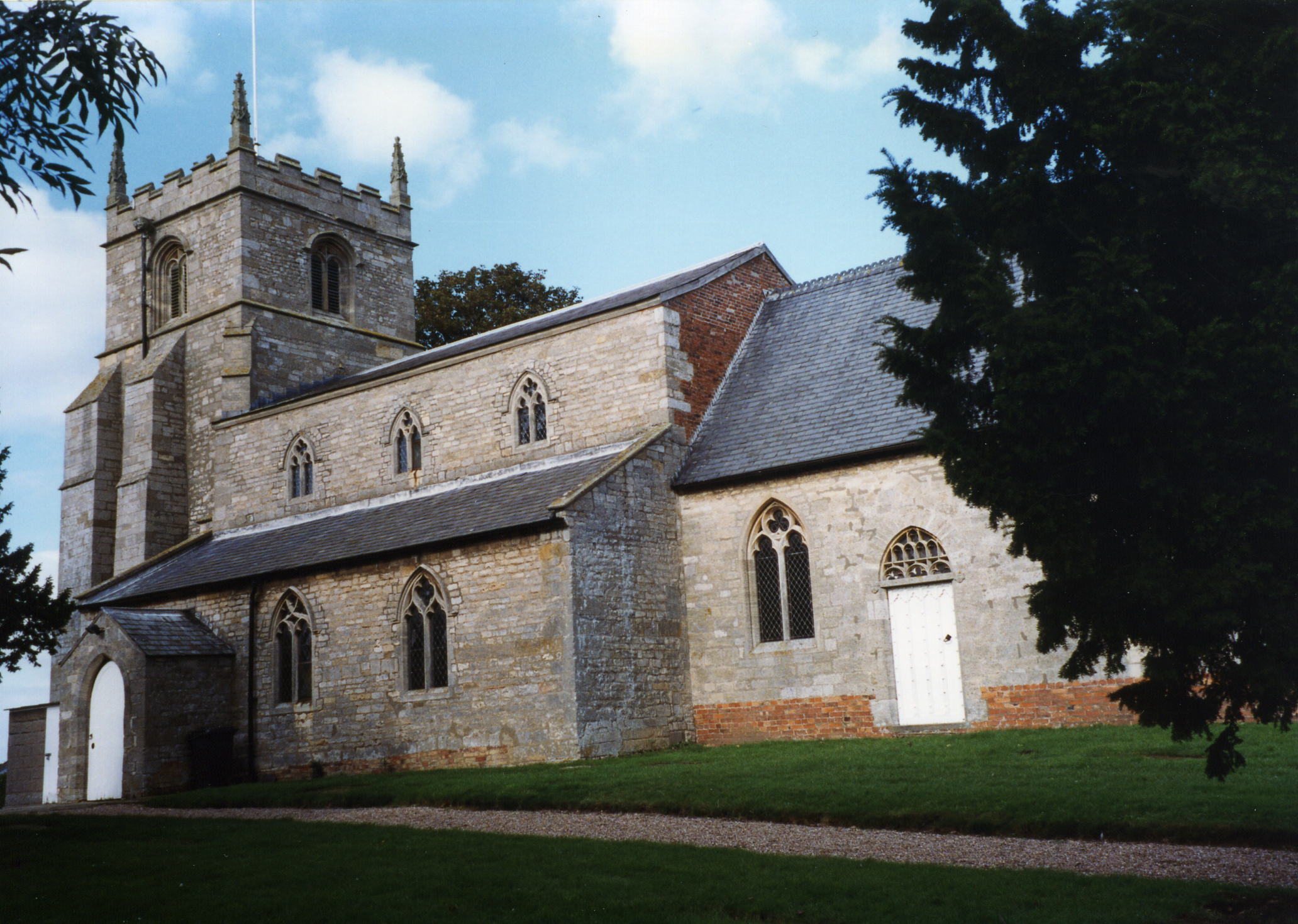
- The Anglican parish church is dedicated to Saint Andrew.
- The date of construction is unreported, but the church is said to be over 800 years old.
- The church chancel was rebuilt in 1838.
- The church was restored in 1887.
- The church seats about 200.
- Richard CROFT has a photograph of the St. Andrew's Church tower on Geo-graph, taken in February, 2008.
- Here is a photograph of St. Andrew's Church supplied by Ron COLE (who retains the copyright):
- The Anglican parish register dates from 1563, but many of the early entries are indecipherable. After 1627, the records become much more readable.
- We have the very beginning of a Parish register Extract as a text file for your review. Your additions and corrections are gladly accepted.
- The Lincolnshire FHS has the parish register on microfiche for 1660 - 1812. These fiche can be interlibrary loaned.
- The Lincolnshire FHS has published several marriage indexes and a burial index for the Graffoe Deanery to make your search easier.
- The village had a Wesleyan Methodists chapel and there was one in the Dales as well. The Primitive Methodists also had a chapel here.
- J. HANNAN-BRIGGS has a photograph of the Wesleyan Chapel on Geo-graph, taken in July, 2011.
- For more on researching these chapel records, see our non-conformist religions page.
- Check our Church Records page for county-wide resources.
- The parish was in the Billinghay sub-district of the Sleaford Registration District.
- Check our Civil Registration page for sources and background on Civil Registration which began in July 1837.
Timberland is both a village, a township and a parish 128 miles north of London, just south of the River Welland, due west of Coningsby. The parish is bounded on the north by Martin parish, to the west by Thorpe Tilney township and by the Tattershall and Coningsby parishes to the east. The area is flat fenland, drained by many small canals and covers about 4,700 acres.
If you are planning a visit:
- The village is at the intersection of two trunk roads: the B1191 and the B1189, about seven miles north of Sleaford.
- See our touring page for more sources.
In John Marius WILSON's Imperial Gazetteer of England and Wales, 1870-72:
"TIMBERLAND, a township and a parish in Sleaford district, Lincoln. The township lies 4½ miles WSW of Kirkstead r. station, and 9 NE by N of Sleaford; and has a post-office under Sleaford. Real property, £4,856. Pop., 589. Houses, 121. The parish includes Martin and Thorpe-Tilney hamlets, and comprises 9,190 acres. Pop., 1,618. Houses, 325. The property is divided among a few. The living is a vicarage in the diocese of Lincoln. Value, £450. Patron, Sir T. Whichcote, Bart. The church is good; and there are a Wesleyan chapel, a national school, and charities £5. "
- Ask for a calculation of the distance from Timberland to another place.
- The national grid reference is TF 1258.
- You'll want an Ordnance Survey Explorer map, which has 2.5 inches to the mile scale.
- See our Maps page for additional resources.
You can see maps centred on OS grid reference TF120584 (Lat/Lon: 53.111038, -0.328248), Timberland which are provided by:
- OpenStreetMap
- Google Maps
- StreetMap (Current Ordnance Survey maps)
- Bing (was Multimap)
- Old Maps Online
- National Library of Scotland (Old Ordnance Survey maps)
- Vision of Britain (Click "Historical units & statistics" for administrative areas.)
- English Jurisdictions in 1851 (Unfortunately the LDS have removed the facility to enable us to specify a starting location, you will need to search yourself on their map.)
- Magic (Geographic information) (Click + on map if it doesn't show)
- GeoHack (Links to on-line maps and location specific services.)
- All places within the same township/parish shown on an Openstreetmap map.
- Nearby townships/parishes shown on an Openstreetmap map.
- Nearby places shown on an Openstreetmap map.
There are two Commonwealth War Graves in St. Andrew's churchyard. One from World War I and one from World War II.
There is a photograph of the memorial plaques on a butress of the church tower at Geo-graph, taken in February, 2008 by Richard CROFT.
There is a photograph of the memorial plaques and a list of names at the Roll of Honour site.
Private Arthur CREASEY of the 38th Btln. Machine Gun Corps died on 3 November, 1918, and is buried in St. Andrew's churchyard.
Private Geoge William WELLS of the General Service Corps died on 13 Feb. 1943, age 19, and is also buried in St. Andrew's churchyard. He was the son of William and Alice WELLS, of Woodhall Spa.
- This place was an ancient parish in Lincolnshire and became a modern Civil Parish when those were established.
- The parish was in the first division of the ancient Langoe Wapentake in the North Kesteven district in the parts of Kesteven.
- In April, 1931, this Civil Parish gained 1,929 acres when Thorpe Tilney Civil Parish was abolished.
- You may contact the local Parish Council regarding civic or political issues. They are NOT staffed or funded to assist you with family history searches.
- For today's district governance, see the North Kesteven District Council.
- Bastardy cases would be heard in the Sleaford petty session hearings every Monday.
- The Common Lands were enclosed here in 1789.
- After the Poor Law Amendment Act reforms of 1834, the parish became part of the Sleaford Poor Law Union.
- A Church School was built here in 1843.
- Jo TURNER has a photograph of this Old School on Geo-graph, taken in March, 2015.
- Timberland village had a mixed school built in 1840 to hold up to 85 children.
- Timberland Dales had a mixed school built in 1875 to hold up to 70 children.
- For more on researching school records, see our Schools Research page.