
Hide
Toynton All Saints
hide
Hide
hide
Hide
hide
Hide
Hide
Hide
- The parish was in the Spilsby sub-district of the Spilsby Registration District.
- Check our Census Resource page for county-wide resources.
- The table below gives census piece numbers, where known:
| Census Year | Piece No. |
|---|---|
| 1841 | H.O. 107 / 647 |
| 1851 | H.O. 107 / 2109 |
| 1861 | R.G. 9 / 2374 |
| 1871 | R.G. 10 / 3391 & 3393A |
| 1901 | R.G. 13 / 3075 |
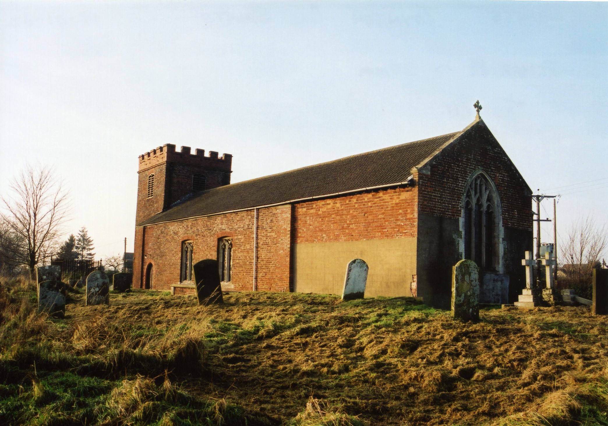
- The Anglican parish church is dedicated to All Saints.
- Parts of the church building appear to date from the 13th Century.
- The church was restored in 1904.
- The church can seat 200.
- The church is a Grade II listed building with British Heritage.
- Here is a photo of All Saints Church, taken by Ron Cole (who retains the copyright):
- We have a few entries in our Toynton All Saints Parish register extract file. Your additions are welcome.
- The Lincolnshire FHS has published several marriage indexes and a burial index for the Bolingbroke Deanery to make your search easier.
- The Lincolnshire Archives hold: bap. 1689-1925; Mar. 1691-1955; Bur. 1689-1925; BTs 1562-1843.
- The Wesleyan Methodists built a chapel here in 1860 and have extended it twice. For information and assistance in researching these chapels, see our non-conformist religions page.
- Check our Church Records page for county-wide resources.
- The parish was in the Spilsby sub-district of the Spilsby Registration District.
- Check our Civil Registration page for sources and background on Civil Registration which began in July, 1837.
Toynton All Saints is a village and a parish which lies 125 miles north of London, 1.5 miles south of Spilsby and east-south-east of Horncastle. East Keal parish lies to the west and Stickford parish to the south-west. The parish covers about 1,400 acres.
The village is scattered along the main street. If you are considering a visit to the parish:
- By automobile, take the A16 trunk road south out of Spilsby or north out of Stickford.
- Check out our touring page.
- Ask for a calculation of the distance from Toynton All Saints to another place.
- In the medieval period, circa 1300, ceramic pottery and tiles were made here.
- There is a tower windmill in the parish from the 19th century which is now a Grade II listed building with British Heritage.
- See our Maps page for additional resources.
You can see maps centred on OS grid reference TF392640 (Lat/Lon: 53.155263, 0.079823), Toynton All Saints which are provided by:
- OpenStreetMap
- Google Maps
- StreetMap (Current Ordnance Survey maps)
- Bing (was Multimap)
- Old Maps Online
- National Library of Scotland (Old Ordnance Survey maps)
- Vision of Britain (Click "Historical units & statistics" for administrative areas.)
- English Jurisdictions in 1851 (Unfortunately the LDS have removed the facility to enable us to specify a starting location, you will need to search yourself on their map.)
- Magic (Geographic information) (Click + on map if it doesn't show)
- GeoHack (Links to on-line maps and location specific services.)
- All places within the same township/parish shown on an Openstreetmap map.
- Nearby townships/parishes shown on an Openstreetmap map.
- Nearby places shown on an Openstreetmap map.
For a photograph of the Toynton All Saints War Memorial and the names on it, see the Roll of Honour site.
- The parish was in the East division of the ancient Bolingbroke Wapentake in the East Lindsey district and parts of Lindsey.
- The parish was also in the Bolingbroke Soke.
- Kelly's 1900 Directory of Lincolnshire places the parish (perhaps erroneously) in the South Lindsey division of the county, as does the 1913 Directory.
- When the Fens were re-alloted in 1881, a portion of this parish's fen allotment went to form the new Wildmore parish.
- For today's district governance, see the East Lindsey District Council.
- Bastardy cases would be heard in the Spilsby petty session hearings every other Monday.
- As a result of the 1834 Poor Law Amendment Act, the parish became part of the Spilsby Poor Law Union.
- A National School was built here in 1845.
- See our Schools page for more information on researching school records.