
Hide
Tydd St. Mary
hide
Hide
hide
Hide
hide
Hide
Hide
hide
Hide
Hide
The Library at Spalding will prove useful in your research.
The Library at Holbeach may also prove useful in your research.
Evelyn SIMAK has a photograph of the Public footpath through St Mary's churchyard on Geo-graph, taken in January, 2011.
- Tydd St. Mary was part of the Long Sutton sub-district of the Holbeach Registration District.
- Check our Census Resource page for county-wide resources.
- The table below gives census piece numbers, where known:
| Census Year | LDS Film/Fiche No. | Piece Numbers |
| 1841 | 0438754 | H.O. 107 / 612 |
|---|---|---|
| 1851 | 0087726 | H.O. 107 / 2097 |
| 1861 | 0542954 | R.G. 9 / 2327 |
| 1871 | 0839350 | R.G. 10 / 3327 |
| 1881 | 1341765 | R.G. 11 / 320x |
| 1891 | 6097677, 3 fiche | R.G. 12 / 2567 |
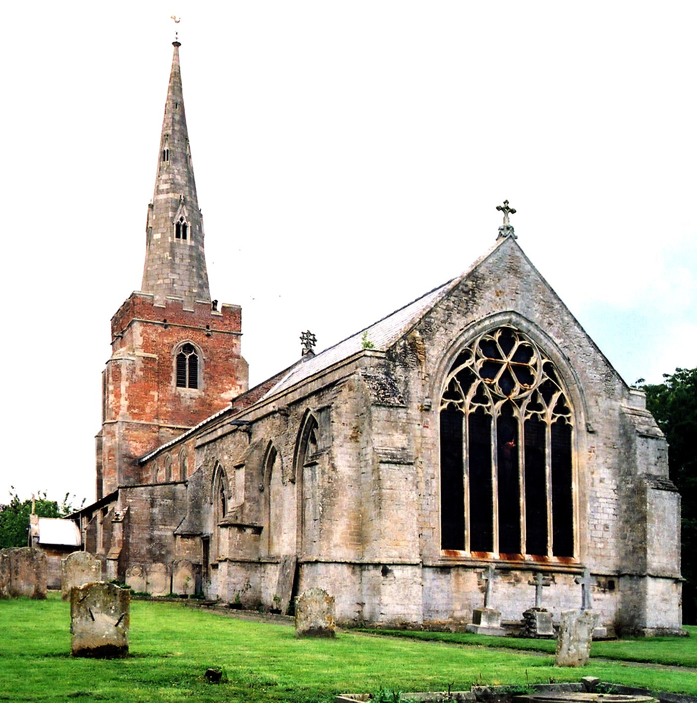
- The Anglican Church is dedicated to Saint Mary.
- The church has some portions of the structure dating back to around 1200.
- The church chancel was restored in 1869.
- The church was modernised in 1927-29.
- Nicholas BREAKSPEAR, a former rector of this church, was made Pope in 1154 under the name "Adrian IV".
- The church seats 262.
- The church is Grad I listed with English Heritage.
- Evelyn SIMAK has a photograph of St. Mary's Church on Geo-graph, taken in January, 2011.
- Here is a photo of St. Mary's Church taken by Ron COLE (who retains the copyright):
- Anglican parish registers exist from 1540.
- We have a partial Register Extract for St. Mary's. Your contributions would be appreciated.
- The Family History Library (FHL) in Salt Lake City has the parish register on microfilms covering 1540 to 1987 and the Bishop's transcripts from 1561 to 1851 on another microfilm. Parish register printouts are also available on microfilm from the FHL.
- Check the marriage and burial indexes available for the East Elloe Deanery.
- The Wesleyan Methodists had a chapel here, as did the Primitive and Free Church Methodists who built theirs in Tydd Gote.
- For information and assistance in researching these chapels, see our non-conformist religions page.
- Check our Church Records page for county-wide resources.
- Tydd St. Mary was part of the Long Sutton sub-district of the Holbeach Registration District.
- Check our Civil Registration page for sources and background on Civil Registration which started in July, 1837.
Tydd St. Mary is both a village and parish about 105 miles north of London, about 9 miles east of Spalding and 5 miles north of Wisbech and a mile south of the A17 trunk road. It includes the hamlet of Tydd Gote (part of which is in Cambridgeshire). The parish sits like a cap on top of Cambridgeshire, with a short tail trailing off to the southwest. Sutton Bridge parish lies to the northeast and Tydd St. Giles (in Cambridge) lies to the south. The River Nene forms a portion of the eastern boundary and the South Holland Main Drain a portion of the northern border. The area is flat and marshy Fen land and covers over 4,600 acres.
Tydd Gote (or Gowt) is a hamlet in the parish, about a half mile south of Tydd St. Mary and it lies partly in Lincolnshire and partly in Tydd St. Giles, Cambridgeshire. If you are planning a visit:
- The Midland and Great Northern Joint Railway came to Tydd in 1866 and closed in 1959.
- See our touring page for visitor services.
- Ask for a calculation of the distance from Tydd St. Mary to another place.
- The village was struck by a weak F0/T0 tornado on 23 November 1981, as part of the record-breaking nationwide tornado outbreak on that day.
Richard CROFT has a photograph of Tysdale Manor on Geo-graph, taken in August, 2012. It was re-modelled in the 17th and 18th centuries.
- See our Maps page for additional resources.
You can see maps centred on OS grid reference TF446186 (Lat/Lon: 52.745685, 0.140725), Tydd St. Mary which are provided by:
- OpenStreetMap
- Google Maps
- StreetMap (Current Ordnance Survey maps)
- Bing (was Multimap)
- Old Maps Online
- National Library of Scotland (Old Ordnance Survey maps)
- Vision of Britain (Click "Historical units & statistics" for administrative areas.)
- English Jurisdictions in 1851 (Unfortunately the LDS have removed the facility to enable us to specify a starting location, you will need to search yourself on their map.)
- Magic (Geographic information) (Click + on map if it doesn't show)
- GeoHack (Links to on-line maps and location specific services.)
- All places within the same township/parish shown on an Openstreetmap map.
- Nearby townships/parishes shown on an Openstreetmap map.
- Nearby places shown on an Openstreetmap map.
- In the church there is a mural tablet of alabaster and marble as a memorial to Lieut.-Col Samuel LONG who died in 1881 at age 82. At one time he held the title of Deputy Lieutenant.
- In 1927 a handsome lychgate was built as a war memorial, with a marble tablet having the names of the men who perished in World War I.
- The Royal Flying Corps opened an airfield here in August 1917 as a Home Defence airfield for night patrols.
- The airfield was closed in May 1919 and returned to agricultural use.
- The field is now listed under the Airfields of Britain Conservation Trust.
- The name Tydd is from the Old English tydd, or "shrubs or brushwood".
[A. D. Mills, "A Dictionary of English Place-Names," Oxford University Press, 1991]
- In 1871, Richard YOUNG who resided in this parish was appointed Sheriff of London and Middlesex. He died two days after being appointed. Richard YOUNG owned over 43 vessels during his life.
- Woad was harvested and processed in this area until the 1920's. See "Woad in the Fens", Norman T. WILLS, published by L.J. Ruskin & sons (3rd Ed. 1979).
- This place was an ancient parish in Lincolnshire and became a modern Civil Parish when those were established.
- The parish was in the ancient Elloe Wapentake in the South Holland district in the parts of Holland.
- J. THOMAS has a photograph of the Tydd St. Mary Village Hall on Geo-graph, taken in October, 2015.
- You can contact the local Parish Council concerning civic or political issues, but they are NOT staffed to assist you with family history searches.
- For today's district governance, visit the South Holland District Council site.
- This Civil Parish was reduced in size when Central WIngland Civil Parish was created in Noivember, 1897.
- In April, 1932, the Civil Parish borders were changed by 16 acres transfered to Sutton Bridge Civil Parish and 28 acres received from that same parish.
- On that same date, this Civil Parish gained 139 acres from Tydd St. Giles Civil Parish in return for 103 acres given to that same parish.
- Bastardy cases would be heard in the Elloe (Spalding) petty session hearings.
- After the Poor Law Amendment Act reforms of 1834, the parish became part of the Holbeach Poor Law Union.
Year Inhabitants 1801 607 1811 629 1831 960 1841 920 1851 1,107 1871 974 1881 928 1891 837 1901 821 1911 854 1921 1,026
- The Free School was founded in 1740 by Dame Martha TRAFFORD, who left £165 to fund it. It was enlarged in 1888.
- A National School for infants was built here prior to 1900.
- The parish school, built in 1961, is in the south end of the village and the address is:
Churchway
Tydd St Mary
Wisbech PE13 5QY
ENGLAND
Tele: 01945 420269
- The school has a website, but no family or school history data.
- The school has a very nice Library for the children that was renovated in 2018.
- For more on researching school records, see our Schools Research page.