
Hide
Waddington
hide
Hide
hide
Hide
hide
Hide
Hide
Hide
| Maltkin Lane, Waddington, Society of Friends (Quaker) |
- The parish was in the Southwest sub-district of the Lincoln Registration District.
- There is an index and transcription of the 1861 census now available on the Wendy Parkinson web site.
- Check our Census Resource page for county-wide resources.
- The table below gives census piece numbers, where known:
| Census Year | Piece No. |
|---|---|
| 1841 | H.O. 107 / 619 |
| 1861 | R.G. 9 / 2354 |
| 1871 | R.G. 10 / 3365 |
| 1881 | R.G. 11 / 3235 |
| 1891 | R.G. 12 / 2587 |
| Maltkin Lane, Waddington, Society of Friends (Quaker) |
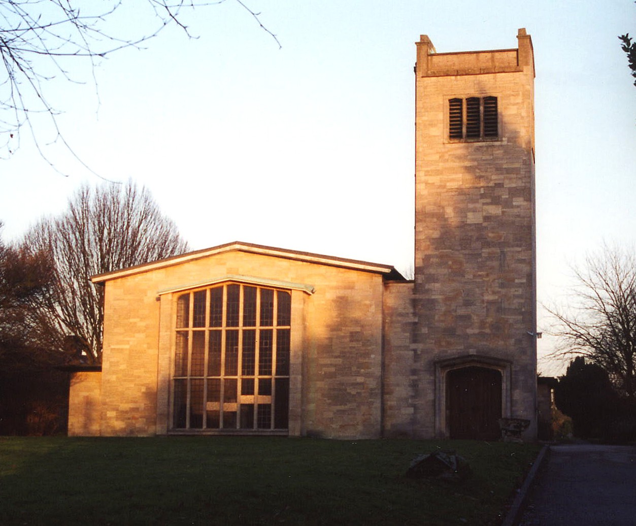
- The Anglican parish church is dedicated to Saint Michael.
- The church was restored in 1779 and 1867.
- The church seats about 250.
- Waddington St Michael's was bombed in WWII (there is a nearby RAF Station). The new church was built in 1952-54 and is said by some to resemble a grain silo.
- Gary BROTHWELL captured the clean lines of the new church at Geo-graph in a photo taken in 2010.
- Here is a photo of St. Michael's Church, taken by Ron Cole (who retains the copyright):
- We have a handful of entries in our Parish Register Extract text file. Your additions are welcome.
- There is a local person who is the Resident Expert on Waddington: Jean Towers, 'Malpas', 436 Brant Road, Waddington, Lincoln LN5 9AN.
- The Lincolnshire FHS has published several marriage indexes and a burial index for the Graffoe Deanery to make your search easier.
- The Wesleyan Methodists had a chapel here prior to 1842, as did the Friends' (Quakers). The Free Methodists had a chapel here prior to 1900. For information and assistance in researching these chapels, see our non-conformist religions page.
- Check our Church Records page for county-wide resources.
- The parish was in the Southwest sub-district of the Lincoln Registration District.
- Check our Civil Registration page for sources and background on Civil Registration which began in July, 1837.
This village and parish lie just 4 miles south of Lincoln in Lincolnshire, across the River Witham and just south of Bracebridge Heath. Branston parish is to the northeast and Harmston to the south. The parish covers about 3,330 acres of land.
The village of Waddington sits on a limestone eminence. It has grown a great deal in the last century. If you are planning a visit:
- Take the A15 trunk road, south out of Lincoln and turn off at the southbound A607 trunk road. Follow that one mile south to Waddington village.
- There are facts and photographs at Domesday Reloaded for your edification.
- See our touring page for more sources.
- Ask for a calculation of the distance from Waddington to another place.
- The village held an annual feast each October 11th.
- In 1838 George BOOLE, later to be a famous mathematician, took over Hall's Acadamy. He moved back to the town of Lincoln in 1840. BOOLE is the "inventor" of Boolean Logic, a simple set of basic logic rules for problem solving. BOOLE's work is a foundation stone of electronic computing and BOOLE is considered a founder of digital computing.
- The village had a railway station 1 mile to the west on the Grantham and Lincoln branch of the Great Northern Railway.
- Peter LANGSDALE provides a picture of the Horse and Jockey P. H. at Geo-graph in a photo taken in 2002. Here are the names associated with the Inn in various Directories:
| Year | Person |
|---|---|
| 1842 | John SLIGHT, vict. |
| 1868 | Frederick TAYLOR. |
| 1872 | Frederick TAYLOR, farmer & vict. |
| 1882 | William Butler Martin HOWDEN, vict. |
| 1913 | Edwin George CHOPPING |
| 1930 | Wltr. WALKER |
- The Three Horse Shoes P. H. provided a place to swap stories and news. It may have been just "Horse Shoes P. H." prior to about 1875. Here are the names associated with the Inn in various Directories:
| Year | Person |
|---|---|
| 1842 | Wm. WOOD, vict. |
| 1868 | William MILLINGTON |
| 1872 | William MILLINGTON, vict. |
| 1882 | Henry ONYON, bricklayer & vict. |
| 1913 | John Charles TAYLOR |
| 1930 | Jn. Wm. COOK |
- Peter LANGSDALE provides a picture of the Wheatsheaf Inn at Geo-graph in a photo taken in 2002. Here are the names associated with the Inn in various Directories:
| Year | Person |
|---|---|
| 1842 | Robert Fox, vict. |
| 1868 | William RIDLEY |
| 1872 | John TAYLOR, vict. |
| 1882 | Edward Francis TYE, vict. |
| 1913 | Frank THACKER |
| 1930 | William TRIGG |
Edward Francis TYE was born in Newball, LIN, circa 1833.
- See our Maps page for additional resources.
You can see maps centred on OS grid reference SK973623 (Lat/Lon: 53.148964, -0.546592), Waddington which are provided by:
- OpenStreetMap
- Google Maps
- StreetMap (Current Ordnance Survey maps)
- Bing (was Multimap)
- Old Maps Online
- National Library of Scotland (Old Ordnance Survey maps)
- Vision of Britain (Click "Historical units & statistics" for administrative areas.)
- English Jurisdictions in 1851 (Unfortunately the LDS have removed the facility to enable us to specify a starting location, you will need to search yourself on their map.)
- Magic (Geographic information) (Click + on map if it doesn't show)
- GeoHack (Links to on-line maps and location specific services.)
- All places within the same township/parish shown on an Openstreetmap map.
- Nearby townships/parishes shown on an Openstreetmap map.
- Nearby places shown on an Openstreetmap map.
- David GASH of this parish served in the 65th Foot Regiment at Waterloo and was discharged in 1808.
- The Royal Flying Corps opened an airfield here in November 1916, initially as a training field.
- The airfield was closed in 1919.
- The RAF (which used to be the Royal Flying Corps) re-opened the airfield here in October 1926. The airfield was rebuilt in 1936 in order to be used by Bomber Command.
- The village suffered 71 homes damaged during a 9 May 1941 Luftwaffe raid when two aerial mines detonated. 11 or 12 people were killed.
- See Lincs Mag article about Renee Woods, one of the seven girls who were killed, has a photograph of the damaged NAFFI building
- Another German raid in May of 1941 destroyed the parish church.
- On 20 Feb 1942 a Lancaster bomber overran the end of the runway, damaging the aircraft. There were no casualties.
- On 20 May 1942 the wing failed on an aircraft being tested by pilot E. W. WRIGHT.
- On 6 June 1942 another Lancaster bomber overran the end of the runway, damaging the aircraft. There were no casualties.
- On 7 Nov 1942 two Lancaster bombers collided over Waddington. Both planes were destroyed and there were no survivors.
- The airfield was closed again during May 1943 while the runways were reconstructed.
- On 22 Dec 1944 a Lancaster bombers came down in bad weather about a mile from the airfield. There was only one survivor.
- Shortly after World War II ended, the USAF Strategic Air Command used the airfield for its B-29 Superfortress aircraft.
- The airfield was closed again from the summer of 1953 through 1955 while the runways were upgraded to modern aircraft standards.
- RAF Waddington is still an active RAF station.
- There is an RAF Waddington website, but no information for family historians.
- Peter LANGSDALE provides a picture of the Vulcan crash graves at Geo-graph in a photo taken in 2002. These three men died in the 1956 crash of their Vulcan bomber in London.
For another photograph of the Waddington War Memorial and the list of names on it, see the Roll of Honour site.
- The parish was in the ancient Liberty of Lincoln and the Boothby Graffoe Wapentake in the North Kesteven division of the county, in the parts of Kesteven.
- You can contact the local Parish Council concerning civic or political issues, but they are NOT staffed to assist you with family history searches.
- For today's district governance, see the North Kesteven District Council.
- Bastardy cases would be heard in the LIncoln South petty session hearings.
- The Common Lands were enclosed here during the reign of Charles I.
- As a result of the 1834 Poor Law Amendment Act, the parish became part of the Lincoln Poor Law Union.
- A Public Elementary School was built here in 1854 to hold up to 100 children. In 1912 the average attendance was 94.
- An Infants' School opened here in 1906 to hold up to 60 children. In 1912 the average attendance was 40.
- For more on researching school records, see our Schools Research age.