
Hide
West Rasen
hide
Hide
hide
Hide
hide
Hide
Hide
Rasen, West, par. and vil., Lincolnshire, on river Rasen, 3m. W. of Market Rasen, 2,720 ac., pop. 251; P.O.
From: John BARTHOLOMEW's "Gazetteer of the British Isles (1887)"
Hide
The Caistor Library is an excellent resource with a Local History section and a Family History section.
Alternatively, you can use the nearby Market Rasen Library as a resource, as well.
J. THOMAS has a photograph of All Saint's church graveyard on Geo-graph, taken in June, 2013. Take care around those leaning gravestones.
- The parish was in the Market Rasen sub-district of the Caistor Registration District.
- Check our Census Resource page for county-wide resources.
- The table below gives census piece numbers, where known:
| Census Year | Piece No. |
|---|---|
| 1841 | H.O. 107 / 642 |
| 1851 | H.O. 107 / 2115 |
| 1861 | R.G. 9 / 2394 |
| 1871 | R.G. 10 / 3424 |
| 1891 | R.G. 12 / 2623 |
| Our Lady of the Rosary, West Rasen, Roman Catholic |
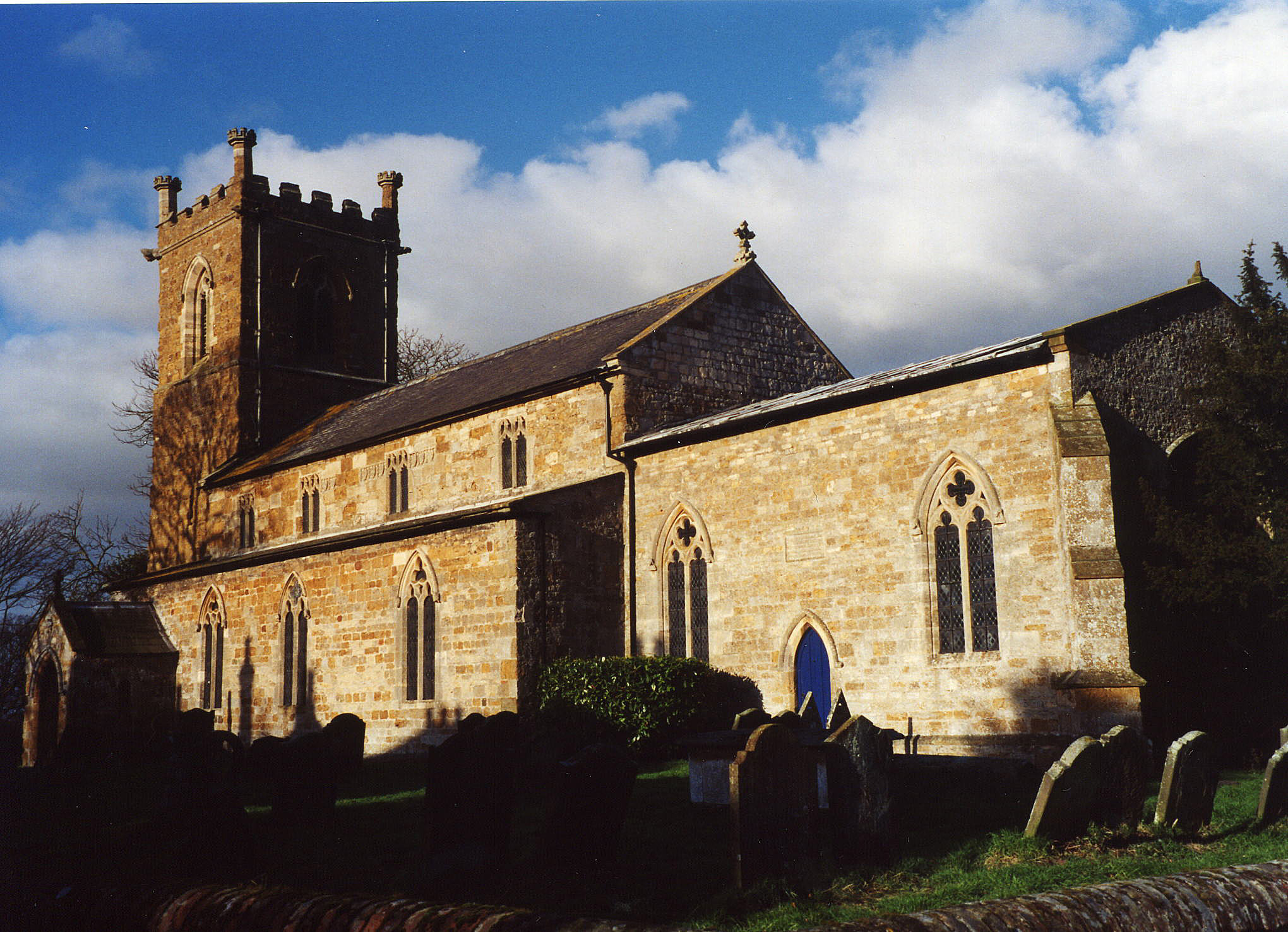
- The Anglican parish church is built of sandstone and ironstone in the 11th century and dedicated to All Saints.
- The church is of Norman origin (some Saxon arches exist) and was partly rebuilt in 1829.
- The church was repaired and restored in 1870.
- The church seats 120.
- There is the base of an ancient cross in the churchyard. Richard CROFT has a photograph of the Churchyard Cross on Geo-graph, taken in June, 2013.
- A photograph of All Saints Church is at the Wendy PARKINSON English Church Photographs site.
- Richard CROFT has a photograph of All Saints' Church on Geo-graph, taken in April, 2006.
- Here is a photo of All Saints Church, taken by Ron COLE (who retains the copyright):
- Thes parish register dates from 1683.
- The Lincolnshire FHS has published several marriage indexes and a burial index for the Westwold Deanery to make your search easier.
- The church has, during eclessiastical boundary changes, been part of the West Walshcroft rural Deanery.
- The parish had a small Catholic school chapel, dedicated to Our Lady of the Rosary. It was served from Market Rasen. For information and assistance in researching these chapels, see our non-conformist religions page.
- Check our Church Records page for county-wide resources.
- The parish was in the Market Rasen sub-district of the Caistor Registration District.
- Check our Civil Registration page for sources and background on Civil Registration which began in July, 1837.
The Village Stocks still stand by the West Rasen Village Hall & Heritage Centre as photographed and stored on Geo-graph, taken in CHRIS ? in August, 2013.
This village and parish are 3 miles west of Market Rasen parish. The parish covers about 3,180 acres.
The village is on the River Rase. If you are planning a visit:
- See what's on at the West Rasen Heritage Centre during your visit.
- Chris has a photograph of the Village Hall and Heritage Centre on Geo-graph, taken in August, 2013.
- J. THONAS Has a photograph of the River RAden in normal summer flow on Geo-graph, taken in June, 2013.
- Check out our touring page for resources.
- Ask for a calculation of the distance from West Rasen to another place.
- The parish has a 14th century horse-bridge of three arches across the Rase River.
- Threre is a 1950's photograph of West Rasen VIllage on E-BAY taken by ajohn FRITH.
- Richard CROFT has a photograph of the packhorse bridge on Geo-graph, taken in April, 2006.
- Mandy CLEGG also has a photograph of the Old Pack Horse Bridge on Geo-graph, taken in May, 2018.
- An adjacent road bridge was built in 1856.
- See our Maps page for additional resources.
You can see maps centred on OS grid reference TF064892 (Lat/Lon: 53.38893, -0.40159), West Rasen which are provided by:
- OpenStreetMap
- Google Maps
- StreetMap (Current Ordnance Survey maps)
- Bing (was Multimap)
- Old Maps Online
- National Library of Scotland (Old Ordnance Survey maps)
- Vision of Britain (Click "Historical units & statistics" for administrative areas.)
- English Jurisdictions in 1851 (Unfortunately the LDS have removed the facility to enable us to specify a starting location, you will need to search yourself on their map.)
- Magic (Geographic information) (Click + on map if it doesn't show)
- GeoHack (Links to on-line maps and location specific services.)
- All places within the same township/parish shown on an Openstreetmap map.
- Nearby townships/parishes shown on an Openstreetmap map.
- Nearby places shown on an Openstreetmap map.
- This place was an ancient parish in Lincoln county and became a modern Civil Parish when those were established.
- The parish was in the ancient Walshcroft Wapentake in the West Lindsey district in the parts of Lindsey.
- In Kelly's 1913 Directory of Lincolnshire, the parish was listed, perhaps erroneously, as being in the East Lindsey district.
- Today's district governance is provided by the West Lindsey District Council.
- Bastardy cases would be heard in the Grimsby petty session hearings.
- The Common Land was enclosed here in 1814.
- After the 1834 Poor Law Amendment Act reforms, this parish became part of the Caistor Poor Law Union.
- The children of this parish attended schools in Newton and Osgodby.
- A National School existed here in 1871, but that building was replaced in 1875 with a new one. The new school appears to have closed around 1880.
- A Catholic school was built here in 1872 to accomodate 50 children.
- See our Schools page for more information on researching school records.