
Hide
Woolsthorpe (by Belvoir)
hide
Hide
hide
Hide
hide
Hide
Hide
Hide
The Library at Grantham will prove useful in your research.
Jonathan THACKER has a photograph of Woolsthorpe cemetery on Geo-graph, taken in May, 2019.
- The parish was in the Denton sub-district of the Grantham Registration District.
- In an 1890 re-organization, the parish was allocated to the new "Grantham South" sub-district of the Grantham Registration District.
- Check our Census Resource page for county-wide resources.
- The Lincolnshire Family History Society has published surname indexes on fiche or in booklet form for each of these census years under the title "Grantham". These are available by credit card from the Federation of Family History Societies Bookstore with worldwide shipping. Please note that these are SURNAME indexes only, and do not show first names, age or relationships.
| Year | LDS Film/Fiche No. | Piece Numbers | LFHS Surname Index |
|---|---|---|---|
| 1841 | 0438756 | H.O. 107 / 615 & 624 | Fiche |
| 1851 | 0087731 | H.O. 107 / 2102 | Booklet |
| 1861 | 0542957 | R.G. 9 / 234x | Fiche |
| 1871 | 0839359 | R.G. 10 / 3357 | Booklet or Fiche |
| 1881 | 1341769 | R.G. 11 / 3227 | |
| 1891 | 6097692, 4 fiche | R.G. 12 / 2582 | Booklet or Fiche |
- The parish church was originally dedicated to Saint Mary.
- The parish church was burned down by Parliamentary forces in 1660 during the Civil War. Services were afterward held in the chapel of St. Mary, a small building in the middle of the village. Burials still took place in the old churchyard.
- The old churchyard came to be known as "Woolsthorpe Upper Cemetery."
- The chapel of St. Mary was taken down in 1793 (some sources say 1787) and a church of the same name erected on the site.
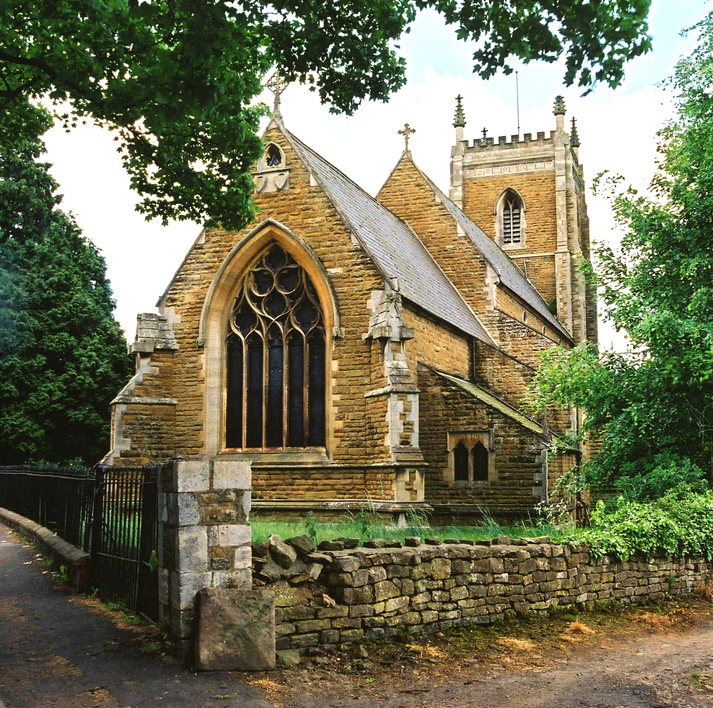
- The present Anglican parish church was built in 1845-7 of stone and dedicated to Saint James.
- The tower was completed in 1893 as a memorial to the father and brother of the Duke of Rutland.
- The church seats 400.
- There is a photograph of St. James's Church on the Wendy PARKINSON Church Photos web site.
- Kate JEWELL has a photograph of St. James's Church on Geo-graph, taken in July, 2005.
- Here is a photo of St. James's Church, taken by Ron COLE (who retains the copyright):
- The parish church was burned down by Parliamentary forces in 1660 during the Civil War. That is why there are no parish register entries prior to 1661, only the Bishop's Transcripts survive back to 1562.
- The Lincolnshire Family History Society has several indexes available for the Grantham Deanery to aid in your research.
- We have the beginning of a parish register extract in a text file. Your additions are welcome.
- The parish registers covering 1661 to 1952 and the Bishop's Transcripts from 1562 to 1837 are on file at the Lincolnshire Archives. The Family History Library (FHL) in Salt Lake City also has the parish register and the Bishop's Transcripts for these same periods on microfilm.
- Phillimore has included Woolsthorpe marriages in "Lincolnshire Parish Registers, Marriages," Vol. 11, on pages 1 - 18, covering the period of 1562 - 1837. The call number for this at the FHL is 942.53 K29L v. 11 in the British Book section.
- The Wesleyan Methodists built a small chapel here. For information and assistance in researching these chapels, see our non-conformist religions page.
- Check our Church Records page for county-wide resources.
- The parish was in the Denton sub-district of the Grantham Registration District.
- In an 1890 re-organization, the parish was allocated to the new "Grantham South" sub-district of the Grantham Registration District.
- Check our Civil Registration page for sources and background on Civil Registration which began in July, 1837.
This village and parish lie south-west of Barrowby, six miles west of Grantham and on the border of Leicestershire, overlooking Belvoir Castle. It is just west of the A1 Motorway and north of the A607 trunk road. The parish covers about 1,950 acres.
Woolsthorpe village lies on the eastern bank of the River Devon, here just a small stream flowing north to eventually join the River Trent near Newark. If you are planning a visit:
- The Great Northern Railway built a branch to Woolsthorpe in 1883.
- See our touring page for visitor services.
- Ask for a calculation of the distance from Woolsthorpe (by Belvoir) to another place.
- The parish is often mistaken as the birthplace of Isaac Newton. That honour goes to Woolsthorpe hamlet in Colsterworth parish.
- The Nottingham and Grantham Canal passes through the northern part of the parish.
- The village was designated a conservation area by South Kesteven Council in 1997.
- Check the history of the Wapentake at the Loveden Wapentake website.
- From at least 1842 until at least 1913, the principal landowner was the Duke of Rutland.
- See our Maps page for additional resources.
You can see maps centred on OS grid reference SK837339 (Lat/Lon: 52.89604, -0.757242), Woolsthorpe (by Belvoir) which are provided by:
- OpenStreetMap
- Google Maps
- StreetMap (Current Ordnance Survey maps)
- Bing (was Multimap)
- Old Maps Online
- National Library of Scotland (Old Ordnance Survey maps)
- Vision of Britain (Click "Historical units & statistics" for administrative areas.)
- English Jurisdictions in 1851 (Unfortunately the LDS have removed the facility to enable us to specify a starting location, you will need to search yourself on their map.)
- Magic (Geographic information) (Click + on map if it doesn't show)
- GeoHack (Links to on-line maps and location specific services.)
- All places within the same township/parish shown on an Openstreetmap map.
- Nearby townships/parishes shown on an Openstreetmap map.
- Nearby places shown on an Openstreetmap map.
Michael PECK provides us with: "Woolsthorpe by Belvoir War memorials have now been recorded"
For a photograph of the War Memorial and the list of names on it, see the Roll of Honour site.
There are three Commonwealth War Graves in Woolsthorpe's Upper Cemetery:
- Cecil Fred KEMP, priv., No. 1 Coy. Royal Army Med. Corps, age 37, died 6 Nov. 1918. Husband of Louisa Amelia KEMP, of Woolsthorpe,
- G. PACEY, priv., Lincs Regt., died 25 Oct. 1914.
- William Ernest PACEY, gunner, 378 H.A.A. Bty. Royal Artillery, died 17 May 1946. Husband of Frances PACEY, of Sedgebrook.
Andrew TATLOW has a photograph of G. PACEY's gravestone on Geo-graph, taken in August, 2012.
- The village name is Wulfstansthorpe in Old English. It was rendered as Ulestanestorp in the 1086 Domesday Book (English had no "W" then). It often appears as Woolsthorp, without the final "e".
[A. D. Mills, "A Dictionary of English Place-Names," Oxford University Press, 1991]
- Today the parish is typically called "Woolsthorpe by Belvoir".
- This place was an ancient parish in Lincolnshire and became a modern Civil Parish when those were established.
- The parish was in the ancient Loveden Wapentake in the South Kesteven district in the parts of Kesteven.
- The parish is currently in the Winnibriggs & Threo Wapentake.
- For today's district governance, contact the South Kesteven District Council.
- The common lands were enclosed here in 1731.
- In 1727, Edward GUY left a yearly rent-charge of 10s for the poor.
- As a result of the Poor Law Amendment Act reforms of 1834, the parish became part of the Grantham Poor Law Union.
- Bastardy cases would be heard in the Spittlegate (Grantham) petty session hearings every other Saturday.
- The Public Elementary School was built on Village Street in 1871-2 and enlarged in 1895.
- Alan MURRAY-RUST has a photograph of the former schoolhouse on Geo-graph, taken in October, 2016.
- For more on researching school records, see our Schools Research page.