
Hide
Wyberton
hide
Hide
hide
Hide
hide
Hide
Hide
hide
Hide
Hide
The Library at Boston will prove useful in your research.
Richard CROFT has a photograph of the extension to St. Leger's original churchyard on Geo-graph, taken in February, 2009.
- The parish was in the Kirton sub-district of the Boston Registration District.
- We have a partial extract from the 1891 Census Surname List. Your additions are welcome. Contact the site administrator.
- Check our Census Resource page for county-wide resources.
- The table below gives census piece numbers, where known:
| Census Year | Piece No. |
|---|---|
| 1841 | H.O. 107 / 612 |
| 1861 | R.G. 9 / 2331 |
| 1871 | R.G. 10 / 3333 |
| 1891 | R.G. 12 / 2570 |
| 1901 | R.G. 13 / 415 |
| 1911 | R.G. 14 / 19557 |
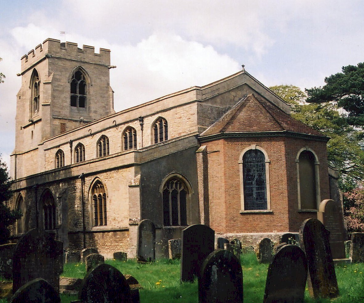
- The Anglican parish church is dedicated to Saint Leodegar (sometimes given as "Leger") and sits, naturally enough, on Church Lane to the east of the village.
- St. Leodegar Church dates back to late 12th century.
- The original church had a crossing tower which collapsed in 1419.
- The church was rebuilt around 1420.
- The church chancel was rebuilt in 1760.
- The church was restored in 1880-81.
- The church seats 240.
- In 1906, the ecclesiastical boundaries were enlarged to include parts of Brothertoft and Skirbeck. This did not affect the civil boundaries.
- A photograph of the parish church exists at the Wendy PARKINSON English Church Photographs site.
- Richard CROFT has a photograph of St. Leodegar's Church on Geo-graph, taken in February, 2009.
- David HITCHBORNE has a photograph of St. Leodegar's tower on Geo-graph, taken in June, 2004.
- Here is a photo of St. Leodegar's Church, taken by Ron COLE (who retains the copyright):
- The Anglican parish register dates back to 1538. it is reportedly in excellent condition.
- The LFHS has published several indexes for the Holland West Deanery to make your search easier.
- Two Wesleyan chapels graced the parish. One in the Marsh and one at West End. For information and assistance in researching these chapels, see our non-conformist religions page.
- Check our Church Records page for county-wide resources.
- The parish was in the Kirton sub-district of the Boston Registration District.
- Check our Civil Registration page for sources and background on Civil Registration which began in July, 1837.
Wyberton (sometimes "Wiberton") is a village and parish just south of Boston and the The Haven (The Haven is the mouth of the River Witham). The parish covers about 3,885 acres. The parish boundary abuts Skirbeck Quarter of Boston and extends southeast to the North Sea.
The eastern end of the village saw a great deal of building from 1930 through the 1950's. If you are planning a visit:
- Take the A16 south out of Boston. It passes through the eastern edge of Wyberton.
- Check our Touring page for additional resources.
- Ask for a calculation of the distance from Wyberton to another place.
William WEBSTER, a British builder who worked with architects and engineers such as Gilbert SCOTT and Joseph BAZALGETTE and is especially associated with several embankments of the River Thames was born here in May 1819. He moved to London in 1860.
Wyberton is listed in the 1086 Domesday Book with 36 households and a church.
Wyberts Castle is a scheduled medieval moated site located at the south end of Wybert Lane, about 1 mile east of Wyberton village.
J. THOMAS has a photograph of the Pincushion Inn on the London Road on Geo-graph, taken in August, 2013.
In April, 2016, Wyberton's mayor, Richard AUSTIN, helped stage Boston UK’s first road Marathon, similar to the one held in Boston, Massachusetts.
- Tytton Hall, in 1912, was the residence of W. T. HORRY. The manorial rights belonged to the Crown.
- See our Maps page for additional resources.
You can see maps centred on OS grid reference TF316413 (Lat/Lon: 52.952944, -0.042581), Wyberton which are provided by:
- OpenStreetMap
- Google Maps
- StreetMap (Current Ordnance Survey maps)
- Bing (was Multimap)
- Old Maps Online
- National Library of Scotland (Old Ordnance Survey maps)
- Vision of Britain (Click "Historical units & statistics" for administrative areas.)
- English Jurisdictions in 1851 (Unfortunately the LDS have removed the facility to enable us to specify a starting location, you will need to search yourself on their map.)
- Magic (Geographic information) (Click + on map if it doesn't show)
- GeoHack (Links to on-line maps and location specific services.)
- All places within the same township/parish shown on an Openstreetmap map.
- Nearby townships/parishes shown on an Openstreetmap map.
- Nearby places shown on an Openstreetmap map.
- The webpage author could find no history of the airfield here.
- The two small hangars that survive from the airfield have been taken over for industrial use.
For a photograph of the Wyberton War Memorial and the names on the plaque, see the Roll of Honour site.
- This place was an ancient parish in Lincolnshire and became a modern Civil Parish when those were established.
- The parish was in the ancient Kirton Wapentake in the Borough of Boston in the parts of Holland.
- In March, 1887, this parish was reduced in size to enlarge Langriville Civil Parish.
- In April, 1906, this parish was reduced in size to enlarge Brothertoft Civil Parish.
- In April, 1906, this parish was reduced in size to enlarge Copping Syke Civil Parish.
- In April, 1906, this parish was reduced in size to enlarge Skirbeck Civil Parish.
- In April, 1932, this parish was enlarged by 121 acres taken from Fishtoft Civil Parish.
- You can contact the local Parish Council about civic or political issues, but they are NOT staffed to answer family history questions.
- For today's district governance, visit the local Boston Borough Council.
- Bastardy cases would be heard in the Kirton and Skirbeck petty session hearings.
- William FIELD's Charity provided four cottages for the poor, rebuilt in 1871. They were available to widows who received 3s. per week.
- Additional charities provided about £12 each year for the poor.
- As a result of the 1834 Poorlaw Amendment Act, this parish became part of the Boston Poor Law Union.
Year Inhabitants 1801 477 1821 487 1831 530 1841 584 1871 617 1881 646 1891 659 1901 627 1911 653 1921 664 1931 829 1951 1,809
- A Public Elementary School was built in 1862 to hold up to 60 children.
- See our Schools page for more information on researching school records.