
Hide
St James Dukes-place
hide
Hide
hide
Hide
Hide
Hide
"ST. JAMES, Duke's-place, the church of, is situated in that part of Duke's-place called the square, and nearly opposite the great Synagogue of the German Jews. Duke's-place is a district covered with lanes and alleys, on a site of part of the once splendid and wealthy priory of the Holy Trinity, founded in 1108, by Matilda, queen of Henry I. Being the richest in England, it was the first that was seized upon by Henry VIII., in 1531, at the period of the dissolution of the religious houses. . . The inhabitants of Duke's-place, wishing to have a parish church to themselves, within their own precinct, applied to the Archbishop of Canterbury, who procured the King's warrant, and prevailed upon the lord mayor, aldermen and common-council, to build them a church with the materials of the conventual church, which then remained upon the premises. This was accordingly done, and the church was consecrated and dedicated to St. James, in honour of the reigning king, James I., on the 2d of January 1622. Although the parish is in in the ward of Aldgate, it is a precinct within itself, under a minister, two constables, two headboroughs and fifteen jurymen. Duke's-place is now principally inhabited by Jews who settled therein in the time of Oliver Cromwell. The church having escaped the fire in 1666, still retains its original form, but the body was rebuilt in 1727. It ia a perpetual curacy, in the city and archdeaconry of London, and in the patronage of the lord mayor and commonalty of Lcodon, who instituted the preset incumbent, the Rev. Richard Povah, D.C.L., in 1823." [James Elmes. A Topographical Dictionary of London and its Environs (1831) - transcribed by Brian Randell]
Hide
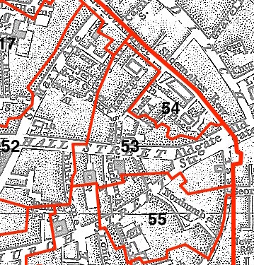
This parish - no. 54 in the above map - is located in Aldgate Ward.
The church was rebuilt post-Wren, demolished 1874.
The parish was later united with St Katherine Cree 1873.
Hide
London Metropolitan Archive holdings for St James Dukes-place.
The Great Synagogue, also known as the Dukes Place Synagogue; historical summary - from the JCR-UK website.
Online Parish Register Images and Indexes for St James Dukes-place parish are provided by, or at various subscription sites via, the LDS FamilySearch wiki.
Phillimore, W. P. W. , Cokayne, George E.(eds.) London parish registers. Marriages at St. James's, Duke's Place, from 1668 to 1837. London: Issued to the subscribers by Phillimore & Co. (1900-1902) 4 vols. [Full text]
Wikipedia page on St James Dukes-place.
- Ask for a calculation of the distance from St James Dukes-place to another place.
Summary history of St James Dukes-place parish, from the Worshipful Company of Parish Clerks.
Public Houses, Inns & Taverns of the parish of St James Dukes-place - provides "information from census records, trade directories, etc."
You can see maps centred on OS grid reference TQ335812 (Lat/Lon: 51.514189, -0.077993), St James Dukes-place which are provided by:
- OpenStreetMap
- Google Maps
- StreetMap (Current Ordnance Survey maps)
- Bing (was Multimap)
- Old Maps Online
- National Library of Scotland (Old Ordnance Survey maps)
- Vision of Britain (Click "Historical units & statistics" for administrative areas.)
- English Jurisdictions in 1851 (Unfortunately the LDS have removed the facility to enable us to specify a starting location, you will need to search yourself on their map.)
- Magic (Geographic information) (Click + on map if it doesn't show)
- GeoHack (Links to on-line maps and location specific services.)
- All places within the same township/parish shown on an Openstreetmap map.
- Nearby townships/parishes shown on an Openstreetmap map.
- Nearby places shown on an Openstreetmap map.
Surnames from the 1881 census in the St James Dukes-place district.
Clerical career summaries for the parish of St James Dukes-place, from the Clergy of the Church of England Database website.
Sources for listings of taxpayer names for St James Dukes-place parish, listed on the LDS FamilySearch wiki.