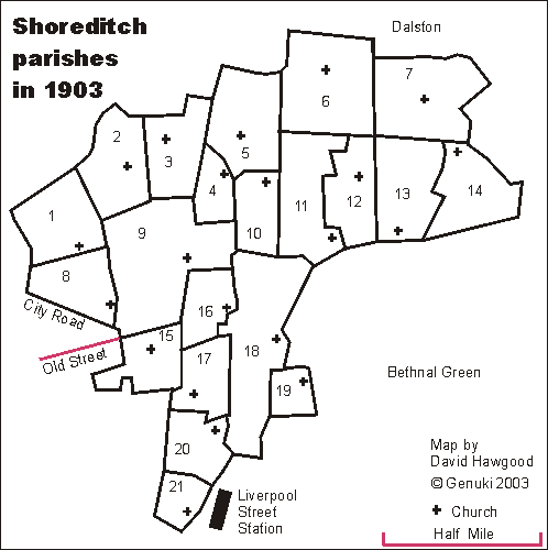
Outline map of parishes of Shoreditch, Middlesex in 1903
Click on a parish name for a fuller description of the parish. Its grid reference and link to a modern street map will be added later. For clearer display or print, see map in pdf format.
|
| - 1 Holy Trinity, Shepherdess Walk, Hoxton
- 2 Christ Church, New North Road, , Hoxton
- 3 St Saviour, Penn Street, Hoxton
- 4 St Anne, Hemsworth Street, Hoxton
- 5 St Andrew, Canal Road, Hoxton
- 6 All Saints, Livermere Road, Haggerston
- 7 St Paul, Broke Road, Haggerston
- 8 St Mary, Britannia Street, Hoxton
- 9 St John the Baptist, New North Road, Hoxton
- 10 St Columba, Kingsland Road, Haggerston
- 11 St Chad, Nichols Square, Haggerston
- 12 St Mary, Brunswick Street, Haggerston
- 13 St Augustine, York Street, Haggerston
- 14 St Stephen, Goldsmith Row, Haggerston
- 15 St Mark, Old Street Road, Shoreditch
- 16 St Peter, Hoxton Square, Hoxton
- 17 St Michael, St Mark Street, Shoreditch
- 18 St Leonard, Shoreditch
- 19 Holy Trinity, Old Nichol Street, Shoreditch
- 20 St James, Curtain Road, Shoreditch
- 21 St Agatha, Finsbury Avenue, E.C.
|
Parish boundaries traced from "A map of the Ecclesiastical Divisions within the County of London, 1903" published by Edward Stanford of London, reprinted as a facsimile by the London Topographical Society. List from that map is of parishes within the rural deanery of Shoreditch in 1903. They are in the Archdeaconry of London, and Diocese of London. We have a list of other deaneries.