
Hide
Kidland
hide
Hide
hide
Hide
Hide
Hide
"KIDLAND LORDSHIP is an extra parochial liberty, situated two miles north by west of Alwinton, the property of Sir Thomas Legard, and comprises an area of 11,825 acres of which the rateable value is £1,742. Population in 1801, 60; in 1811, 54; in 1821, 62; in 1831, 69; in 1841, 63: and in 1851, 61 souls. This is a mountainous district, and the Cheviot breed of sheep are found here in their greatest perfection. The principal mountains in and about this lordship are Cheviot, Cushit, Flint Crag, Hogdon Law, Maiden Cross, Milkhope, Rookland, Shillmoor, &c. The neighbourhood of Kidland Lee, on the west side of the Alwine, is the most fertile part of this district, though the great majority of the hills are covered with rich verdure. Here are the remains of some ancient British entrenchments, and in a romantic glen, near the source of the Alwine, the ruins of Memmerkirk are still visible." [From History, Topography, and Directory of Northumberland, Whellan, 1855].
Hide
- Northumberland County Record Office holds copies of Census Returns 1841 - 1891 and provides a useful User Guide
- The 1851 Census Index (microfiche CN27) published by the https://www.ndfhs.org.uk/ may be of value to researchers interested in this parish.
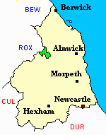
Adjacent Parishes.
- The following parishes are adjacent to Kidland:- Alnham, Alwinton, Kirknewton, Morebattle ROX, Whittingham.
- This area is within Northumberland North Second Registration District.
- Certificates of birth, death and marriage can be ordered from Northumberland County Council.
- The section of The National Gazetteer (1868) relating to this parish - transcribed by Colin Hinson.
- Ask for a calculation of the distance from Kidland to another place.
- The history of Kidland is included in:- Northumberland County History Committee, History of Northumberland, Volume 15. Newcastle, A. Reid, 1940. (Available on fiche from Ancestral Indexes).
You can see maps centred on OS grid reference NT862138 (Lat/Lon: 55.418263, -2.219966), Kidland which are provided by:
- OpenStreetMap
- Google Maps
- StreetMap (Current Ordnance Survey maps)
- Bing (was Multimap)
- Old Maps Online
- National Library of Scotland (Old Ordnance Survey maps)
- Vision of Britain (Click "Historical units & statistics" for administrative areas.)
- English Jurisdictions in 1851 (Unfortunately the LDS have removed the facility to enable us to specify a starting location, you will need to search yourself on their map.)
- Magic (Geographic information) (Click + on map if it doesn't show)
- GeoHack (Links to on-line maps and location specific services.)
- All places within the same township/parish shown on an Openstreetmap map.
- Nearby townships/parishes shown on an Openstreetmap map.
- Nearby places shown on an Openstreetmap map.