
Hide
Briningham
hide
Hide
hide
Hide
hide
Hide
Hide
"BRININGHAM, which gives name to a police division, is 4 miles S.W. by S. of Holt, and has in its parish 243 souls, and 1138 acres of land, mostly in Lord Hastings' manor "on the part of Thornage," (fines arbitrary,) and partly in Lady Suffield's manor of Briningham Chosells. On the north side of the parish is a tower called Belle Vue, belonging to Lord Hastings, and commanding extensive views. The Church (St. Maurice,) is a curacy, valued in 1831 at £62. It is in the patronage and incumbency of the Rev. Shovel Brereton, M.A., who is also impropriator of the tithes, (commuted for £353 per annum,) and has lately erected a handsome parsonage house, on a pleasant eminence, and is also rector of Great Poringland." [William White, History, Gazetteer, and Directory of Norfolk (1845) - Transcription copyright © Pat Newby]
Hide
- The Monumental Inscriptions in the Hundred of Holt (Walter Rye).
- The parishes covered include Briningham.
See Thornage
See also Norfolk Parish Links: Cemeteries
- In 1883 the parish was in the Deanery of Holt, in the archdeaconry of Norwich.
It could have been in a different deanery or archdeaconry both before and after this date. - The parish church is dedicated to St Maurice.
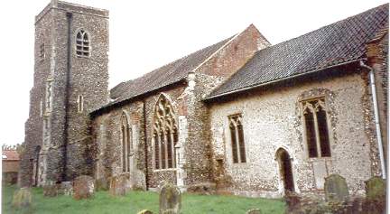
- Church of St Maurice
- Description and pictures.
- Church of St Maurice
- Services, etc.
- Church of St Maurice
- Picture of the church.
- Parish Register Transcripts
- Baptisms 1813-1880
- Archdeacons' Transcripts
- Baptisms 1719-1812, Marriages 1749-1811 and Burials 1720-1812.
[Parish Register Transcription Society, Dart Series, 2000?] - Marriages
- These are not included in Boyd's Marriage Index or Phillimore's Marriage Registers.
See also Norfolk Parish Links: Church Records
For the civil registration of births, marriages and deaths between 1837 and 1930 (and for the censuses from 1851 to 1901), Briningham was in Walsingham Registration District.
- Briningham Post Mill
- Description, history and picture.
- Briningham Belle Vue Smock Mill
- Description, history and pictures.
- Ask for a calculation of the distance from Briningham to another place.
Briningham is in Holt Hundred.
- Parish outline and location.
- See Parish Map for Holt Hundred
- Description of Holt Hundred
- 1845: White's History, Gazetteer, and Directory of Norfolk
- Great Britain. Inclosure Commissioners
- Statement of Claims: Briningham, Stody and Brinton.
Drawn up in pursuance of the Act of Inclosure, 1805.
21 claims for Stody only.
[1806] - Great Britain: Statute
- Briningham, Stody and Brinton Inclosure Act, 1805.
An act for inclosing lands in the parishes of Briningham, Stody, and Brinton in the county of Norfolk.
[An independently printed edition of the act, 1805]
You can see maps centred on OS grid reference TG039342 (Lat/Lon: 52.867057, 1.027648), Briningham which are provided by:
- OpenStreetMap
- Google Maps
- StreetMap (Current Ordnance Survey maps)
- Bing (was Multimap)
- Old Maps Online
- National Library of Scotland (Old Ordnance Survey maps)
- Vision of Britain (Click "Historical units & statistics" for administrative areas.)
- English Jurisdictions in 1851 (Unfortunately the LDS have removed the facility to enable us to specify a starting location, you will need to search yourself on their map.)
- Magic (Geographic information) (Click + on map if it doesn't show)
- GeoHack (Links to on-line maps and location specific services.)
- All places within the same township/parish shown on an Openstreetmap map.
- Nearby townships/parishes shown on an Openstreetmap map.
- Nearby places shown on an Openstreetmap map.
- After 1834 Briningham became part of the Walsingham Union, and the workhouse was at Great Snoring.
These figures are from the population tables which were produced after the 10-yearly national censuses. The "Families" heading includes families and single occupiers.
|
|
There may be more people living in detached parts of the parish (if there were any) and, if so, the number may or may not be included in the figures above. It is quite difficult to be sure from the population tables.
- 1841 Census
- "The decrease of population in Briningham and Bale (or Bathley) is attributed partly to the emigration of a number of persons about four years ago."