
Hide
Salthouse
hide
Hide
hide
Hide
hide
Hide
Hide
"SALTHOUSE, a scattered village, on an acclivity above the salt marshes, half a mile from the beach, and 4 miles N. of Holt, has in its parish 263 souls, and 832 acres of land, . . . The principal landowners are Mrs. Johnson, Wm. Purdy, and Mrs. M.A. Girdlestone. The latter is lady of the manor, and patroness of the Church (St. Nicholas,) which has a lofty tower, and was built by Sir Henry Heydon, in the reign of Henry VII. The living is a discharged rectory, consolidated with Kelling." [William White History, Gazetteer, and Directory of Norfolk (1845) - Transcription copyright © Pat Newby]
Hide
See also Salhouse.
Hide
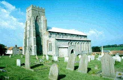
- Salthouse Church and Churchyard
- Inscriptions recorded by Walton N. Dew, as part of "The Monumental Inscriptions in the Hundred of Holt" (Walter Rye). See Thornage for the full list of parishes.
See also Norfolk Parish Links: Cemeteries
See also Norfolk Parish Links: Censuses
- In 1883 the parish was in the Deanery of Holt, in the archdeaconry of Norwich.
- The parish church is dedicated to St Nicholas.
- Church of St Nicholas
- Description, history and pictures.
- Church of St Nicholas
- Description and pictures.
- Church of St Nicholas
- Services, location, etc.
- Church of St Nicholas
- Picture of the church.
- Linnell, Charles Lawrence Scruton
- St Nicholas, Salthouse (with list of rectors).
[North Walsham, 1991] - Linnell, Charles Lawrence Scruton
- Some notes on the ruin in Salthouse churchyard.
[Norwich, Norfolk and Norwich Archaeological Society, in "Norfolk Archaeology", vol.27, 1941]
- Parish Register Transcripts
- Baptisms, Marriages and Burials.
- Marriages
- These are not included in Boyd's Marriage Index or Phillimore's Marriage Registers.
- Friends of Salthouse Church
- The Salthouse buried records, 1538-1713.
The conservation of the buried parish registers.
[Friends of Salthouse Church, CD, 2006] - Churchwardens' Accounts
- 1742-1813
- Churchwardens' Rates
- Principal property occupiers and the amounts paid.
1742, 1762, 1782, and 1782-1784. - Churchwardens' Payments, or Disbursements
- Payments for church repairs, communion bread and wine, etc.
1721-1749, and 1750-1782.
See also Norfolk Parish Links: Church Records
For the civil registration of births, marriages and deaths between 1837 and 1930 (and for the censuses from 1851 to 1901), Salthouse was in Erpingham Registration District.
- Salthouse History
- Description, history, churches, school, memories, maps, family history, pictures, etc.
There is a lot of information here. Several links from this Genuki Norfolk page are direct links into relevant pages on this site. - Salthouse Parish Council
- Councillors, meetings, minutes, etc.
- Salthouse
- Description and pictures.
- Buttercup Joe
- The 1953 floods at Cley, Salthouse and Blakeney.
[Buttercup Publishing, 1992] - Brooks, Peter F.
- Salthouse: Village of character and history.
[ISBN 0946148066, North Walsham, Poppyland Publishing, 1984] - Salthouse Post Mill
- Description and map.
- Salthouse Smock Mill
- Description, history and pictures.
- Salthouse Tower Mill
- Description, history and pictures.
- 1836: White's History, Gazetteer, and Directory of Norfolk
- 1845: White's History, Gazetteer, and Directory of Norfolk
- 1864: White's History, Gazetteer, and Directory of Norfolk
- 1883: White's History, Gazetteer, and Directory of Norfolk
- 1883: Kelly's Directory for Cambridgeshire, Norfolk & Suffolk (this is a link to an archived copy)
See also Norfolk Parish Links: Directories
- Ask for a calculation of the distance from Salthouse to another place.
Salthouse is in Holt hundred.
- Fiddian, Val (editor)
- Salthouse, the story of a Norfolk village.
Based on an unpublished manuscript by Francis Noel Stagg, and updated and continued to 2003.
[ISBN 0954354702, Salthouse History Group, 2003] - Stagg, Francis Noel
- History of the parish of Salthouse in the county of Norfolk.
[Typescript, 1934]
- Parish outline and location.
- See Parish Map for Erpingham Registration District, 1836 (this is a link an archived copy)
and nearby places.
See also Norfolk Parish Links: Maps
You can see maps centred on OS grid reference TG076438 (Lat/Lon: 52.951379, 1.089104), Salthouse which are provided by:
- OpenStreetMap
- Google Maps
- StreetMap (Current Ordnance Survey maps)
- Bing (was Multimap)
- Old Maps Online
- National Library of Scotland (Old Ordnance Survey maps)
- Vision of Britain (Click "Historical units & statistics" for administrative areas.)
- English Jurisdictions in 1851 (Unfortunately the LDS have removed the facility to enable us to specify a starting location, you will need to search yourself on their map.)
- Magic (Geographic information) (Click + on map if it doesn't show)
- GeoHack (Links to on-line maps and location specific services.)
- All places within the same township/parish shown on an Openstreetmap map.
- Nearby townships/parishes shown on an Openstreetmap map.
- Nearby places shown on an Openstreetmap map.
- After 1834 Salthouse became part of the Erpingham Union, and the workhouses were at Gimingham and Sheringham. These were replaced by a new workhouse at West Beckham in 1850.
- Relief of the Salthouse Poor, 1792-1810
- Overseers' Rates
Principal property occupiers and the amounts paid.
1796. - Overseers' Payments, or Disbursements
Payments for outrelief, medical expenses, clothes, etc.
1792-1796, and 1796-1801.
These figures are from the population tables which were produced after the 10-yearly national censuses. The "Families" heading includes families and single occupiers.
|
|
There may be more people living in detached parts of the parish (if there were any) and, if so, the number may or may not be included in the figures above. It is quite difficult to be sure from the population tables.
- 1851 Census
- "About 60 persons dwelling in Salthouse, and about 120 in Cley-next-the-Sea were only temporarily in those Parishes, in consequence of the works of the Salthouse Inclosure and Embankment in progress."
- 1861 Census
- "The decrease of population in the parishes of Weybourne, Salthouse, and Cley-next-the-Sea is attributed to the fact that the return for 1851 included a large number of labourers who were engaged in embanking a tract of marsh land."